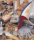
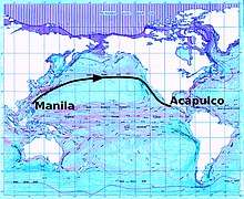
Manila galleon
The Manila Galleons (Spanish: Galeón de Manila; Filipino: Kalakalang Galyon ng Maynila at Acapulco) were Spanish trading ships which for two and a half centuries linked the Philippines with Mexico across the Pacific Ocean, making one or two round-trip voyages per year between the ports of Acapulco and Manila, which were both part of New Spain. The name of the galleon changed to reflect the city that the ship sailed from.[1] The term Manila Galleons is also used to refer to the trade route itself between Acapulco and Manila, which lasted from 1565 to 1815.
Part of a series on the |
|---|
| History of the Philippines |
 |
|
Prehistory (pre–900) Paleolithic age
Events/Artifacts
|
|
Archaic epoch (900–1565) Historically documented city-states/polities
(by geography from North to South)
Legendary
Events/Artifacts
|
|
Colonial period (1565–1946) Spanish era
|
|
Post-colonial period (1946–1986)
|
|
Contemporary history (1986–present)
|
|
By topic
|
| Timeline |
| Archaeology |
|
|
The Manila Galleons were also known in New Spain as "La Nao de la China" (The China Ship) on their return voyage from the Philippines because they carried mostly Chinese goods, shipped from Manila.
The Manila Galleon trade route was inaugurated in 1565 after Augustinian friar and navigator Andrés de Urdaneta discovered the tornaviaje or return route from the Philippines to Mexico. The first successful round trips were made by Urdaneta and by Alonso de Arellano that year. The route lasted until 1815 when the Mexican War of Independence broke out. The Manila galleons sailed the Pacific for 250 years, bringing to the Americas cargoes of luxury goods such as spices and porcelain, in exchange for silver. The route also created a cultural exchange that shaped the identities and culture of the countries involved.
In 2015, the Philippines and Mexico began preparations for the nomination of the Manila-Acapulco Galleon Trade Route in the UNESCO World Heritage List, with backing from Spain. Spain has also suggested the tri-national nomination of the Archives on the Manila-Acapulco Galleons in the UNESCO Memory of the World Register.
Discovery of the route
In 1521, a Spanish expedition led by Ferdinand Magellan sailed west across the Pacific using the westward trade winds. The expedition discovered the Mariana Islands and the Philippines and claimed them for Spain. Although Magellan died there, one of his ships, the Victoria, made it back to Spain by continuing westward.
In order to settle and trade with these islands from the Americas, an eastward maritime return path was necessary. The first ship to try this a few years later failed. In 1529, Álvaro de Saavedra Cerón also tried sailing east from the Philippines, but could not find the eastward winds across the Pacific. In 1543, Bernardo de la Torre also failed. In 1542, however, Juan Rodríguez Cabrillo helped pave the way by sailing north from Mexico to explore the Pacific coast, reaching as far north as the Russian River, just north of the 38th parallel.
The Manila-Acapulco galleon trade finally began when Spanish navigators Alonso de Arellano and Andrés de Urdaneta discovered the eastward return route in 1565. Sailing as part of the expedition commanded by Miguel López de Legazpi to conquer the Philippines in 1565, Arellano and Urdaneta were given the task of finding a return route. Reasoning that the trade winds of the Pacific might move in a gyre as the Atlantic winds did, they had to sail north to the 38th parallel north, off the east coast of Japan, before catching the eastward-blowing winds ("westerlies") that would take them back across the Pacific.
Reaching the west coast of North America, Urdaneta's ship the San Pedro hit the coast near Cape Mendocino, California, then followed the coast south to San Blas and later to Acapulco, arriving on October 8, 1565.[2] Most of his crew died on the long initial voyage, for which they had not sufficiently provisioned. Arellano, who had taken a more southerly route, had already arrived.
The English privateer Francis Drake also reached the California coast, in 1579. After capturing a Spanish ship heading for Manila, Drake turned north, hoping to meet another Spanish treasure ship coming south on its return from Manila to Acapulco. He failed in that regard, but staked an English claim somewhere on the northern California coast. Although the ship's log and other records were lost, the officially accepted location is now called Drakes Bay, on Point Reyes south of Cape Mendocino.[lower-alpha 1][11]
By the 18th century, it was understood that a less northerly track was sufficient when nearing the North American coast, and galleon navigators steered well clear of the rocky and often fogbound northern and central California coast. According to historian William Lytle Schurz, "They generally made their landfall well down the coast, somewhere between Point Conception and Cape San Lucas ... After all, these were preeminently merchant ships, and the business of exploration lay outside their field, though chance discoveries were welcomed".[12]
The first motivation for land exploration of present-day California was to scout out possible way-stations for the seaworn Manila galleons on the last leg of their journey. Early proposals came to little, but in 1769, the Portola expedition established ports at San Diego and Monterey (which became the administrative center of Alta California), providing safe harbors for returning Manila galleons.
In Manila, the safety of ocean crossings was commended to the virgin Nuestra Señora de la Soledad de Porta Vaga in masses held by the Archbishop of Manila. If the expedition was successful the voyagers would go to the La Ermita (church) to pay homage, and offer gold and other precious gems or jewelries from Hispanic countries, to the image of the virgin. So it came to be that the Virgin was named the "Queen of the Galleons".
The Manila Galleon and California
Monterey, California was about two months and three weeks out from Manila in the 18th century, and the galleon tended to stop there 40 days before arriving in Manila. Galleons stopped in Monterey prior to California's settlement by the Spanish in 1769, however visits become regular between 1777 and 1794 because the Crown ordered the galleon to stop in Monterey.
Spice trade
Trade with Ming China via Manila served a major source of revenue for the Spanish Empire and as a fundamental source of income for Spanish colonists in the Philippine Islands. Until 1593, two or more ships would set sail annually from each port.[13] The Manila trade became so lucrative that Seville merchants petitioned king Philip II of Spain to protect the monopoly of the Casa de Contratación based in Seville. This led to the passing of a decree in 1593 that set a limit of two ships sailing each year from either port, with one kept in reserve in Acapulco and one in Manila. An "armada" or armed escort of galleons, was also approved. Due to official attempts at controlling the galleon trade, contraband and understating of ships' cargo became widespread.[14]
Between 1609 and 1616, 9 galleons and 6 galleys were constructed in Philippine shipyards. The average cost was 78,000 pesos per galleon and at least 2,000 trees. The galleons constructed included the San Juan Bautista, San Marcos, Nuestra Senora de Guadalupe, Angel de la Guardia, San Felipe, Santiago, Salbador, Espiritu Santo, and San Miguel. "From 1729 to 1739, the main purpose of the Cavite shipyard was the construction and outfitting of the galleons for the Manila to Acapulco trade run."[15]
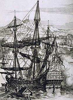
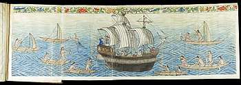
Due to the route's high profitability but long voyage time, it was essential to build the largest possible galleons, which were the largest class of European ships known to have been built until then.[16] In the 16th century, they averaged from 1,700 to 2,000 tons, were built of Philippine hardwoods and could carry 300 - 500 passengers. The Concepción, wrecked in 1638, was 43 to 49 m (141 to 161 ft) long and displacing some 2,000 tons. The Santísima Trinidad was 51.5 m long. Most of the ships were built in the Philippines and only eight in Mexico. The Manila-Acapulco galleon trade ended in 1815, a few years before Mexico gained independence from Spain in 1821. After this, the Spanish Crown took direct control of the Philippines, and governed directly from Madrid. Sea transport became easier in the mid-19th century upon the invention of steam power ships and the opening of the Suez Canal, which reduced the travel time from Spain to the Philippines to 40 days.
The galleon trade was supplied by merchants largely from port areas of Fujian who traveled to Manila to sell the Spaniards spices, porcelain, ivory, lacquerware, processed silk cloth and other valuable commodities. Cargoes varied from one voyage to another but often included goods from all over Asia - jade, wax, gunpowder and silk from China; amber, cotton and rugs from India; spices from Indonesia and Malaysia; and a variety of goods from Japan, including fans, chests, screens and porcelain.[17]
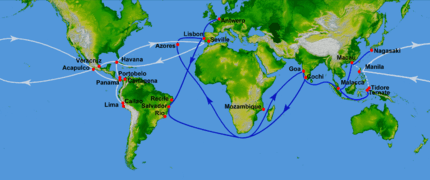
Galleons transported the goods to be sold in the Americas, namely in New Spain and Peru as well as in European markets. East Asia trading primarily functioned on a silver standard due to Ming China's use of silver ingots as a medium of exchange. As such, goods were mostly bought by silver mined from Mexico and Potosí.[14] In addition, slaves from various origins were transported from Manila.[18] The cargoes arrived in Acapulco and were transported by land across Mexico to the port of Veracruz on the Gulf of Mexico, where they were loaded onto the Spanish treasure fleet bound for Spain.
Around 80% of the goods shipped back from Acapulco to Manila were from the Americas - silver, cochineal, seeds, sweet potato, tobacco, chickpea, chocolate and cocoa, watermelon, vine and fig trees. The remaining 20% were goods transhipped from Europe and North Africa such as wine and olive oil, and metal goods such as weapons, knobs and spurs.[17]
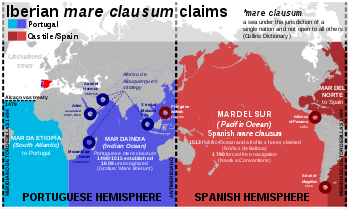
This Pacific route was the alternative to the trip west across the Indian Ocean, and around the Cape of Good Hope, which was reserved to Portugal according to the Treaty of Tordesillas. It also avoided stopping over at ports controlled by competing powers, such as Portugal and the Netherlands. From the early days of exploration, the Spanish knew that the American continent was much narrower across the Panamanian isthmus than across Mexico. They tried to establish a regular land crossing there, but the thick jungle and malaria made it impractical.
It took at least four months to sail across the Pacific Ocean from Manila to Acapulco, and the galleons were the main link between the Philippines and the viceregal capital at Mexico City and thence to Spain itself. Many of the so-called "Kastilas" or Spaniards in the Philippines were actually of Mexican descent, and the Hispanic culture of the Philippines is somewhat close to Mexican culture.[19] Soldiers and settlers recruited from Mexico and Peru were also gathered in Acapulco before they were sent to settle at the Presidios of the Philippines.[20] Even after the galleon era, and at the time when Mexico finally gained its independence, the two nations still continued to trade, except for a brief lull during the Spanish–American War.
The wrecks of the Manila galleons are legends second only to the wrecks of treasure ships in the Caribbean. In 1568, Miguel López de Legazpi's own ship, the San Pablo (300 tons), was the first Manila galleon to be wrecked en route to Mexico. Between the years 1576 when the Espiritu Santo was lost and 1798 when the San Cristobal (2) was lost there were twenty Manila galleons[21] wrecked within the Philippine archipelago.
At least one galleon, probably the Santo Cristo de Burgos, is believed to have wrecked on the coast of Oregon in 1693. Known as the Beeswax wreck, the event is described in the oral histories of the Tillamook and Clatsop, which suggest that some of the crew survived.[22][23][24]
Between 1565 and 1815 Spain owned 108 galleons, of which 26 were lost at sea for various reasons. Significant galleon captures by the British occurred in 1587 when the Santa Anna was captured by Thomas Cavendish, in 1709 with the Encarnacion, in 1743 when the Nuestra Senora de la Covadonga was taken by George Anson on his voyage around the world, and in 1762 with the Nuestra Senora de la Santisima Trinidad. Until 1593, four galleons travelled at the same time, later only two.[15]:492
Crews
Sailors averaged age 28 or 29 while the oldest were between 40 and 50. Ships pages were children who entered service mostly at age 8, many orphans or poor taken from the streets of Seville, Mexico and Manila. Apprentices were older than the pages and if successful would be certified a sailor at age 20. Because mortality rates were high with ships arriving in Manila with a majority of their crew often dead from starvation, disease and scurvy, especially in the early years, Spanish officials in Manila found it difficult to find men to crew their ships to return to Acapulco. Many indios of Filipino and Southeast Asian origin made up the majority of the crew. Other crew were made up of deportees and criminals from Spain and the colonies. Many criminals were sentenced to serve as crew on royal ships. Less than a third of the crew was Spanish and they usually held key positions onboard the galleon. [25]
Possible discovery of Hawaii
For 250 years, hundreds of Manila galleons traveled from present-day Mexico to the Philippines, with their route taking them south of the Hawaiian Islands. And yet, no historical records of any contact between the two cultures exist. British historian Henry Kamen maintains that the Spanish did not have the ability to properly explore the Pacific Ocean, and were not capable of finding the islands which lay at a latitude 20° north of the westbound galleon route and its currents.[26] However, Spanish activity in the Pacific was paramount until the late 18th century. Spanish expeditions discovered Guam, the Marianas, the Carolines and the Philippines in the North Pacific, as well as Tuvalu, the Marquesas, the Solomon Islands and New Guinea in the South Pacific. Spanish navigators also discovered the Pitcairn and Vanuatu archipelagos during their search for Terra Australis in the 17th century.
This navigational activity poses questions as to whether Spanish explorers did arrive in the Hawaiian Islands two centuries before Captain James Cook's first visit in 1778. Ruy López de Villalobos commanded a fleet of six ships that left Acapulco in 1542 with a Spanish sailor named Ivan Gaetan or Juan Gaetano aboard as pilot. Depending on the interpretation, Gaetano's reports seem to describe either the discovery of Hawaii or the Marshall Islands in 1555.[27] If it was Hawaii, Gaetano would have been one of the first Europeans to find the islands.
The westward route from Mexico passed south of Hawaii, making a short stopover in Guam before heading for Manila. The exact route was kept secret to protect the Spanish trade monopoly against competing powers, and to avoid Dutch and English pirates. Due to this policy of discretion, if the Spanish did find Hawaii during their voyages, they would not have published their findings and the discovery would have remained unknown. From Gaetano's account, the Hawaiian islands were not known to have any valuable resources, so the Spanish would not have made an effort to settle them.[27] This happened in the case of the Marianas and the Carolines, which were not effectively settled until the second half of the 17th century. Spanish archives contain a chart that depicts islands in the latitude of Hawaii but with the longitude ten degrees east of the Islands (reliable methods of determining longitude were not developed until the mid-eighteenth century). In this manuscript, the Island of Maui is named "La Desgraciada" (the unhappy, or unfortunate), and what appears to be the Island of Hawaii is named "La Mesa" (the table). Islands resembling Kahoolawe, Lanai, and Molokai are named "Los Monjes" (the monks).[28]
The theory that the first European visitors to Hawaii were Spanish is reinforced by the findings of William Ellis, a writer and missionary who lived in early 19th century Hawaii, and recorded several folk stories about foreigners who had visited Hawaii prior to first contact with Cook. According to Hawaiian writer Herb Kawainui Kane, one of these stories:
concerned seven foreigners who landed eight generations earlier at Kealakekua Bay in a painted boat with an awning or canopy over the stern. They were dressed in clothing of white and yellow, and one wore a sword at his side and a feather in his hat. On landing, they kneeled down in prayer. The Hawaiians, most helpful to those who were most helpless, received them kindly. The strangers ultimately married into the families of chiefs, but their names could not be included in genealogies".[27]
Some scholars, particularly American, have dismissed these claims as lacking credibility.[29][30] Debate continues as to whether the Hawaiian Islands were actually visited by the Spanish in the 16th century[31] with researchers like Richard W. Rogers looking for evidence of Spanish shipwrecks.[32][33]
Pending UNESCO nominations
In 2014, the idea to nominate the Manila-Acapulco Galleon Trade Route as a World Heritage Site was initiated by the Mexican and Filipino ambassadors to UNESCO. Spain has also backed the nomination and suggested that the archives related to the route under the possession of the Philippines, Mexico, and Spain be nominated as part of another UNESCO list, the Memory of the World Register.[34]
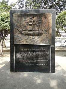
In 2017, the Philippines established the Manila-Acapulco Galleon Museum in Metro Manila, one of the necessary steps in nominating the trade route to UNESCO.[35]
See also
| Wikimedia Commons has media related to Manila galleon. |
- Asian Mexicans
- Battles of La Naval de Manila
- Bernardo de la Torre
- Chamorro people
- Filipino immigration to Mexico
- History of the Philippines (1521–1898)
- History of the west coast of North America
- María de Lajara
- Mexican settlement in the Philippines
- Pedro Cubero
- Pedro de Unamuno
- Spanish East Indies
- Spanish Main
- Spanish treasure fleet
Notes
- The Drakes Cove site began its review by the National Park Service (NPS) in 1994,[3] thus starting an 18-year study of the suggested Drake sites. The first formal Nomination to mark the Nova Albion site at Drake's Cove as a National Historic Landmark was provided to NPS on January 1, 1996. As part of its review, NPS obtained independent, confidential comments from professional historians. The NPS staff concluded that the Drake's Cove site is the "most probable"[3] and "most likely"[4][5][6][7] Drake landing site. The National Park System Advisory Board Landmarks Committee sought public comments on the Port of Nova Albion Historic and Archaeological District Nomination [8] and received more than two dozen letters of support and none in opposition. At the Committee's meeting of November 9, 2011 in Washington, DC, representatives of the government of Spain, the National Oceanic and Atmospheric Administration and Congresswoman Lynn Wolsey all spoke in favor of the nomination: there was no opposition. Staff and the Drake Navigators Guild’s president, Edward Von der Porten, gave the presentation. The Nomination was strongly endorsed by Committee Member Dr. James M. Allan, Archaeologist, and the Committee as a whole which approved the nomination unanimously. The National Park System Advisory Board sought further public comments on the Nomination,[9] but no additional comments were received. At the Board's meeting on December 1, 2011 in Florida, the Nomination was further reviewed: the Board approved the nomination unanimously. On October 16, 2012 Secretary of the Interior Ken Salazar signed the nomination and on October 17, 2012, The Drakes Bay Historic and Archaeological District was formally announced as a new National Historic Landmark.[10]
References
- Williams, Glyn (1999). The Prize of All the Oceans. New York: Viking. p. 4. ISBN 0-670-89197-5.
- Derek Hayes (2001). Historical atlas of the North Pacific Ocean: maps of discovery and scientific exploration, 1500–2000. Douglas & McIntyre. p. 18. ISBN 9781550548655.
- "Archived copy" (PDF). Archived from the original (PDF) on 2014-02-22. Retrieved 2015-09-28.CS1 maint: archived copy as title (link)
- "Archived copy" (PDF). Archived from the original (PDF) on 2014-02-22. Retrieved 2015-09-28.CS1 maint: archived copy as title (link)
- "University of California Archaeological Site Survey Record, Mrn-230". Winepi.com. Archived from the original (DOC) on 25 May 2017. Retrieved 23 February 2019.
- "A Brief History of Scholarship Relating to Drake's Port of Nova Albion". Winepi.com. Archived from the original (DOC) on 25 May 2017. Retrieved 24 February 2019.
- "National Historic Landmarks Property Name: Drakes Bay Historic and Archeological District". Winepi.com. Archived from the original (DOC) on 25 May 2017. Retrieved 24 February 2019.
- "Landmarks Committee of the National Park System Advisory Board Meeting". Federal Register. 8 September 2011. Retrieved 23 February 2019.
- "Federal Register, Volume 76 Issue 189 (Thursday, September 29, 2011)". Govinfo.gov. Retrieved 23 February 2019.
- "Interior Designates 27 New National Landmarks". Doi.gov. 17 October 2012. Retrieved 23 February 2019.
- "The Drake Navigators Guild Press Release". Winepi.com. Archived from the original on October 17, 2016. Retrieved February 21, 2013.
- Schurz 1917, p.107-108
- Schurz, William Lytle. The Manila Galleon, 1939. P 193.
- Charles C. Mann (2011), 1493: Uncovering the New World Columbus Created, Random House Digital, pp. 123–163, ISBN 9780307596727
- Fish, Shirley (2011). The Manila-Acapulco Galleons: The Treasure Ships of the Pacific. AuthorHouse. pp. 128–130. ISBN 9781456775421.
- See Chinese treasure ship for Chinese vessels that might have been larger.
- Mejia, Javier. "The Economics of the Manila Galleon" (PDF). New York University, Abu Dhabi. Retrieved 3 February 2019. Cite journal requires
|journal=(help) - Tatiana Seijas (23 June 2014). Asian Slaves in Colonial Mexico: From Chinos to Indians. Cambridge University Press. ISBN 978-1-139-95285-9.
Rose, Christopher (13 January 2016). "Episode 76: The Trans-Pacific Slave Trade". 15 Minute History. University of Texas at Austin. Retrieved 13 January 2016. - Guevarra, Rudy P. (2007). Mexipino: A History of Multiethnic Identity and the Formation of the Mexican and Filipino Communities of San Diego, 1900–1965. University of California, Santa Barbara. ISBN 0549122869
- "Forced Migration in the Spanish Pacific World" By Eva Maria Mehl, page 235.
- "Archived copy". Archived from the original on 2016-01-10. Retrieved 2020-03-24.CS1 maint: archived copy as title (link)
- Williams, Scott S. (2016). "Chapter 8: The Beeswax Wreck, A Manila Galleon in Oregon, USA". In Wu, Chunming (ed.). Early Navigation in the Asia-Pacific Region: A Maritime Archaeological Perspective. Springer. pp. 146–168. ISBN 978-981-10-0904-4. Retrieved 23 October 2019.
- La Follette, Cameron; Deur, Douglas (July 2018). "Views Across the Pacific: The Galleon Trade and Its Traces in Oregon". Oregon Historical Quarterly. Oregon Historical Society. 119 (2): 160–191. doi:10.5403/oregonhistq.119.2.0160. Retrieved 23 October 2019.
- La Follette, Cameron; Deur, Douglas; Griffin, Dennis; Williams, Scott S. (July 2018). "Oregon's Manila Galleon". Oregon Historical Quarterly. Oregon Historical Society. 119 (2): 150–159. doi:10.5403/oregonhistq.119.2.0150.
- Leon-Guerrero, Jillette. "Manila Galleon Crew Members". Guampedia. Retrieved 18 October 2019.
- Kamen, Henry (2004). Empire: How Spain Became a World Power, 1492–1763. HarperCollins. ISBN 0060932643.
- Kane, Herb Kawainui (1996). "The Manila Galleons". In Bob Dye (ed.). Hawaiʻ Chronicles: Island History from the Pages of Honolulu Magazine. I. Honolulu: University of Hawaii Press. pp. 25–32. ISBN 0-8248-1829-6.
- Hawaii National Park. (June 1959). "Hawaii Nature Notes". The Publication of the Naturalist Division, Hawaii National Park, and the Hawaii Natural History Association.
- By Oliver, Douglas L. (1989). The Pacific Islands. University of Hawaii Press. p. 45. ISBN 0824812336
- Coulter, John Wesley. (Jun, 1964) "Great Britain in Hawaii: The Captain Cook Monument". The Geographical Journal, Vol. 130, No. 2. doi:10.2307/1794586
- Horwitz, Tony. (2003). Blue Latitudes: Boldly Going Where Captain Cook Has Gone Before. p.452. ISBN 0-312-42260-1
- Rogers, Richard W. (1999). Shipwrecks of Hawaii: A Maritime History of the Big Island. Pilialoha Press
- "Perhaps the leading authority on Hawaiian shipwrecks today", writes Peter von Buol, referring to Richard W. Rogers in the Fall 2006, Vol. 38, No. 3 issue of Prologue, published by the NARA.
- "Archived copy". Archived from the original on 2017-12-14. Retrieved 2017-12-14.CS1 maint: archived copy as title (link)
- "Manila-Acapulco Galleon Museum rises in SM MOA". Bbusinessmirror.com.ph.
Further reading
- Bjork, Katharine. "The Link that Kept the Philippines Spanish: Mexican Merchant Interests and the Manila Trade, 1571–1815." Journal of World History vol. 9, no. 1, (1998) 25-50.
- Carrera Stampa, Manuel. "La Nao de la China." Historia Mexicana 9 no. 33 (1959) 97-118.
- Fish, Shirley. The Manila-Acapulco Galleons: The Treasure Ships of the Pacific, with an Annotated List of the Transpacific Galleons 1565–1815. Central Milton Keynes, England: Authorhouse 2011.
- Luengo, Josemaria Salutan. A History of the Manila-Acapulco Slave Trade, 1565–1815. Tubigon, Bohol: Mater Dei Publications 1996.
- McCarthy, William J. "Between Policy and Prerogative: Malfeasance in the Inspection of the Manila Galleons at Acapulco, 1637." Colonial Latin American Historical Review 2, no. 2 (1993) 163-83.
- Oropeza Keresey, Deborah. "Los 'indios chinos' en la Nueva España: la inmigración de la Nao de China, 1565–1700." PhD dissertation, El Colegio de México, Centro de Estudios Históricos, 2007.
- Rogers, R. (1999). Shipwreck of Hawai'i: a maritime history of the Big Island. Haasdasdleiwa, Hawfasfasfaii: Piliagagasgaloha Pub. ISBN 0967346703
- Schurz, William Lytle. (1917) "The Manila Galleon and California", Southwestern Historical Quarterly, Vol. 21, No. 2, pp. 107–126
- Schurz, William Lytle. The Manila Galleon. New York: E. P. Dutton & Co., Inc., 1939.
External links
- Findings from the wreck of Nuestra Senora de la Concepcion in the Marianas, 1638
- Metropolitan Museum: Manila Galleon
- Manila Galleons along the Californian coasts
- Asociación Cultural Galeón de Manila, Spanish-Philippine research group based in Madrid (in Spanish)