Fiordland
Fiordland is a geographic region of New Zealand in the south-western corner of the South Island, comprising the western-most third of Southland. Most of Fiordland is dominated by the steep sides of the snow-capped Southern Alps, deep lakes, and its steep, glacier-carved and now ocean-flooded western valleys. The name "Fiordland" comes from a variant spelling of the Scandinavian word for this type of steep valley, "fjord". The area of Fiordland is dominated by, and very roughly coterminous with, Fiordland National Park, New Zealand's largest National Park.

Due to the often steep terrain and high amount of rainfall supporting dense vegetation, the interior of the Fiordland region is largely inaccessible. As a result, Fiordland was never subjected to notable logging operations, and even attempts at whaling, seal hunting, and mining were on a small scale and shortlived, partly also because of the challenging weather.[1] Today, Fiordland contains by far the greatest extent of unmodified vegetation in New Zealand and significant populations of endemic plants and threatened animals, in some cases the only remaining wild populations.
Fiordland features a number of fiords, which in this area are typically named sounds even though geologically they are not. Of the twelve major fiords on Fiordland's west coast, Milford Sound is the most famous and the only one accessible by road. Doubtful Sound, which is much larger, is also a tourist destination, but is less accessible as it requires a boat trip over Lake Manapouri and bus transfer over Wilmot Pass.
Also situated within Fiordland are Browne Falls and Sutherland Falls, which rank among the tallest waterfalls in the world, and New Zealand's three deepest lakes, Lake Hauroko, Lake Manapouri, and Lake Te Anau. Several other large lakes lie nearby, and Fiordland and the surrounding parts of Southland and Otago Regions are often referred to as the Southern Lakes. Only a handful of Fiordland's lakes are accessible by road - Lake Poteriteri is the largest lake in New Zealand with no road access. Many of the region's lakes are not even accessible via tramping tracks.
This part of New Zealand, especially to the west of the mountain divide of the Southern Alps, has a very wet climate with annual average of 200 rainy days and annual rainfall varying from 1,200 millimetres (47 in) in Te Anau to 8,000 millimetres (310 in) in Milford Sound.[2][3] The prevailing westerly winds blow moist air from the Tasman Sea onto the mountains, resulting in high amounts of precipitation as the air rises and cools down.
History
Fiordland has never had any significant permanent population. The Maori people knew the area well but only visited seasonally, for hunting, fishing and to collect the precious stone pounamu (New Zealand jade) from Anita Bay and the mouth of Milford Sound.[4]
In Maori legend, demi-god Tu-te-raki-whanoa carved the fiords from rock using his adze, perfecting his technique as he progressed from south to north, with the last fiord, Piopiotahi (Milford Sound) being his greatest achievement.
In 1773, Captain James Cook and his crew were the first Europeans to visit Fiordland, anchored in Dusky Sound for five weeks. The expedition's maps and descriptions of the area attracted whalers and seal hunters, but it was not until the mid-19th century that surveyors and prospectors began exploring Fiordland's interior.[5]
Between 1897 and 1908, two attempts at establishing a mining operation in the remote area of Preservation Island failed, and by 1914, the isolated small settlement of Cromartie had been abandoned.[1] The area was administered as Fiord County from 1876 until it was absorbed into neighbouring Wallace County in 1981. Since 1989 it has been part of Southland District, and the wider Southland Region.
Boundary

There are currently varying definitions for the boundary of the Fiordland region. The eastern boundary of Fiordland according to Statistics New Zealand stretches from Sand Hill Point on the western end of Te Waewae Bay more or less straight north, cutting through Lake Hauroko, Lake Monowai, Lake Manapouri, Lake Te Anau's South Fiord, before veering northwest and ending with the southern side of George Sound.[6] By that definition, the Fiordland region is almost entirely within the Fiordland National Park, except for small pockets near the two southernmost lakes, but the area does not include the three northernmost fiords Milford Sound, Southerland Sound, and Bligh Sound.
The much more widespread definition of "Fiordland" has an eastern boundary that roughly follows that of the Fiordland National Park for all but the northernmost end. This area contains all fiords as well as the Hollyford Valley and also includes the area around Big Bay, which lies to the north outside of the Fiordland National Park, but still belongs to the Southland Region. This definition of the Fiordland region is used by tourism organisations[7] and the Department of Conservation.[8][9] The towns of Te Anau and Manapouri are generally also referred to as being within the Fiordland region, even though they are outside of the boundary of the national park.[10][5]
Geography

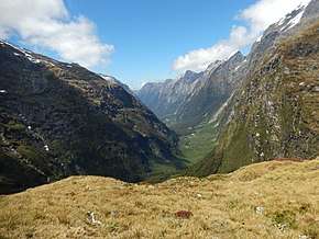
In geographical terms, the Fiordland region contains the huge mountainous regions west of the line from Te Waewae Bay to Monowai to Te Anau, and includes the valleys of the Eglinton River and Hollyford River. The area is almost identical to that of the Fiordland National Park, and is marked by U-shaped valleys and fiords along the coast and steep mountains with foundations of hard rocks like gneiss, schist, granite and diorite, with the softer rock having been carved out by multiple glaciations. Fiordland contains New Zealand's oldest known plutonic (igneous) rocks[11] and is dominated by the southernmost extent of the Southern Alps as the peaks reduce in height from north to south.
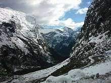
The tallest mountain in the Fiordland region is Mount Tutoko at 2,723 metres (8,934 ft),[12] one of several peaks over 2,000 meters in the Darren Mountains. Southeast of this area, there are only a handful of peaks reaching 2,000 meters, however due to the rainy weather with cold winters and lack of hot summer temperatures, even these mountains contain glaciers and peaks with permanent snow cover. The southernmost glacier is situated on Caroline Peak[13], which only reaches 1,704 metres (5,591 ft),[14] and in the southwest of Fiordland the altitude for permanent snowfields lowers to under 1,500 metres (4,900 ft).[15]
The past glaciation's deep carving out of the landscape has also resulted in fiord-like arms in Lake Manapouri and Lake Te Anau, and on the coast managed to cause several large chunks of the mainland becoming cut off. The largest of these uninhabited offshore islands are Resolution Island and Secretary Island, and are important conservation sites, particularly as sanctuaries for endangered native birds.
Constituent fiords
.jpg)
Twelve fiords, some stretching up to 40 kilometres (25 mi) inland, and two inlets leading to three more fiords, extend along the coast from Milford Sound in the north to Preservation Inlet in the south. In general, the fiords become wider from north to south as the height of the mountains decreases. The outlets of the southernmost fiords have a character more akin to inlets, with only the inner arms such as Long Sound resembling fiords.
- Milford Sound - the only fiord in the area with road access
- Sutherland Sound
- Bligh Sound
- George Sound - accessible via tramping track
- Caswell Sound
- Charles Sound
- Nancy Sound
- Thompson Sound
- Doubtful Sound - accessible via tours and tramping track
- Dagg Sound
- Breaksea Sound
- Dusky Sound - accessible via tramping track
- Chalky Inlet - leads into Edwardson Sound and Cunaris Sound
- Preservation Inlet - leads into Long Sound
A further sound, Bradshaw Sound, is basically an extension of Thompson and Doubtful Sounds after their junction at the eastern end of Secretary Island.
Ecology
The area has been categorised as the Fiordland temperate forests ecoregion, having a variety of habitats and due to its isolation a high number of endemic plants. Much of Fiordland is heavily forested except for locations where surface rock exposures are extensive. The natural habitats are almost completely unspoilt. Nothofagus beech trees are dominant in many locations, silver beech (Nothofagus menziesii) in the fiords and red beech (Nothofagus fusca) in the inland valleys. In the understory there are a wide variety of shrubs and ferns, including crown fern (Blechnum discolor), areas of scrubby herbs above the treeline, patches of bog next to mountain streams and finally an area of rimu (Dacrydium cupressinum)-dominated sandunes in the Waitutu area on the south coast.[17] Despite a latitude in the mid 40s, the treeline is generally below 1,000 metres (3,300 ft) because of the cool summers and the influence of the southern ocean on the climate.[18]
The area is home to threatened native bird species such as the flightless takahe and kiwi, blue duck (whio), and yellowhead (mohua). The takahe was presumed to have been extinct for 50 years before a small remaining population was discovered in Fiordland's Murchison Mountains in 1948. Since then, that area has been managed by the Department of Conservation, trapping stoats and controlling deer, helping takahe numbers in the area to increase to over 200 and remain at that level.[19]
There are also a great number of insects and one indigenous reptile, the Fiordland skink (Oligosoma acrinasum).[20] There are around 300 insect species endemic to the Fiordland region, many of them sizeable, such as weta, large caddis, and giant weevils, and some of them unusual, such as egg-laying worms, alpine cicadas, and brightly coloured alpine moths.[21] There are six species of native sandflies (blackfly, Simuliidae) with one endemic to Fiordland.[22]
Most of the area falls under the protection of the Fiordland National Park, part of the Te Wahipounamu World Heritage Site. Fiordland National Park has an area of 12,600 square kilometres[23], making it the largest national park in New Zealand and one of the larger parks in the world, containing many tourist attractions, such as Milford Sound, Doubtful Sound and the Milford Track. The main threat to natural habitats is from introduced species, especially red deer, but these are now being hunted out of the area, and furthermore the park includes a number of small offshore islands which are free from introduced species and are designated Specially Protected Areas.
Several offshore areas of Fiordland are protected as part of Fiordland's marine reserves.
Demographics and economy

Apart from the areas around the townships of Te Anau and Manapouri, at the edge of Fiordland, the Fiordland region has never had more than a few human inhabitants and is the least-populated area of the South Island (12 residents in 2013, virtually uninhabited),[24][25] with no villages or towns, and many areas almost inaccessible except by boat or air. The only settlements close by / in Fiordland (depending on definition) are Manapouri and Te Anau townships, which together have around 2,100 permanent inhabitants[26][27] and over 4,000 tourist beds.[28] The Fiordland region receives 1.2 million visitors per year, staying for a combined 1 million visitor nights.[29] The nearest city is Invercargill, about 80 kilometres (50 mi) east of southern end of Fiordland. The only major road in Fiordland is State Highway 94, also referred to as Milford Road, connecting Te Anau with Milford Sound.
Blanket Bay Hotel, not an actual hotel, may be the westernmost inhabited locality of New Zealand. The fishermen's refuelling and supply depot with a small jetty and helipad is located on a small island at the head of Doubtful Sound.[30][31]
Except for electricity generation (at the Manapouri Power Station and a smaller hydro-electric power station at Lake Monowai) and some agriculture, tourism is the only other major economic factor of the region. Visitor spending was NZ$92 million in 2003, and 1,017 people were employed full-time in the tourism industry, with an additional 1,900 people considered to be employed in tourism industry support services.[32] Most tourists visit Milford Sound, though walking in the more accessible eastern parts of the alps is a popular activity. Nonetheless, the remoteness of the region limits even tourism, and after short visits to the major sites, most tourists return to other areas, such as Queenstown or Invercargill.
See also
References
- "Historic Tarawera Silver Mine and Smelter: Historic sites in Fiordland National Park". Department of Conservation. Retrieved 30 September 2017.
- "Fiordland a World Heritage area". Deep Cove Charters.
- "Fiordland & Stewart Island/Rakiura" (PDF). Lonely Planet.
- "Fiordland's History - Destination Fiordland". Destination Fiordland. Retrieved 27 September 2017.
- "Fiordland: An introduction - Tourism New Zealand Media". Tourism New Zealand. Retrieved 27 September 2017.
- "Boundary Map of Fiordland". Statistics New Zealand. Retrieved 27 September 2017.
- "RTONZ - Regional Tourism Organisations New Zealand - RTO Location Map". Regional Tourism Organisations New Zealand. Retrieved 27 September 2017.
- "Fiordland: Places to go". Department of Conservation. Retrieved 27 September 2017.
- "Big Bay Hut: Fiordland Region". Department of Conservation. Retrieved 27 September 2017.
- "Fiordland - Destination Fiordland". Destination Fiordland. Retrieved 27 September 2017.
- "Geological Map of Fiordland". GNS Science. Retrieved 27 September 2017.
- "Mount Tutoko, Southland – NZ Topo Map". NZ Topo Map. Land Information New Zealand. Retrieved 27 September 2017.
- "Glaciers and glaciation". Te Ara: The Encyclopedia of New Zealand. Retrieved 27 September 2017.
- "Caroline Peak, Southland – NZ Topo Map". NZ Topo Map. Land Information New Zealand. Retrieved 27 September 2017.
- "Geological Factors in Fiordland Ecology" (PDF). N.Z. Geological Survey, Dunedin. Retrieved 27 September 2017.
- "Milford Sound - Destination Fiordland". Destination Fiordland. Retrieved 29 July 2017.
- C. Michael Hogan. 2009. Crown Fern: Blechnum discolor, Globaltwitcher.com, ed. N. Stromberg Archived February 13, 2012, at the Wayback Machine
- "Fiordland National Park Management Plan" (PDF). Department of Conservation. June 2007. p. 18. Retrieved 27 September 2017.
- "Murchison Mountains: Where takahe live". Department of Conservation. Retrieved 2 January 2017.
- "Fiordland temperate forests". Terrestrial Ecoregions. World Wildlife Fund.
- "3. Southland Region - Te Ara Encyclopedia of New Zealand". Te Ara: The Encyclopedia of New Zealand. Retrieved 29 September 2017.
- Taylor-Smith, Briar; Morgan-Richards, Mary; Trewick, Steven A. (2019). "Patterns of regional endemism among New Zealand invertebrates". New Zealand Journal of Zoology. 0: 1–19. doi:10.1080/03014223.2019.1681479. ISSN 0301-4223.
- "Fiordland National Park Management Plan" (PDF). Department of Conservation. June 2007. p. 15. Retrieved 27 September 2017.
- "2013 Census QuickStats about a place: Fiordland". Statistics New Zealand. Retrieved 27 September 2017.
- Note that the census area cited here is the area defined as "Fiordland" by Statistics New Zealand.
- "2013 Census QuickStats about a place: Te Anau". Statistics New Zealand. Retrieved 27 September 2017.
- "2013 Census QuickStats about a place: Manapouri". Statistics New Zealand. Retrieved 27 September 2017.
- "Review of the Tourism Aspects of the Fiordland Link Experience Project Application" (PDF). Department of Conservation. February 2014. p. 7. Retrieved 27 September 2017.
- "Southland Visitor Profile December 2013" (PDF). Venture Southland. December 2013. p. 19, 20. Retrieved 27 September 2017.
- Blanket Bay Hotel on satellite photo (from Wikimapia website. Accessed 2017-09-14.)
- Harpham, Perce (2012). Some Voyages Around New Zealand and Elsewhere. p. 57. ISBN 978-0-473-23832-2.
- Milford Sound Transport - Issues and Options (GHD Ltd for Venture Southland, 2005)
External links
| Wikivoyage has a travel guide for Fiordland National Park. |
| Wikimedia Commons has media related to Fiordland National Park. |
- Destination Fiordland – tourism organisation