Wajir County
Wajir County is a county in the former North Eastern Province of Kenya. Its capital and largest town is Wajir. The county has a population of 1201,007 and an area of 55,840.6 km². The county is bordered to the north by Ethiopia, to the northeast by Mandera County, to the east by Somalia, to the south by Garissa County, to the west by Isiolo County and to the northwest by Marsabit County. The county has six constituencies: Eldas,elnur , Tarbaj, Wajir North, Wajir West, Wajir East, and Wajir South.
Wajir County | |
|---|---|
 Flag  Coat of arms | |
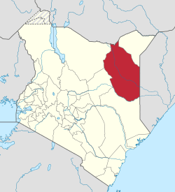 Location of Wajir County in Kenya | |
| Coordinates: 1.74722°N 40.0689°E | |
| Country | |
| Formed | March 4, 2013 |
| Capital and largest town | Wajir |
| Other towns | |
| Government | |
| • Governor | H.E. Mohamed Abdi Mohamud
|
| Area | |
| • Total | 55,840.6 km2 (21,560.2 sq mi) |
| • Land | Other towns km2 (Formatting error: invalid input when rounding sq mi) |
| Population (2019)[2] | |
| • Total | 781,263 |
| • Density | 14/km2 (36/sq mi) |
| Time zone | UTC+3 (EAT) |
| Website | www |

Geography and Climate
The county consists of a featureless plain that rises from around 150m above sea level in the south and east up to 400m in the north. The area is prone to seasonal flooding as well as seasonal swamps. Wajir county has a semi-arid climate with annual rainfall of around 240mm.[3]
Population
| Historical population | ||
|---|---|---|
| Year | Pop. | ±% |
| 1979 | 139,319 | — |
| 1989 | 122,769 | −11.9% |
| 1999 | 319,261 | +160.1% |
| 2009 | 661,941 | +107.3% |
| 2019 | 781,263 | +18.0% |
| source:[4] | ||
| Urban Centre | 2009 Population[5] |
|---|---|
| Wajir | 82,800 |
| Habaswein | 21,890 |
| Bute | 19,723 |
| Tarbaj | 16,043 |
| Eldas | 15,243 |
| Griftu | 9,550 |
County subdivisions
Sub-counties
As of 2019, Wajir County is divided into 7 sub-counties:[2]
| Sub-county | Population | Land area (Sq. km) | Pop. density |
|---|---|---|---|
| Buna | 49,886 | 3,892.8 | 13 |
| Eldas | 88,509 | 4,444.0 | 20 |
| Habaswein | 174,134 | 10,912.5 | 16 |
| Tarbaj | 57,232 | 9,650.9 | 6 |
| Wajir East | 110,654 | 4,055.1 | 27 |
| Wajir North | 62,206 | 4,042.9 | 15 |
| Wajir South | 116,814 | 10,732.6 | 11 |
| Wajir West | 121,828 | 9,042.3 | 13 |
Divisions
Wajir County is divided into fourteen administrative divisions:
| Division | Population* | Pop. density* | Area (km²) | Headquarters |
|---|---|---|---|---|
| Buna | 29,160 | 5 | x | Buna |
| Bute | 14,684 | 20 | x | Bute |
| Central | 51,006 | 22 | x | Wajir |
| Diff | 19,052 | 3 | x | |
| Eldas | 9,166 | 4 | x | Eldas |
| Sarman | 29,166 | 4 | x | Sarman |
| Griftu | 42,333 | 6 | x | Griftu |
| Gurar | 18,087 | 7 | x | Gurar |
| Habaswein | 27,467 | 6 | x | Habaswein |
| Hadado | 19,787 | 5 | x | Hadado |
| Kotulo | 23,016 | 9 | x | Kotulo |
| Lafaley | 5,883 | 12 | x | |
| Lagboqol | 25,699 | 3 | x | Lagboqol |
| Tarbaj | 62,758 | 4 | x | Tarbaj |
| Wajir-Bor | 17,046 | 4 | x | |
| Total | 366,847 | 4 | x | |
| * 1999 census[6] | ||||
Villages and settlements
- El Ben
- Bute Helu
- Giriftu
- Khorof Harar
- Adadijole
- Sarman
- Diif
- Buna
- Eldas
- Hadaado
References
- https://www.wajir.go.ke/
- "2019 Kenya Population and Housing Census Volume I: Population by County and Sub-County". Kenya National Bureau of Statistics. Retrieved 6 November 2019.
- "Wajir County Integrated Development Plan (CIDP 2018-2022)". Maarifa. Retrieved 3 December 2019.
- Kenya: Administrative Division population statistics
- "CIDP Marsabit 2018-2022". Maarifa Centre. Retrieved 11 November 2019.
- "Status of Coverage of Communications Services" (PDF). www.cck.go.ke. Archived from the original (PDF) on 30 May 2009. Retrieved 17 July 2017.