Baringo County
Baringo County is one of the 47 Counties of Kenya. It is located in the former Rift Valley Province. Its headquarters and largest town is Kabarnet. The county is home to Lake Baringo.
Baringo County | |
|---|---|
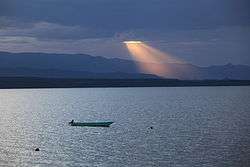 Sunset over Lake Baringo, Baringo County, Kenya | |
 Flag  Coat of arms | |
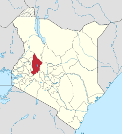 Location in Kenya | |
| Country | |
| Formed | 4 March 2013 |
| Capital | Kabarnet |
| Government | |
| • Governor | Stanley Kiptis |
| Area | |
| • Total | 11,075.3 km2 (4,276.2 sq mi) |
| Population (2019 census) | |
| • Total | 666,763 |
| • Density | 60/km2 (160/sq mi) |
| Time zone | UTC+3 (EAT) |
| Website | baringo.go.ke |
Geographical location
Baringo bounded by Turkana County and West Pokot County to the North, Samburu County and Laikipia County to the East, Nakuru County and Kericho County to the South, Uasin Gishu County to the South West and Elgeyo Marakwet County to the West. It covers an area of 8,655 sq km. Baringo County lies between Latitudes 00 degrees 13" South and 1 degree 40" north and Longitudes 35 degrees 36" and 36" degrees 30" East.[1]
Administrative and Political Units
Baringo has five administartive sub-counties
- Baringo Central
- East Pokot
- Koibatek
- Marigat
- Mogotio
- Tiaty East
Administrative and Electoral Units in Baringo County
Baring county has a total of thirty electoral wards and one hundred and sixteen electoral wards.[2] The electoral wards is run by an elected member of county assemby where-areas location is led by Chief appointed.
| Sub-County | Area KM sq | Electoral Wards | Locations |
| Baringo South | 1,678 | 4 | 17 |
| Mogotio | 1,315 | 3 | 24 |
| Eldama Ravine | 1,003 | 6 | 16 |
| Baringo Central | 800 | 5 | 21 |
| Baringo North | 1,704 | 5 | 14 |
| Tiaty | 4,517 | 7 | 24 |
| Total | 11,015 | 30 | 116 |
Demographics
The county has a population of 666,763 (2019 census) and an area of 10,976.4 km2 (4,238.0 sq mi).[6]
| Historical population | ||
|---|---|---|
| Year | Pop. | ±% |
| 1979 | 203,792 | — |
| 1989 | 347,990 | +70.8% |
| 1999 | 403,141 | +15.8% |
| 2009 | 555,561 | +37.8% |
| 2019 | 666,763 | +20.0% |
| source:[7] | ||
Distribution of Population by Sex and Sub-County
| Subcountty | Male | Female | Intersex | Total | |
|---|---|---|---|---|---|
| 1 | Baringo Central | 48,120 | 48,829 | 2 | 96,951 |
| 2 | Baringo North | 52,369 | 52,500 | 2 | 104,871 |
| 3 | East Pokot | 40,462 | 39,459 | 2 | 79,923 |
| 4 | Koibatek | 65,295 | 64,238 | 2 | 129,535 |
| 5 | Marigat | 45,706 | 45,246 | 3 | 90,955 |
| 6 | Mogotio | 47,014 | 45,088 | 2 | 91,104 |
| 7 | Tiaty East | 38,356 | 35,068 | - | 91,104 |
| TOTAL | 336,322 | 330,428 | 13 | 666,673 |
Religion and ethnicities
The county is occupied by the Tugen, lembus, Pokot and Njemps. A sizeable population of Nubians is found in Eldama-Ravine. Christianity is the most practiced religion in the county. Baringo county has many tribes including Tugens, Njemps, Pokots, Turkanas, Kikuyus, Numbians and Kisiis. Traditionally, Baringo people believed in a god Asis, who is represented by the sun; however, currently, most individuals in the county believe in Christianity.[10] The well-known Christian denominations within Baringo County include the Anglican Church of Kenya (ACK), African Inland Church (AIC), and Roman Catholic.[11]
County government
The County Governor is Stanley Kiptis and is deputized by Jacob Kurui Chepkwony. The Senator is Gideon Moi while the County Women is Gladwell Tungo. The County Executive Committee consists of the following:
| CEC Member | Docket |
|---|---|
| Mrs. Scola Jepkesei Kimeliy | Industrialization, Commerce Tourism and Enterprise Development |
| Mrs. Lilian Sadalla | Land, Housing and Urban Planning |
| Mr. Edwin Riamangura | Youth, Gender, Labour and Social Services |
| Mr. Job Kibei Tomno | Water and Irrigation |
| Ms. Caroline Lentupuru | Environment and Natural Resources |
| Mr. Philemon Rono | Transport and Infrastructure |
| Mrs. Emily Kibet | Education |
| Mr. Lukah Rotich | Agriculture, Livestock and Fisheries |
Economics
The economy of the county is mainly agro-based. The main food crops grown are maize, pigeon peas, beans, Irish potatoes, sweet potatoes, sorghum, cassava and finger millet while the cash crops are coffee, cotton, macadamia and pyrethrum.[12] Livestock products include honey, beef, mutton as well as hides and skins. However, little value addition is done to these products.
Urbanization
Major urban centres in the county are Kabarnet, Eldama Ravine, Marigat, Mogotio, Kabartonjo and Chemolingot.
Tourism and Wildlife
Major attractions include:[13]
- Lake Bogoria and Kapedo Hotsprings
- Lake Bogoria Game Reserve is home to rare kudus, antelopes, zebras, leopards, cheetahs, hyenas, mongoose, monkeys, baboons and jackals. At the shores of Lake Bogoria are more than two millions lesser flamingoes and 350 bird species total.
- Lake Baringo
- Lake Baringo Snake Park has many snake species such as the black mamba, puff adder, boomslang and spitting cobra, monitor lizards, crocodiles and tortoises.
- Kabarnet National Museum and Kipsaraman Community Museum
- Ruko Conservancy
Major tourist hotels in the county are:
- Lake Bogoria Hotel and Spa Resort
- Kabarnet Hotel, Kabarnet
- Sinkoro Hotel Ltd, Kabarnet
- Soi Safari Lodge
- Sportsline Hotel, Kabarnet
- Taidy’s Restaurant, Eldama Ravine
- Kibelion Hotel, Emining
Education
Kabarnet town hosts a number of university campuses including those of Mount Kenya University, Egerton University, and Kisii University.
Secondary schools include Kabarnet High School, Baringo High School, Kapropita High School, and Kituro High School, Tabagon Girls, Pemwai Girls, Tenges Boys among others
There are six hundred and eighty seven primary schools, out of this 601 are public and 86 are private schools.[2] In Secondary school category they are a total of one hundred and fifty nine (159) schools; one hundred and forty seven being public secondary schools and twelve being private public secondary schools.[14]
Health
Kabarnet County Referral Hospital is the largest and best public hospital in the county. There are a total of 172 health facilities; seven level four, 25 level three and 140 level 2 centres.[15]
Transport and infrastructure
The county headquarters is linked to Nakuru and Eldoret by class C roads which fall under the Kenya National Highways Authority (KENHA).
In January 2016, Fly-SAX began twice-weekly flights between Lake Baringo Airport and Nairobi–Wilson, becoming the first airline to serve the airport.[16][2]
There are 339km bitumen, 2141 murram and 995km earth roads in the county.[17][18] As at 2014 a total of 9 postal offices were spread across the county with letter boxes of 2950 installed, 2510 rented and 440 vacant.[19]
Constituencies
The county has six constituencies: Baringo Central, Baringo South, Baringo North, Eldama Ravine, Mogotio, and Tiaty.
Villages and settlements
{{columns-list|colwidth=10em|
- Bartabwa
- Bartolimo
- Barwesa
- Cheberen
- Chemogoch
- Chemoigut
- Chemosusu
- Chepkesin
- Emening
- Kabimoi
- Kabluk
- Kamar
- Kamarabuyon
- Kampi Ya Samaki
- Kapchepkor
- Kapkalelwa
- Kapkiam
- Kapluk
- Kaption
- Kapturwo
- Kasisit
- Kimnai
- Kimngorom
- Kimose
- Kinyach
- Kipcherere
- Kiptagich
- Kolloa
- Langarwa
- Logumukum
- Loiminange
- Lorwok
- Maji Moto
- Mugurin
- Mukutan
- Noiwe
- Nosuguro
- Nyalilpuch
- Sibillo
- Sorok
- tenges
- cheplambus
- kisonei
- eitui
References
- "Baringo County Government - Home". www.baringo.go.ke. Retrieved 28 May 2020.
- Kenya National Bureau of Statistics (2015). County Statistical Abstract Baringo County. Kenya National Bureau of Statistics.
- "Publications". Kenya National Bureau of Statistics. Retrieved 25 May 2020.
- "Baringo County Government - Who We Are". www.baringo.go.ke. Retrieved 25 May 2020.
- interior_admin. "Home". interior.go.ke. Retrieved 25 May 2020.
- Kenya National Bureau of Statistics (2019). 2019 Kenya Population and Housing Census. Kenya National Bureau of Statistics.
- Kenya: Administrative Division population statistics
- Munene, Evans (4 November 2019). "2019 Kenya Population and Housing Census Results". Kenya National Bureau of Statistics. Retrieved 25 May 2020.
- "Publications". Kenya National Bureau of Statistics. Retrieved 25 May 2020.
- "About Baringo County in Kenya". www.kenya-information-guide.com. Retrieved 7 December 2019.
- "About Baringo County in Kenya". www.kenya-information-guide.com. Retrieved 7 December 2019.
- "Agriculture, Livestock and Fisheries". www.baringo.go.ke. Archived from the original on 3 February 2014. Retrieved 2014-02-07.
- "Industrialization, Commerce, Tourism & Enterprise Development". www.baringo.go.ke. Archived from the original on 3 February 2014. Retrieved 2014-02-07.
- "Home". www.education.go.ke. Retrieved 25 May 2020.
- "Baringo County Government - Health Services". baringo.go.ke. Retrieved 25 May 2020.
- "Fly SAX starts flights to Lake Baringo". African Aerospace. 14 December 2015. Retrieved 5 February 2016.
- "Home". www.kerra.go.ke. Retrieved 25 May 2020.
- "Baringo Region". www.kerra.go.ke. Retrieved 25 May 2020.
- "Postal Corporation of Kenya". www.posta.co.ke. Retrieved 25 May 2020.
External links
- https://web.archive.org/web/20181126221543/https://www.findingkenya.com/baringo-county
- https://web.archive.org/web/20130511020558/https://opendata.go.ke/facet/counties/Baringo
- https://web.archive.org/web/20140322145500/http://baringo-county.kbo.co.ke/
- http://www.aridland.go.ke/districts.asp?DistrictID=8%5B%5D
- http://www.reliefweb.int/rw/RWB.NSF/db900SID/VBOL-6TNC5G?OpenDocument
- Map of the District
- Baringo County
- 32 Best Places to See in Baringo County - Finding Kenya Travel Directory