Marsabit
Marsabit is a town in the northern Marsabit County in Kenya. It is situated in the former Eastern Province and is almost surrounded by the Marsabit National Park and Marsabit National Reserve. The town is located 170 km east of the center of the East African Rift, at 37°58' E, 2°19' N (37.97°E, 2.32 N) at an elevation of between 1300 and 1400 metres.[1] It serves as the capital of Marsabit County, and lies southeast of the Chalbi Desert in a forested area known for its volcanoes and crater lakes and others.
Marsabit | |
|---|---|
Town | |
 The Marsabit-Moyale road. | |
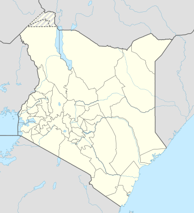 Marsabit Location in Kenya. | |
| Coordinates: 2°20′00″N 37°59′00″E | |
| Country | |
| County | Marsabit County |
| Elevation | 1,350 m (4,430 ft) |
| Time zone | UTC+3 (EAT) |
Overview
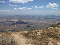
The town of Marsabit is an outpost of urban civilization in the vast desert of northern Kenya. The town is situated on an isolated extinct volcano, Mount Marsabit, which rises almost a kilometer above the desert. The hills here are heavily forested, in contrast to the desert beyond, with their own "insular" eco-system. The town currently has a population of about 5,000.
The town is mainly inhabited by the Cushitic-speaking Borana Oromo people. There are also very few Nilotic Turkana and Bantu Ameru residents. Additionally, there are also few non-Cushitic-speaking traders.
Marsabit has an airstrip and a mountain peak (Mount Marsabit), with "singing" wells just outside the town. Elephants can also often be seen in the local wildlife refuge that surrounds the town, occasionally breaking down fences and causing damage to local farmers' crop beds.
The name is possibly from the Amharic word 'Marsa bet' (Meaning Marsa's home/house) and is believed to have been named after a farmer named 'Marsa' (ethnically Burji) who was brought to Marsabit from Mega (in Ethiopia) by the Consul to assist in consolidation of farming and permanent settlement on the slopes of Mount Marsabit.
Culture and religion

Besides the aforementioned ethnic groups, there are other people from other parts of Kenya who are there working mostly for the government and business. Muslims, Christians and adherents of traditional religions all inhabit the town.
Marsabit is the announced location for a conference between Borana and Gabra elders scheduled for 2–6 June 2009. Discussions to resolve existing conflicts between the two groups have been underway for several years now, and agreements are expected to be sealed at the event at this conference in the presence of traditional leaders.[2]
Transport
.jpg)
Marsabit is approximately 550 kilometers or 7 - 8 Hour drive from Nairobi via the towns of Isiolo and Archers Post. Reaching the town was previously a challenge as you had to either hang on top of the trucks or hike lifts in government vehicles. Currently, there are multiple bus services which ply the Isiolo-Marsabit route on a daily basis. It leaves Isiolo for Marsabit at 8pm, arriving between 3 and 5am and leaves Marsabit at 8am arriving in Isiolo between 3 and 7pm. In addition to this, there are other buses which ply the Nairobi-Moyale route, through Marsabit.
The road has been recently paved and connects all the way to the Kenya-Ethiopia Border at Moyale. It is approximately 277 kilometers from Isiolo and takes between 3 and 4 hours.
There are two airstrips servicing charter aircraft, one close to town, about 10 minutes' drive towards Moyale (Marsabit Airstrip), and the second about 30 minutes away towards Chalbi (Segel Airstrip). The Mission Aviation Fellowship (MAF) flight is the only regular flight to Marsabit on Tuesdays and Fridays.
Economy

Marsabit town is a trading and commercial centre, with three petrol stations, three commercial banks, post office, shops, restaurants, lodges and even a dry cleaner. The town facilitates the supply and movement of goods and services between Moyale (goods from Ethiopia) and Isiolo (goods from Nairobi). Agriculture also plays a role, as many grow millet and maize to be consumed locally and nomadic people supply beef by selling their cows.
Lake Paradise (which attracts game animals such as elephants and buffalo), and Bongole Crater located in the heart of the forest are both local attractions for tourists. The town and surrounding area are of rich cultural interest to anthropologists and other researchers.
Solar eclipse of November 3, 2013
Marsabit was listed as one of the locations that would experience a total solar eclipse on November 3, 2013. The total solar eclipse would have lasted a maximum of 1 minute and 39 seconds. About 1,000 tourists flocked to Sibiloi national park to get a glimpse of the rare occurrence.[3]
Climate
Marsabit has an altitude-influenced dry-summer tropical savanna climate (Köppen climate classification: As).
| Climate data for Marsabit | |||||||||||||
|---|---|---|---|---|---|---|---|---|---|---|---|---|---|
| Month | Jan | Feb | Mar | Apr | May | Jun | Jul | Aug | Sep | Oct | Nov | Dec | Year |
| Average high °C (°F) | 25.0 (77.0) |
25.7 (78.3) |
25.7 (78.3) |
24.9 (76.8) |
24.8 (76.6) |
24.4 (75.9) |
23.8 (74.8) |
24.1 (75.4) |
25.1 (77.2) |
25.2 (77.4) |
23.8 (74.8) |
24.2 (75.6) |
24.7 (76.5) |
| Average low °C (°F) | 15.7 (60.3) |
15.9 (60.6) |
16.2 (61.2) |
16.7 (62.1) |
16.1 (61.0) |
14.6 (58.3) |
13.8 (56.8) |
13.5 (56.3) |
14.0 (57.2) |
15.4 (59.7) |
16.0 (60.8) |
15.9 (60.6) |
15.3 (59.5) |
| Average precipitation mm (inches) | 92 (3.6) |
60 (2.4) |
91 (3.6) |
149 (5.9) |
54 (2.1) |
14 (0.6) |
17 (0.7) |
8 (0.3) |
9 (0.4) |
62 (2.4) |
91 (3.6) |
46 (1.8) |
693 (27.3) |
| Average precipitation days | 6 | 3 | 7 | 9 | 5 | 4 | 3 | 4 | 2 | 6 | 9 | 6 | 64 |
| Source: World Meteorological Organization[4] | |||||||||||||
Notes
- https://www.mountain-forecast.com/peaks/Marsabit/forecasts/1707
- "Borana and Gabra peace meeting in Dukana" Archived 2009-03-30 at the Wayback Machine, Pastoralists Communication Initiative website (accessed 5 May 2009)
- Chao, Sandra (November 1, 2013). "Numbers rise as tourists flock Marsabit for eclipse Sunday". Daily Nation. Retrieved 3 November 2013.
- "World Weather Information Service – Marsabit". World Meteorological Organization. Retrieved 31 August 2016.