Kiambu County
Kiambu County is a county in the former Central Province of Kenya. Its capital is Kiambu and its largest town is Thika.[3] Kiambu County borders Nairobi and Kajiado Counties to the South, Machakos to the East, Murang‘a to the North and North East, Nyandarua to the North West, and Nakuru to the West and has a population of 2,417,735.[4][5]
Kiambu County | |
|---|---|
 The fourteen Falls | |
 Flag | |
 Location in Kenya | |
| Coordinates: 1°10′S 36°50′E | |
| Sovereign state | |
| Region | Central Province |
| Established | 4 March 2013 (by 2010 Constitution of Kenya) |
| Preceded by | Central Province |
| Capital | Kiambu Town |
| Seat of Government | Thika Town |
| Wards | 60[1] |
| Government | |
| • Governor | Dr. James Nyoro |
| • Judiciary | 12 |
| Area | |
| • Total | 2,449.2 km2 (945.6 sq mi) |
| Population (2019 census) | |
| • Total | 2,417,735 |
| • Density | 990/km2 (2,600/sq mi) |
| Time zone | UTC+3 (East Africa Time) |
| Senator | Kimani Wamatangi |
| Woman Member of National Assembly | Gathoni wa Muchomba |
| County Assembly | County Assembly of Kiambu |
| Speaker | Stephen Ndichu[2] |
| Website | www |
The county is 40% rural and 60% urban owing to Nairobi's consistent growth Northwards. Kikuyu are the dominant tribe in the county.
In 2007, Kiambu District was subdivided in two: Kiambu East and Kiambu West. Kiambu West district took Limuru, Lari and Kikuyu divisions,[6] with Limuru as its district capital.
Climatic Conditions
The county has an average rainfall of 1,200 mm. and mean temperature of 26 °C with temperatures as low in upper highlands areas of Limuru. The long rains starts in mid March to May and cold runs between July and August.[7]
Demographics
There is a total population of 2,417,735 of which 1,187,146 are males, 1,230,454 females and 135 intersex persons. There are 796,241 household with an average household size of 3.0 persons per household and a population density 952 people per square kilometre.
| Sub-County | Male | Female | Intersex | Total |
|---|---|---|---|---|
| Gatundu North | 54,189 | 55,678 | 3 | 109,870 |
| Gatundu South | 60,384 | 61,714 | 5 | 122,103 |
| Githunguri | 82,037 | 83,187 | 8 | 165,232 |
| Juja | 148,446 | 152,480 | 22 | 300,948 |
| Kabete | 97,794 | 101,845 | 14 | 199,653 |
| Kiambaa | 115,690 | 120,695 | 15 | 236,400 |
| Kiambu | 69,661 | 76,225 | 17 | 145,903 |
| Kikuyu | 90,919 | 96,198 | 5 | 187,122 |
| Lari | 67,061 | 68,238 | 4 | 135,303 |
| Limuru | 79,632 | 79,682 | 159,314 | |
| Ruiru. | 180,947 | 190,144 | 20 | 371,111 |
| Thika East | 19,688 | 19,264 | 4 | 38,956 |
| Thika West | . ...1 2 0 , 6 9 8 | 125,104 | 18 | 245,820 |
| Total | 1,187,146 | 1,230,454 | 135 | 2,417,735 |
Source [9]
Administrative and political units
Administrative Units
Administratively the county is divided into twelve sub counties, sixty county assembly wards, ninety seven locations and two hundred and fifty seven sub-locations. MOI
Electoral Constituncies
- Gatundu North Constituency
- Gatundu South Constituency
- Githunguri Constituency
- Juja Constituency
- Kabete Constituency
- Kiambaa Constituency
- Kiambu Constituency
- Kikuyu Constituency
- Lari Constituency
- Limuru Constituency
- Ruiru Constituency
- Thika East Constituency
- Thika West Constituency
Political leadership
Dr James Nyoro is the governor of kiambu county following impeachment of Ferdinand Waititu (elected for a five-year term during 2017 general election) over misuse of public office and corruption on 19 December 2019.[10][11][12] Paul Kimani Njoroge Wamatangi has been senator since 2013 and he was rel-elected in 2017 general elections.[13][14]Gathoni Wamuchomba is the second Women representative after and came into office in 2017 after defeating the Annah Gatheca the first Women representative.[15]
Although the capital is Kiambu town, the executive conducts business from Thika town.
County Executive Committee comprises of:-
| Number | |
|---|---|
| The Governor | 1 |
| The Deputy Governor | 1 |
| The County Secretary | 1 |
| The CEC Members | 10 |
| Total | 13 |
Source [16]
Legislature
The legislature of Kiambu County is a unicameral County Assembly. It is composed of 60 elected Members of County Assembly (MCA) from the sixty wards of the county and 27 nominated members.[1] The members hold office for a five-year term each, renewable during the general election. The speaker and deputy speaker of the assembly are elected by the MCAs. The county Assembly is located at Kiambu town.
Judiciary
Kiambu High Court was established on 20 June 2016.[17] As of 2017, it consists of a one-judge bench. It is temporarily located at Thika waiting for a permanent building to be constructed at Kiambu, the capital.
County Administration
The county has a county administrator who is appointed by the President of Kenya. He is not part of the county government but is a representative of the President to assist with matters of administration in the county with regards to the national government.[18]
Education
The are 1515 ECD centres 948 primary schools and 365 secondary schools. The county also has 33 Youth Polytechnics, 1 technical training institutions, technical institute of technology, 1 University.[19]
| Category | Public | Private | Total | Enrolment |
|---|---|---|---|---|
| ECD Centres | 552 | 963 | 1515 | 99,061 |
| Primary schools | 476 | 472 | 948 | 326,770 |
| Secondary schools | 271 | 94 | 365 | 116,366 |
| Youth Polytechnics | 33 | 0 | 33 | |
| Technical Training Institutes | 1 | 0 | 1 | |
| Adult Education Centres | 165 | 0 | 165 | 6128 |
| Institutes of Technology | 1 | 0 | 1 | |
| University | 1 | 0 | 1 |
Health
The are a total of 505 health facilities, of this 108 are public, 64 are faith based and 333 are private health facilities. County has 2652 health personnel of different cadre with a doctor/population ratio of 1:6667, while the nurse population ratio is at 1;1110. The immunisation coverage is at 89% almost same with the national target of 90%.[21]
HIV prevalence is at 5.6% below the national 5.9% (HIV estimates released in 2016 ) and the county is ranked 6th in terms of HIV burden.[22]
| Government | *FBO | Private | TOTAL | |
|---|---|---|---|---|
| Hospitals | 14 | 11 | 26 | 51 |
| Health centres | 33 | 8 | 0 | 41 |
| Dispensaries | 72 | 21 | 0 | 93 |
| Clinics | 0 | 0 | 147 | 147 |
| Total | 119 | 40 | 173 | 332 |
Source Ministry of Health, County Government of Kiambu[23][24]
Transport and Communication
The county is covered by 2,049.8Km of road network. of this 459 km is covered by earth surface, 1,075.8 km is murram surface and 515 km is covered by bitumen.[25]
There are 19 Post Offices.[24]
Trade and Commerce
There are 302 trading centres, 118 markets, 364 retail supermarkets, 5,813 registered businesses, 5807 licensed retail traders and 5,740 licensed wholesale traders.[24][26]
Tatu city a special economic zone is an industrial park that is located in Ruiru sub-county. The county has quite a number of major industries such as gro processing industries are spread across the county and includes Farmers Choice Ltd, 25 Kenchic Co. Ltd, Brookside Dairies, Githunguri Dairies, Ndumberi Dairies, Limuru Milk and Palmside Dairies. Thika sub-county has 58 industries including Bidco Oil Industries, Devki Steel Mills, Broadway Bakeries and Kenblest Industry among others.[27]
Constituencies/Sub Counties
The county has twelve constituencies/Sub-counties:
- 1. Githunguri
- Githunguri Ward
- Githiga Ward
- Ikinu Ward
- Ngewa Ward
- Komothai 3 Ward
- 2. Kiambaa
- Cianda Ward
- Karuri Ward
- Ndenderu Ward
- Muchatha Ward
- Kihara Ward
- 3. Kabete
- Gitaru Ward
- Muguga Ward
- Nyathuna Ward
- Kabete Ward
- Uthiru Ward
- 4. Limuru
- Bibirioni Ward
- Limuru Central Ward
- Ndeiya Ward
- Limuru East Ward
- Ngecha Tigoni Ward
- 5. Lari
- Kinale Ward
- Kijabe Ward
- Nyanduma Ward
- Kamburu Ward
- Lari/Kirenga Ward
- 6. Gatundu North
- Gituamba Ward
- Githobokoni Ward
- Chania Ward
- Mang’u Ward
- 7. Gatundu South
- Kiamwangi Ward
- Kiganjo Ward
- Ndarugo Ward
- Ngenda Ward
- 8. Ruiru
- Gitothua Ward
- Biashara Ward
- Gatongora Ward
- Kahawa/Sukari Ward
- Kahawa Wendani Ward
- Kiuu Ward
- Mwiki Ward
- Mwihoko 1 Ward
- 9. Kikuyu
- Karai Ward
- Nachu Ward
- Sigona Ward
- Kikuyu Ward
- Kinoo Ward
- 10.Juja
- Murera Ward
- Theta Ward
- Juja Ward
- Witeithie Ward
- Kalimoni Ward
- 11. Thika Town
- Township Ward
- Kamenu Ward
- Hospita Ward
- Gatuanyaga Ward
- 12.Kiambu
- Ting’ang’a Ward
- Ndumberi 3 Ward
- Riabai Ward
- Township Ward
Population
| Historical population | ||
|---|---|---|
| Year | Pop. | ±% |
| 1979 | 686,290 | — |
| 1989 | 914,412 | +33.2% |
| 1999 | 1,389,723 | +52.0% |
| 2009 | 1,623,282 | +16.8% |
| 2019 | 2,417,735 | +48.9% |
| source:[30] | ||
PRIMARY SCHOOLS IN KIAMBU
- Muirigo primary school
- Kuraiha Primary School
- kangaita primary school
- kairi primary school
- wandui primary school
- Ndekei primary school
- Nguna primary school
- makwa primary school
- ng'ethu primary school
- Mang'u primary school
- igegania primary school
- nyamathumbi primary school
- karuri primary school
- Mutuma primary school
- Nyamang'ara primary school
- Kiambu primary school
- Thika school for the Blind
- Kamenu primary school
- kisiwa primary school
- Karibaribi primary school
HIGH SCHOOLS IN KIAMBU
- Ituru High School
- Kairi Rumwe High school Chania ward patrick mwangi AKA PARTOH student 2010
- kairi boys high school Gabriel wahinya student 2011
- St joseph the worker mang'u E Muriuki AKA Mu CHAMPEZ student 2010
- Igegenia Secondary school pamela aka njoroge student 2012
- st Pauls Boys High School Gatuanyaga
- Kiambu High School
- St. Anne's Lioki
- Loreto Kiambu
- Thika High School
- Mang'u High School
- St. Francis Girls High School
- Alliance High School
- Alliance Girls High School
- Loreto Kiambu High school
- Loreto Limuru High School
- Limuru Girls High School
- Ruiru High School
- Kanunga High School
- Mirithu Girls High School
- Kijabe High School
- Muhoho High School
- Maryhill girls high school
- Mururia Secondary School
- Karinga Girls High
- Karuri High School
- Muthurwa Girls Secondary School
- Senior Chief Koinange Girls Secondary School
- Chania Boys High School
Nairobi Metro

Kiambu County is within Greater Nairobi which consists of 4 out of 47 counties in Kenya but the area generates about 60% of the nation's wealth.[31][32] The counties are:
| Area | County | Area (km2) | Population Census 2019 | Cities/towns/municipalities in the county |
|---|---|---|---|---|
| Core Nairobi | Nairobi County | 694.9 | 4,397,073 | Nairobi |
| Northern Metro | Kiambu County | 2,449.2 | 2,417,735 | Kiambu, Thika, Limuru, Ruiru, Karuri, Kikuyu |
| Southern Metro | Kajiado County | 21,292.7 | 1,117,840 | Kajiado, Olkejuado, Bissil, Ngong, Kitengela, Kiserian, Ongata Rongai |
| Eastern Metro | Machakos County | 5,952.9 | 1,421,932 | Kangundo-Tala, Machakos, Athi River |
| Totals | Nairobi Metro | 30,389.7 | 9,354,580 |
Source: NairobiMetro/ Kenya Census
Stats
Nairobi Metro
Urbanisation
| County | Urbanisation in Nairobi Metro (Percent) | ||||||||
|---|---|---|---|---|---|---|---|---|---|
| Nairobi County | 100 | ||||||||
| Kiambu County | 60.8 | ||||||||
| Machakos County | 52 | ||||||||
| Kajiado County | 41.4 | ||||||||
32.3 | |||||||||
|
Urbanisation by County within Nairobi Metro | |||||||||
Source: OpenDataKenya
Wealth/Poverty Level
| County | Poverty Level in Nairobi Metro (Percent) | ||||||||
|---|---|---|---|---|---|---|---|---|---|
| Kajiado County | 11.6 | ||||||||
| Kiambu County | 21.8 | ||||||||
| Nairobi County | 22 | ||||||||
| Machakos County | 59.6 | ||||||||
45.9 | |||||||||
|
Poverty level by County | |||||||||
Source: OpenDataKenya Worldbank
Central Kenya Region
Urbanisation
| County | Urbanisation in Central Kenya (Percent) | ||||||||
|---|---|---|---|---|---|---|---|---|---|
| Kiambu County | 60.8 | ||||||||
| Nyeri County | 24.5 | ||||||||
| Nyandarua County | 18.5 | ||||||||
| Muranga County | 16.3 | ||||||||
| Kirinyaga County | 15.8 | ||||||||
32.3 | |||||||||
|
Urbanisation by County in Central Kenya | |||||||||
Source: OpenDataKenya
Wealth/Poverty Level
| County | Poverty Level in Central Kenya (Percent) | ||||||||
|---|---|---|---|---|---|---|---|---|---|
| Kirinyaga County | 25.2 | ||||||||
| Muranga County | 28.5 | ||||||||
| Kiambu County | 28.9 | ||||||||
| Nyeri County | 32.7 | ||||||||
| Nyandarua County | 46.6 | ||||||||
45.9 | |||||||||
|
Poverty level by County | |||||||||
Source: OpenDataKenya Worldbank
External links
See also
References
- User, Super. "About Us – assembly – Kiambu". kiambucountyassembly.go.ke. Retrieved 14 April 2018.
- "Ex-Juja MP Ndichu is Kiambu Speaker". Daily Nation. Retrieved 14 April 2018.
- Admin, Assembly. "Background of Kiambu County". www.kiambuassembly.go.ke. Retrieved 26 May 2020.
- "Kiambu County (Kenya)". www.crwflags.com. Retrieved 26 May 2020.
- "Kiambu Positon and Size". Kiambu County Government. Retrieved 28 May 2020.
- "Kiambu District now split into two" Archived 27 September 2007 at the Wayback Machine, Kenya Broadcasting Corporation, 19 February 2007
- Kiambu County Integrated Development Plan CIDP 2018-2022. County Government of Kiambu. 2018. p. 3.
- Munene, Evans (4 November 2019). "2019 Kenya Population and Housing Census Results". Kenya National Bureau of Statistics. Retrieved 28 May 2020.
- 2019 Kenya Population and House Census: Population by County and Sub-county. Volume 1. Kenya National Bureau of Statistics. 2019. pp. 26, 35, 44. ISBN 9789966102096.
- https://www.standardmedia.co.ke/article/2001353842/kiambu-governor-ferdinand-waititu-impeached
- "Senate approves Governor Waititu's impeachment". Daily Nation. Retrieved 24 May 2020.
- Wanambisi, Laban (29 January 2020). "Waititu impeached by the Senate » Capital News". Capital News. Retrieved 24 May 2020.
- "Members of the Senate | The Kenyan Parliament Website". www.parliament.go.ke. Retrieved 28 May 2020.
- "Paul Kimani Wamatangi". Mzalendo. Retrieved 28 May 2020.
- "Women Representatives | KEWOPA KENYA". Retrieved 28 May 2020.
- "179. County executive committees - Kenya Law Reform Commission (KLRC)". www.klrc.go.ke. Retrieved 28 May 2020.
- "Archived copy". Archived from the original on 11 October 2017. Retrieved 10 October 2017.CS1 maint: archived copy as title (link)
- "The County Government Act 2012". crecokenya.org. Retrieved 28 May 2020.
- "Education, Gender, Culture & Social Services". Kiambu County Government. Retrieved 28 May 2020.
- "Publications". Kenya National Bureau of Statistics. Retrieved 28 May 2020.
- "CoG Reports - Kiambu County Integrated Development Plan CIDP 2018-2022". www.cog.go.ke. Retrieved 28 May 2020.
- "Kenya HIV County Profiles 2016" (PDF). National AIDS Control Council. 2016. Retrieved 28 May 2020.
- "Health Services". Kiambu County Government. Retrieved 28 May 2020.
- "County Statistical Abstract Kiambu County 2015". Kenya National Bureau of Statistics. 2015. Retrieved 28 May 2020.
- "Kenya Rural Roads Authority". www.kerra.go.ke. Retrieved 28 May 2020.
- "Trade, Tourism, Industries & Enterprise Development". Kiambu County Government. Retrieved 28 May 2020.
- "Kiambu County Integrated Development Plan CIDP 2018-2022". County Government of Kiambu. 2018. Retrieved 28 May 2020.
- "County Government of Kiambu – Home". Archived from the original on 8 August 2013. Retrieved 20 June 2016.
- "Archived copy". Archived from the original on 11 October 2017. Retrieved 10 October 2017.CS1 maint: archived copy as title (link)
- KENYA: Administrative Division population statistics
- http://196.200.27.243:8080/xmlui/bitstream/handle/123456789/111/Nairobi.pdf?sequence=3%5B%5D
- http://www.nairobimetro.go.ke/index.php?option=com_docman&task=doc_download&gid=43&Itemid=90%5B%5D.
Nairobi metropolitan area | ||
|---|---|---|
Population - 7.8 million | ||
| Counties | 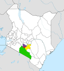 | |
| Major city 3.8 million | ||
| Urban Centres over 200K | ||
| Other major Urban Centres | ||
| Future developments | ||