Narok County
Narok County[2] is a county in Kenya with a population projected at around 1,157,873 persons as of 2019, with the dominant ethnic groups being the Maasai and Kalenjin. Its capital and largest town is Narok. The other major urban centre in Narok County is Kilgoris.[3]
.jpg)
Narok County | |
|---|---|
 Hot Air Balloon Safari in Maasai Mara | |
 Flag | |
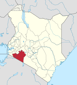 Location in Kenya | |
| Coordinates: 1°15′S 35°37′E | |
| Country | |
| Formed | March 4th 2013 |
| Capital | Narok |
| Government | |
| • Governor | Samwel Tunai |
| Area | |
| • Total | 17,921.2 km2 (6,919.4 sq mi) |
| Population (2019) | |
| • Total | 1,157,873[1] |
| Time zone | UTC+3 (EAT) |
| Website | narok.go.ke |
Narok County is situated in the southern part of the Great Rift Valley. Narok lies between latitudes 0° 50´ and 1° 50´ South and longitude 35° 28′ and 36° 25´ East. The county borders the Republic of Tanzania and six other counties – Nakuru, Bomet, Nyamira, Kisii, Migori County and Kajiado.[4]
The county is rich in terms of nature with the world famous Maasai Mara National Reserve, as well as Mau Forest located within its borders.[3]
The main cash crop grown in Narok County is wheat.
Along with Kisii County, Narok County has been identified as having the highest level of practice of female genital cutting in the country, despite the practice being outlawed in 2001.[5]
County subdivisions
The County has six constituencies:
- Narok North Constituency
- Narok South Constituency
- Narok East Constituency
- Narok West Constituency
- Emurua Dikirr Constituency
- Kilgoris Constituency
| Local authorities (councils) | |||
| Authority | Type | Population* | Urban pop.* |
|---|---|---|---|
| Narok | Town | 41,092 | 24,091 |
| Narok County | County | 324,658 | 2,839 |
| Total | - | 365,750 | 26,930 |
| * 1999 census. Source: | |||
Narok County Wards
There are thirty Members of County Assembly (MCAs) representing the thirty wards at Narok County Assembly. These wards were formed in 2010 by the Boundaries Review Commission. There are six wards in Narok North Constituency, Narok South Constituency and Kilgoris Constituency respectively.
Narok West Constituency, Emurua Dikirr Constituency and Narok East Constituency each have four county wards[6]
- Narok Town
- Olpusimoru
- Olokurto
- Nkareta
- Olorropil
- Melili
- Majimoto/ Narosura
- Ololulung’a
- Melelo
- Loita
- Sogoo
- Sagamian
- Central
- Keyian
- Angata Barikoi
- Shankoe
- Kimintet
- Lolgorian
- Ilmotiok
- Mara
- Siana
- Naikara
- Ilkerin
- Olomasani
- Mogondo
- Kapsasian
- Mosiro
- Ildamat
- Keekonyokie
- Suswa
Population
| Historical population | ||
|---|---|---|
| Year | Pop. | ±% |
| 1979 | 210,306 | — |
| 1989 | 398,272 | +89.4% |
| 1999 | 536,341 | +34.7% |
| 2009 | 850,920 | +58.7% |
| 2019 | 1,157,873 | +36.1% |
| source:[7] | ||
Notable People
- David Rudisha.
- Daniel Matasi Rudisha.[8] Father to David Rudisha, Kenyan Olympic Champion, World Champion and record holder middle-distance runner.
- Kurito Ole Kisio.
References
- "Kenya Census 2009 - Census - Kenya". Scribd. Retrieved 19 April 2018.
- "Welcome to Narok County Government | Kenya". www.narok.go.ke. Retrieved 28 May 2020.
- "Narok County - County Integrated Development Plan 2018-2023". Maarifa Centre. Retrieved 17 October 2019.
- "About Narok County". Narok County Government. Retrieved 30 July 2019.
- BBC News, "Kenyan Girls Flee Circumcision" (on circumcision), BBC News - In Pictures, 2003, webpage: BBC-News-In-Pictures-Kenya.
- "Narok County Wards and Constituencies". http://maasaimedia.com. Retrieved 3 May 2016. External link in
|website=(help) - Kenya: Administrative Division population statistics
- "Rudisha to be buried on Monday". The Star. Retrieved 28 February 2020.