West Pokot County
West Pokot County is a county of Kenya. Its capital and largest town is Kapenguria. The county covers an area of approximately 9,169.4 square kilometers and stretches a distance of 132 kilometers from North to South.[2] West Pokot County is bordered to the north by Turkana County, to the east by Baringo County, to the southeast by Elgeyo-Marakwet County, to the south by Trans Nzoia County and to the west by Uganda. According to the 2019 census, the county has a population of 621,241.[1] The county is home to Tegla Loroupe, one of the most famous Kenyan female runners.
West Pokot County | |
|---|---|
 Flag  Coat of arms | |
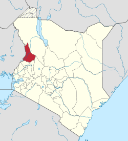 Location in Kenya | |
| Coordinates: 01.23333°N 035.1167°E | |
| Country | |
| Formed | March 4, 2013 |
| Capital | Kapenguria |
| Government | |
| • Governor | John Krop Lonyang'apuo |
| Area | |
| • Total | 8,418.2 km2 (3,250.3 sq mi) |
| Population (2019)[1] | |
| • Total | 621,241 |
| • Density | 74/km2 (190/sq mi) |
| Time zone | UTC+3 (EAT) |
| Website | westpokot.go.ke |
Etymology
Demographics
Pokot people are the main inhabitants of the county and there is also a minority community of Sengwer.[3]
| Historical population | ||
|---|---|---|
| Year | Pop. | ±% |
| 1979 | 158,652 | — |
| 1989 | 225,449 | +42.1% |
| 1999 | 308,086 | +36.7% |
| 2009 | 512,690 | +66.4% |
| 2019 | 621,241 | +21.2% |
| source:[4] | ||
Geography
Mount Mtelo is located in West Pokot County.
Constituencies
County subdivisions
| Local authorities (councils) | |||
| Authority | Type | Population* | Urban pop.* |
|---|---|---|---|
| Kapenguria | Municipality | 56,019 | 12,984 |
| Chepareria | Town | 8,212 | 901 |
| Pokot | County | 243,855 | 0 |
| Total | - | 308,086 | 13,885 |
| * 1999 census. Source:[5] | |||
| Administrative divisions | |||
| Division | Population* | Urban pop.* | Headquarters |
|---|---|---|---|
| Alale | 29,679 | 0 | |
| Chepareria | 68,518 | 900 | Chepareria |
| Chesegon | 21,343 | 0 | |
| Kacheliba | 20,151 | 0 | |
| Kapenguria | 62,746 | 12,438 | Kapenguria |
| Kasei | 9,879 | 0 | |
| Kongelai | 20,018 | 0 | Kongelai |
| Lelan | 32,931 | 0 | |
| Sigor | 42,821 | 0 | Sigor |
| Total | 308,086 | 13,338 | - |
| * 1999 census. Sources[6][7] | |||
The district has four constituencies:
Economy
The West Pokot county economy is principally driven by agriculture and livestock rearing. Some of the main crops grown include maize, a staple ingredient grown mainly in West Pokot Sub-County, as well as finger millet, coffee, beans, onions, sweet potatoes, green grams, peas, mangoes, oranges, bananas, potatoes and pyrethrum. The latter two are mainly grown in South Pokot sub-County.
In Pokot Central and North sub-counties, zebu indicine cattle have long been kept for meat production while in West Pokot and Pokot South sub-counties dairy breeds, primarily Ayrshire and Friesian, are increasingly kept for milk production.[2]
Sport

Infrastructure
Energy
The Turkwel Hydro Power Plant operated by electricity generating company Kengen is situated in West Pokot County. Though the plant produces about 105MW of power which is fed to the national grid, many communities around the power plant and the extensive districts of West Pokot and Turkana do not benefit from this resource.
Notable residents
- Tegla Loroupe, A world record holder for 20, 25 and 30 kilometres long distance track running[8]
- Lonah Chemtai Salpeter, Kenyan-Israeli Olympic marathon runner
2019 Landslide
On the 23rd of November 2019 there was a landslide that has killed over 52 people. At least 22 other people are missing after this disaster, over 22,000 people have been displaced after this disaster.[9]
References
- "2019 Kenya Population and Housing Census Volume I: Population by County and Sub-County". Kenya National Bureau of Statistics. Retrieved 6 November 2019.
- County Government. "West Pokot County Informaion". westpokot.go.ke. County Government of West Pokot. Retrieved 26 September 2019.
- "West Pokot County Integrated Development Plan (CIDP 2018-2022)". Maarifa. Retrieved 2 December 2019.
- Kenya: Administrative Division population statistics
- http://treasury.go.ke/cbs.go.ke/pdf/authority.pdf
- http://www.cck.go.ke/html/final_annex1_cover_status.pdf
- http://www.ilri.cgiar.org/html/Urban%20Poverty%20all%20Kenya%20Province%20through%20Location%20Final.xls
- https://www.biographyonline.net/sport/tegla-loroupe.html
- Death toll from landslides hits 52 - VIDEO, retrieved 3 December 2019
- Muraya, Joseph (20 April 2020). "4,000 displaced by West Pokot mudslides that killed 4 » Capital News". Capital News. Retrieved 25 May 2020.
- "Houses destroyed as fresh landslides hit West Pokot - Kenya". ReliefWeb. Retrieved 25 May 2020.