Viluppuram
Viluppuram(![]()
Vizhuppuram | |
|---|---|
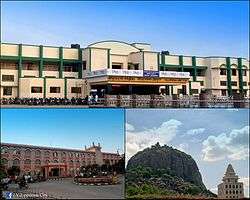 Vizhuppuram Junction, District Court, Gingee Fort | |
 Vizhuppuram Location in Tamil Nadu, India | |
| Coordinates: 11.941°N 79.493°E | |
| Country | |
| State | Tamil Nadu |
| Region | Tondai Nadu |
| District | Vizhuppuram |
| Established | 1919 |
| Government | |
| • Type | Selection Grade Municipality |
| • Body | Vizhuppuram Municipality |
| • Chairman | Vacant |
| Area | |
| • Total | 33.13 km2 (12.79 sq mi) |
| Area rank | 15 |
| Elevation | 44 m (144 ft) |
| Population (2001)[2] | |
| • Total | 96,253 [3] |
| Languages | |
| • Official | Tamil |
| Time zone | UTC+5:30 (IST) |
| PIN | 605601,605602,605401,605103,605301 |
| Telephone code | +91–4146(STD Code) |
| Vehicle registration | TN–32 |
| Distance from Chennai | 160 kilometres (99 mi) |
| Sex ratio | 998 ♂/♀ |
| Climate | Aw(Köppen) |
| Literacy | 90.16% |
| Website | Viluppuram Municipality |
Located 61 kilometres (38 mi) south east of a Tiruvannamalai and 45 kilometres (28 mi) north west of Cuddalore. The city serves as a major railway junction, and National Highway 45 passes through it. With agriculture as its main source of income, As of Government of India 2014 data, Vizhuppuram had a population of 1,40, 714 and the city's literacy rate has been recorded as 90.16% by Census 2011.[5]
In 1919, Vizhuppuram was officially constituted as a municipality, which today comprises 42 wards, making it the largest town and municipality in Vizhuppuram district .
History
In 1677, Shivaji took Gingee area with the assistance of Golkonda forces. Later in 18th century, both the English and French acquired settlements in South Arcot. During the Anglo-French rivalry, the entire district was turned into a war land. After some time, the entire area came under the control of East India Company. It remained under British authority till 1947 when India became independent.[6]
Geography
Vizhuppuram is located in 11° 56' N 79° 29' E.[7] which is in the far southeast part of India, situated 160 kilometres (99 mi) south of Chennai, 160 kilometres (99 mi) north of Trichy, 177 kilometres (110 mi) east of Salem, 40 kilometres (25 mi) west of Pondicherry shares the seashore of the Bay of Bengal.[8]
The area contains metamorphic rocks formed by pressure and heat belonging to the granite-like gneiss family. There are also three major groups of sedimentary rocks, layers of particles that settled in different geological periods.[9] Kalrayan Hills [10] forest park is located 116 kilometres (72 mi) to the west and Gingee Hills forest park 50 kilometres (31 mi) to the north. The Thatagiri Murugan Temple is about 191 kilometres (119 mi) to the southeast in Senthamangalam[11] with the Lord Siva temple in Koppampatti 153 kilometres (95 mi) southwest of the town.[8]
Demographics
| Historical population | ||
|---|---|---|
| Year | Pop. | ±% |
| 1961 | 43,496 | — |
| 1971 | 60,242 | +38.5% |
| 1981 | 77,091 | +28.0% |
| 1991 | 88,788 | +15.2% |
| 2001 | 95,455 | +7.5% |
| 2011 | 96,253 | +0.8% |
| Sources: | ||
As of the 2011 census, Viluppuram municipality was divided into 44 wards for which elections are held every five years and had a population of 96,253 of which 47,670 were male and 48,583 female.[13]
Administration
| Municipality officials | |
|---|---|
| Chairman | Vacant
(Since 2016) |
| Elected members | |
| Member of Legislative Assembly | C. Ve. Shanmugam[14] |
| Member of Parliament | D.Ravikumar[15] |
Politically, Viluppuram is part of the Vizhuppuram Lok Sabha constituency and the Vizhuppuram State Assembly constituency. The municipality was established in 1919 and was upgraded to a second-grade municipality in 1953, the first-grade municipality in 1973, and a selection grade municipality in 1988. It has a population of 145874 (2011 census) and an area of 8.36 square kilometres (3.23 sq mi). The town is divided into 42 wards. The municipal council is composed of 42 ward councilors and is headed by a chairperson elected by voters of the town. Councilors-elect a vice-chairperson among themselves while the executive wing is headed by a commissioner, who is assisted by a team of officials including the health officer, municipal engineer, town planning officer, manager, revenue officer and other staff.
Transport
Road
Viluppuram is connected by roads to major cities and to the rest of the state. The major national highways of the town are:
- NH 45, which connects Chennai to Theni, via Viluppuram – Tiruchirapalli – Dindigul – Periyakulam.[17][18]
- NH 45A, which connects Viluppuram to Nagapattinam via Pondicherry and Cuddalore.[19]
- NH 234, which Connects Villupuram to Mangalore via Thiruvannamalai – Vellore – Gudiyatham.[20]
- NH 45C, which connects (Viluppuram) Vikravandi to Thanjavur via Panruti – Neyveli – Kumbakonam and intersects with NH 45A in Koliyanur, about 5 km from Viluppuram city.[21]
Rail
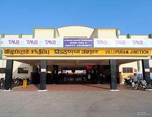
Vizhuppuram has a railway station. It was first built under the British. The Viluppuram Railway Junction at Vizhuppuram serves as the distribution point of rail traffic from Chennai, the state capital of Tamil Nadu, towards the southern part of the state. It is one of the important junctions in Southern Railway.[22][23] Five railway lines branch out of Vizhuppuram:
- Fully Electrified Double BG (Broad Gauge) line (FEDL) towards Chennai Beach via Chengulpattu Junction.[24][25]
- Fully Electrified Double BG (Broad Gauge) line (FEDL) towards Tiruchirapalli Junction via Vridhachalam Junction and Ariyalur. Also called "Chord Line" to Tiruchirapalli.[26][27][28][29]
- Non electrified BG (Broad Gauge) line towards Tiruchirapalli Junction via Cuddalore Port Junction, Mayiladuthurai Junction, Kumbakonam and Thanjavur Junction.Also called Main Line. [30][31]
- Electrified BG (Broad Gauge) line towards Katpadi Junction via Tiruvannamalai and Vellore Cantonment.[32][33]
- Electrified BG (Broad Gauge) line to Pondicherry.[34][35][36]
Air
The nearest airport is Pondicherry Airport[37] at Pondicherry,[38] in Puducherry, approximately 40 km from Viluppuram. Pondicherry Airport is connected to Bangalore by commercial airlines.
The nearest major airport is the Chennai International Airport (MAA), approximately 147 km from the town; the next closest major airport is Tiruchirapalli Airport, approximately 170 km from the town.
Climate
Since the town is landlocked, the weather in Viluppuram is generally humid and hot. It relies on the monsoon for rain during October, November and December. Summers are very hot, and temperatures can get up to 40 °C (104 °F). Winters are moderate with temperatures ranging between 30 and 35 °C (86 and 95 °F) Viluppuram has a tropical climate. In winter, there is much less rainfall in Viluppuram than in summer. This climate is considered to be Aw according to the Köppen-Geiger climate classification.
The average annual temperature is 28.4 °C (83.1 °F) in Viluppuram with average annual rainfall of 1,046 millimetres (41.2 in). The driest month is March, with 6 millimetres (0.24 in) of rainfall. With an average of 222 millimetres (8.7 in) per annum, the most precipitation falls in October. The warmest month of the year is May, with an average temperature of 32.0 °C (89.6 °F). January has the lowest average temperature of the year at 24.6 °C (76.3 °F)
| Climate data for Viluppuram | |||||||||||||
|---|---|---|---|---|---|---|---|---|---|---|---|---|---|
| Month | Jan | Feb | Mar | Apr | May | Jun | Jul | Aug | Sep | Oct | Nov | Dec | Year |
| Average high °C (°F) | 28.8 (83.8) |
30.6 (87.1) |
32.9 (91.2) |
34.7 (94.5) |
37.1 (98.8) |
37.1 (98.8) |
34.5 (94.1) |
34.8 (94.6) |
34.2 (93.6) |
32.0 (89.6) |
29.5 (85.1) |
28.2 (82.8) |
32.9 (91.2) |
| Average low °C (°F) | 20.4 (68.7) |
20.8 (69.4) |
22.7 (72.9) |
25.6 (78.1) |
27.0 (80.6) |
26.9 (80.4) |
25.9 (78.6) |
25.3 (77.5) |
24.9 (76.8) |
22.1 (71.8) |
22.5 (72.5) |
21.2 (70.2) |
23.8 (74.8) |
| Average rainfall mm (inches) | 20 (0.8) |
7 (0.3) |
6 (0.2) |
16 (0.6) |
40 (1.6) |
45 (1.8) |
80 (3.1) |
149 (5.9) |
135 (5.3) |
222 (8.7) |
216 (8.5) |
110 (4.3) |
1,046 (41.1) |
| Source: en.climate-data.org,[39] | |||||||||||||
The difference in precipitation between the driest month and the wettest month is 216 millimetres (8.5 in). During the year, the average temperatures vary by 7.4 °C (45.3 °F).
References
- "Area-wise Population within corporations and municipalities in Tamil Nadu" (XLS). Government Of India. p. 2. Retrieved 13 February 2014.
- "Area-wise Population within corporations and municipalities in Tamil Nadu" (XLS). Government Of India. p. 2. Retrieved 13 February 2014.
- "Census Info 2011 Final population totals – Viluppuram". Office of The Registrar General and Census Commissioner, Ministry of Home Affairs, Government of India. 2013. Retrieved 26 January 2014.
- "Viluppuram, not Villupuram". The Hindu. Retrieved 16 July 2015.
- "Viluppuram Census 2011".
- "History of Viluppuram". Viluppuram Municipality.
- "Imperial Gazetteer of India ..." google.com.
- {{cite and web|url=https://www.google.com/maps/place/Villupuram,+Tamil+Nadu,+India/@11.9766285,79.3158042,10z/data=!3m1!4b1!4m2!3m1!1s0x3a5356ebd4449db7:0xe06a76a0bf5f11a9|title=Google Maps|work=Google Maps}}
- "TAMILNADU WATER SUPPLY AND DRAINAGE BOARD". twadboard.gov.in.
- "Pachaimalai Hills". Encyclopædia Britannica. Encyclopædia Britannica Online. 2007. Retrieved 15 March 2007.
- "Census of India 2001: Data from the 2001 Census, including cities, villages and towns (Provisional)". Census Commission of India. Archived from the original on 16 June 2004. Retrieved 1 November 2008.
- "historic population" (PDF).
- "Viluppuram Municipality City Population Census 2011-2019". www.census2011.co.in. Retrieved 21 May 2019.
- "MLA of Viluppuram". Government of Tamil Nadu. 2011. Retrieved 16 November 2012.
- "Members of Lok Sabha from Tamil Nadu". Government of Tamil Nadu. 2014. Retrieved 26 May 2014.
- "Viluppuram Religion Data 2011". Census 2011. 2011.
- "Chennai-Trichy Six Lane Upgrade". The Hindu. Retrieved 15 July 2014.
- "NH 45 Highly Prone to Accidents". The Hindu. Retrieved 4 January 2014.
- "Villupuram- Nagapattinam Narrow Highway". The Hindu. Retrieved 23 June 2009.
- "Villupuram- Mangaluru National Highway". The Times Of India. Retrieved 26 April 2010.
- "Vikravandi – Thanjavur un-shape highway". Indian Express. Retrieved 21 April 2008.
- "Indianrailinfo – Viluppuram Junction Departures". Indianrailinfo. Retrieved 5 July 2014.
- "Origins and history of Southern Railway" (PDF). Retrieved 14 February 2015.
- R. Rajaram. "More BG sections to be electrified". The Hindu, 20 April 2011. Retrieved 7 January 2014.
- "Villupuram District at a Glance". Villupuram district administration. Archived from the original on 26 December 2013. Retrieved 7 January 2014.
- "Electrification work from Villupuram to Tiruchi completed: E. Ahamed". The Hindu. 12 January 2010. Retrieved 1 January 2014.
- R.Rajaram (10 July 2010). "Tiruchi-Chennai line to get decongested". The Hindu. Retrieved 1 January 2014.
- "Doubling work on 25-km stretch completed in Trichy division". The Times of India. 16 May 2013. Retrieved 1 January 2014.
- "Kallakudi Palanganatham-Ariyalur railway line nearing completion". The Hindu. 16 August 2013. Retrieved 1 January 2014.
- "IR History: Early Days – I". Chronology of railways in India, Part 2 (1832 – 1865). Retrieved 3 January 2014.
- "IR History: Early Days – II". Chronology of railways in India, Part 2 (1870 – 1899). Retrieved 3 January 2014.
- "Passengers seek shuttle train in Villupuram-Katpadi section". The Hindu. Retrieved 27 August 2013.
- "Special trains between Katpadi and Villupuram". The Hindu. Retrieved 8 February 2012.
- "Residents demand railway station". Puducherry. The Hindu. 6 January 2009. Retrieved 14 April 2013.
- C., Jaisankar (27 February 2013). "A dream-come-true Railway budget: Union Minister". Puducherry. The Hindu. Retrieved 14 April 2013.
- "Bomb scare at railway station". Puducherry. The Hindu. 3 February 2013. Retrieved 14 April 2013.
- "Puducherry airport to go on stream in October". The Economic Times. 3 September 2011. Retrieved 3 January 2012.
- "Flight operations await new terminal". IBN Live. 10 May 2012. Retrieved 3 July 2012.
- "Climate:Viluppuram". Retrieved 4 January 2014.
External links
| Wikimedia Commons has media related to Viluppuram. |
| State symbols |
| |
|---|---|---|
| Governance |
| |
| Topics | ||
| Major cities | ||
| Districts |
| |
| Lists | ||
| Authority control |
|
|---|