Vaudreuil-Soulanges Regional County Municipality
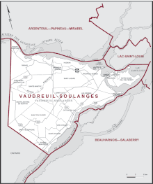
Vaudreuil-Soulanges is a regional county municipality in Quebec, Canada. It is located on a triangular peninsula in the western Montérégie region of Quebec, formed by the confluence of the Ottawa River to the north, and the St. Lawrence River to the south. Ontario is located west of here.
Vaudreuil-Soulanges | |
|---|---|
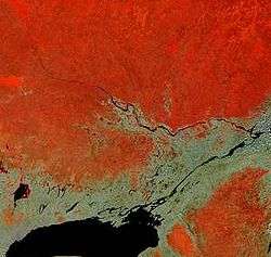 Vaudreuil-Soulanges is at the triangle (centre right) formed west of the confluence of the Ottawa and Saint Lawrence River rivers in this satellite image. | |
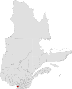 Location in province of Quebec. | |
| Coordinates: 45°21′N 74°13′W[1] | |
| Country | |
| Province | |
| Region | Montérégie |
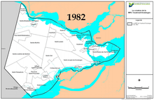
| Effective | April 14, 1982 |
| County seat | Vaudreuil-Dorion |
| Government | |
| • Type | Prefecture |
| • Prefect | Robert Sauvé |
| Area | |
| • Total | 1,019.70 km2 (393.71 sq mi) |
| • Land | 855.56 km2 (330.33 sq mi) |
| Population (2016)[3] | |
| • Total | 149,349 |
| • Density | 174.6/km2 (452/sq mi) |
| • Change 2011-2016 | |
| • Dwellings | 59,474 |
| Time zone | UTC−5 (EST) |
| • Summer (DST) | UTC−4 (EDT) |
| Area code(s) | 450 and 579 |
| Website | www |
Geography
Vaudreuil-Soulanges is part of the St Lawrence Valley. Two million years ago the region was subject to a series of glaciations that covered much of North America. The last in the series was the Wisconsin glaciation. The ice sheet weighed down the landscape. This created the depressions in the land that created the basins for Lake Saint-Louis, Lac des Deux-Montagnes and Lake Saint-Francis. As the ice sheet eroded, the region was mostly submerged 12,000 years ago by an inland saltwater sea known as the Champlain sea. Once the glacier was melted, the land rose again, pushing the saltwater into the sea. 10,000 years ago the body of water, now a fresh water lake, has been named by scholars as Lake Lampsilis.
History
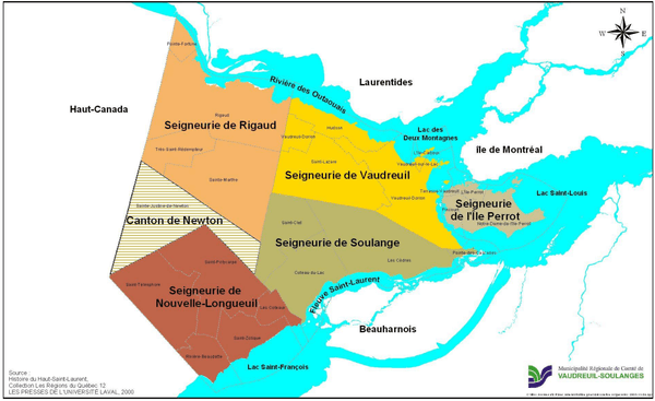
During the French colonial period, the region of New France was divided into several seigneuries populated by French colonists. [4]
- Seigneurie de L'Île-Perrot founded on October 29th 1672 (modern day L'Île-Perrot, Pincourt, Notre-Dame-de-L'Île-Perrot and Terrasse-Vaudreuil)[5][6]
- Seigneurie de Vaudreuil founded on October 12th 1702 (modern day Vaudreuil-Dorion, Vaudreuil-sur-le-Lac, L'Île-Cadieux, Saint-Lazare and Hudson[7][8]
- Seigneurie de Soulanges founded on October 12th 1702 (modern day Saint-Clet, Coteau-du-Lac, Les Cèdres and Pointe-des-Cascades)[9][10]
- Seigneurie de Rigaud founded on October 29th 1732 (modern day Rigaud, Sainte-Marthe, Pointe-Fortune and Très-Saint-Rédempteur)[11][12]
- Seigneurie de Nouvelle-Longueuil founded on April 21 1734 (modern day Saint-Polycarpe, Saint-Télesphore, Saint-Zotique, Les Coteaux et Rivière-Beaudette)[13][14]
- Canton Newton founded in August 1791 (modern day Sainte-Justine-de-Newton, not part of the seigneurie system, was modeled after British township system)[15][16]
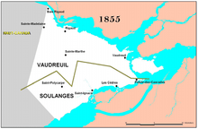
The seigneurial system was finally abolished in 1854, nearly a century after Great Britain took over the territory after defeating France in the Seven Years' War.
It is the only county in Quebec that is south of the Ottawa River. Great Britain wanted to keep most of the French-speaking, ethnic French population of the area within Lower Canada during the 1791 division of Upper and Lower Canada (precursors to the provinces of Ontario and Quebec). It is geographically isolated from the Montérégie region, as it is its only county located north of the St. Lawrence River.
The name relates to the historical division of the area into two counties: Vaudreuil County -- (named after Pierre François de Rigaud, Marquis de Vaudreuil-Cavagnal, governor of New France) for the communities along the Ottawa River, and Soulanges County -- (named after Pierre-Jacques Joybert de Soulanges from Soulanges, Marne, France) for the communities along the St. Lawrence. Soulanges is a name of Québécois derivation, referring to its southerliness.
Since the RCM formation on 14 April 1982, the division of the county into "Vaudreuil" and "Soulanges" is still salient. The "Vaudreuil" area (consisting of the municipalities of Vaudreuil-Dorion, Saint-Lazare, Hudson, L'Île-Perrot, and others) is closer to Montreal. It is more suburban, populous, and economically and ethnically diverse. By contrast, the Soulanges area (including the municipalities of Saint-Polycarpe, Saint-Zotique, Coteau-du-Lac, Rivière-Beaudette and Les Coteaux) is predominantly rural, agricultural, and ethnically French-Canadian.
Owing to the county's geographic isolation within Quebec, and its growing population as a suburb of the city of Montreal, Elections Canada assigned the electoral district to the county in 1997.
Subdivisions
There are 23 subdivisions within the RCM:[2]
|
|
|
|
Demographics
Population
| Canada census – Vaudreuil-Soulanges Regional County Municipality community profile | |||
|---|---|---|---|
| 2016 | 2011 | 2006 | |
| Population: | 149,349 (+7.2% from 2011) | 139,353 (+15.7% from 2006) | 120,935 (+17.9% from 2001) |
| Land area: | 855.36 km2 (330.26 sq mi) | 855.36 km2 (330.26 sq mi) | 854.84 km2 (330.06 sq mi) |
| Population density: | 174.6/km2 (452/sq mi) | 162.9/km2 (422/sq mi) | 140.8/km2 (365/sq mi) |
| Median age: | 40.7 (M: 40.3, F: 40.7) | 39.2 (M: 38.9, F: 39.5) | 38.3 (M: 38.0, F: 38.6) |
| Total private dwellings: | 59,474 | 55,203 | |
| Median household income: | $71,095 | $71,095 | |
| References: 2016[17] 2011[18] 2006[19] earlier[20] | |||
| Historical Census Data - Vaudreuil-Soulanges Regional County Municipality, Quebec | |||||||||||||||||||||||||||||
|---|---|---|---|---|---|---|---|---|---|---|---|---|---|---|---|---|---|---|---|---|---|---|---|---|---|---|---|---|---|
|
|
| |||||||||||||||||||||||||||
| [21][22][3] | |||||||||||||||||||||||||||||
Population History by County (1855-1982)
| Municipality | 1871 | 1881 | 1891 | 1901 | 1911 | 1921 | 1931 | 1941 | 1951 | 1956 | 1961 | 1966 | 1971 | 1976 | 1981 |
|---|---|---|---|---|---|---|---|---|---|---|---|---|---|---|---|
| Comté de Vaudreuil | 11,003 | 11,485 | 10,792 | 10,445 | 11,039 | 11,555 | 12,015 | 13,170 | 17,378 | 22,625 | 28,681 | 34,053 | 36,593 | 44,257 | 50,043 |
| Comté de Soulanges | 10,808 | 10,220 | 9,608 | 9,928 | 9,400 | 10,065 | 9,099 | 9,328 | 9,233 | 9,736 | 10,075 | 10,757 | 11,449 | 13,254 | 15,429 |
| Vaudreuil-Soulanges | 21,811 | 21,705 | 20,400 | 20,373 | 20,439 | 21,620 | 21,114 | 22,498 | 26,611 | 32,361 | 38,756 | 44,810 | 48,042 | 57,511 | 65,472 |
Population History by Municipality
| Municipality | 1986 | 1991 | 1996 | 2001 | 2006 | 2011 | 2016 |
|---|---|---|---|---|---|---|---|
| Vaudreuil-Dorion | 13,722 | 17,109 | 18,466 | 20,650 | 25,789 | 33,305 | 38,117 |
| Saint-Lazare | 5,065 | 9,055 | 11,193 | 12,895 | 17,016 | 19,215 | 19,889 |
| Pincourt | 9,121 | 9,749 | 10,023 | 10,155 | 11,197 | 14,305 | 14,558 |
| L'Île-Perrot | 6,586 | 8,065 | 9,178 | 9,063 | 9,927 | 10,503 | 10,756 |
| Notre-Dame-de-l'Île-Perrot | 4,325 | 5,261 | 7,059 | 8,737 | 9,885 | 10,620 | 10,654 |
| Saint-Zotique | 2,025 | 2,515 | 3,683 | 4,158 | 5,251 | 6,773 | 7,934 |
| Rigaud | 4,928 | 5,770 | 6,057 | 6,095 | 6,780 | 7,346 | 7,777 |
| Coteau-du-Lac | 3,550 | 4,193 | 4,960 | 5,684 | 6,346 | 6,842 | 7,044 |
| Les Cèdres | 3,320 | 3,836 | 4,641 | 5,128 | 5,732 | 6,079 | 6,777 |
| Les Coteaux | 2,290 | 2,613 | 2,843 | 3,297 | 3,764 | 4,568 | 5,368 |
| Hudson | 4,425 | 4,829 | 4,796 | 4,811 | 5,088 | 5,135 | 5,185 |
| Saint-Polycarpe | 1,570 | 1,640 | 1,676 | 1,660 | 1,708 | 1,969 | 2,224 |
| Rivière-Beaudette | 1,045 | 1,292 | 1,381 | 1,464 | 1,720 | 1,885 | 2,097 |
| Terrasse-Vaudreuil | 1,665 | 1,744 | 1,977 | 2,061 | 1,985 | 1,971 | 1,986 |
| Saint-Clet | 1,125 | 1,388 | 1,524 | 1,613 | 1,725 | 1,738 | 1,779 |
| Pointe-des-Cascades | 640 | 691 | 910 | 981 | 1,046 | 1,340 | 1,481 |
| Vaudreuil-sur-le-Lac | 675 | 876 | 928 | 964 | 1,290 | 1,359 | 1,341 |
| Sainte-Marthe | 1,055 | 1,056 | 1,090 | 1,094 | 1,080 | 1,075 | 1,097 |
| Sainte-Justine-de-Newton | 860 | 926 | 934 | 888 | 929 | 973 | 922 |
| Très-Saint-Rédempteur | 480 | 570 | 622 | 598 | 733 | 863 | 898 |
| Saint-Télesphore | 780 | 772 | 805 | 809 | 769 | 762 | 759 |
| Pointe-Fortune | 400 | 413 | 451 | 429 | 507 | 542 | 580 |
| L'Île-Cadieux | 115 | 140 | 121 | 127 | 128 | 105 | 126 |
| Vaudreuil-Soulanges | 69,767 | 84,503 | 95,318 | 103,361 | 120,395 | 137,429 | 149,349 |
Language
| Canada Census Mother Tongue - Vaudreuil-Soulanges Regional County Municipality, Quebec[21][22][3] | ||||||||||||||||||
|---|---|---|---|---|---|---|---|---|---|---|---|---|---|---|---|---|---|---|
| Census | Total | French |
English |
French & English |
Other | |||||||||||||
| Year | Responses | Count | Trend | Pop % | Count | Trend | Pop % | Count | Trend | Pop % | Count | Trend | Pop % | |||||
2016 |
148,605 |
96,365 | 64.85% | 32,525 | 21.89% | 2,815 | 1.89% | 15,120 | 10.17% | |||||||||
2011 |
137,590 |
93,300 | 67.81% | 30,380 | 22.08% | 2,465 | 1.79% | 11,445 | 8.32% | |||||||||
2006 |
119,465 |
85,565 | 71.62% | 24,760 | 20.73% | 1,515 | 1.27% | 7,625 | 6.38% | |||||||||
2001 |
101,290 |
76,610 | 75.63% | 19,615 | 19.37% | 1,275 | 1.26% | 3,790 | 3.74% | |||||||||
1996 |
94,370 |
70,690 | n/a | 74.91% | 19,285 | n/a | 20.44% | 1,165 | n/a | 1.23% | 3,230 | n/a | 3.42% | |||||
Transportation
Public Transportation
The region is served by the Exo La Presqu’Île and Exo Sud-Ouest bus services as well as the Vaudreuil-Hudson commuter rail line.
Access Routes
Highways and numbered routes that run through the municipality, including external routes that start or finish at the county border:[25]
|
|
|
|
References
- Reference number 141033 of the Commission de toponymie du Québec (in French)
- Geographic code 710 in the official Répertoire des municipalités (in French)
- "Census Profile, 2016 Census: Vaudreuil-Soulanges, Municipalité régionale de comté [Census division], Quebec". Statistics Canada. Retrieved November 26, 2019.
- http://www.chlapresquile.qc.ca/histo/rubriques-historiques.html
- http://www.archivesvs.org/histo/rubriques-historiques/perrot.html. Missing or empty
|title=(help) - fr:Seigneurie de l'Île-Perrot
- http://www.archivesvs.org/histo/rubriques-historiques/vaudreuil.html. Missing or empty
|title=(help) - fr:Seigneurie de Vaudreuil
- http://www.archivesvs.org/histo/rubriques-historiques/soulanges.html. Missing or empty
|title=(help) - fr:Seigneurie de Soulanges
- http://www.archivesvs.org/histo/rubriques-historiques/rigaud.html. Missing or empty
|title=(help) - fr:Seigneurie de Rigaud
- http://www.archivesvs.org/histo/rubriques-historiques/nouvelle-longueuil.html. Missing or empty
|title=(help) - fr:Seigneurie de Nouvelle-Longueuil
- http://www.archivesvs.org/histo/rubriques-historiques/newton.html. Missing or empty
|title=(help) - fr:Sainte-Justine-de-Newton
- "2016 Community Profiles". 2016 Canadian Census. Statistics Canada. February 21, 2017. Retrieved 2018-03-04.
- "2011 Community Profiles". 2011 Canadian Census. Statistics Canada. July 5, 2013. Retrieved 2014-01-27.
- "2006 Community Profiles". 2006 Canadian Census. Statistics Canada. March 30, 2011.
- "2001 Community Profiles". 2001 Canadian Census. Statistics Canada. February 17, 2012.
- Statistics Canada: 1996, 2001, 2006, 2011 census
- "(Code 2471) Census Profile". 2011 census. Statistics Canada. 2012.
- a.
b.
c.
d.
e. - a. Statistique Canada, Recensement de la population de 1996, Profil des divisions et subdivisions de recensement : Vaudreuil-Soulanges, produit 95F0181XDB96001 au catalogue de Statistique Canada. Consulté le 20 juillet 2017.
b. Statistique Canada. 2002. Profils des communautés de 2001. Vaudreuil-Soulanges (Code 2471), Ottawa. No 93F0053XIF au catalogue de Statistique Canada. Diffusé le 27 juin 2002; modifié le 30 novembre 2005. Consulté le 20 juillet 2017.
c. Statistique Canada. 2007. Profils des communautés de 2006, Recensement de 2006 (Code 2471) (Hiérarchie)., produit nº 92-591-XWF au catalogue de Statistique Canada. Ottawa. Diffusé le 13 mars 2007. Consulté le 20 juillet 2017.
d. Statistique Canada. Profil du recensement, produit nº 98-316-XWF au catalogue de Statistique Canada. Ottawa. Vaudreuil-Soulanges (Code 2471) Géographie hiérarchie. 2011, diffusé le 24 octobre 2012. Consulté le 20 juillet 2017.
e. Statistique Canada. 2017. Hiérachie, Vaudreuil-Soulanges, MRC (Division de recensement 2471). Profil du recensement, Recensement de 2016, produit nº 98-316-X2016001 au catalogue de Statistique Canada. Ottawa. Diffusé le 3 mai 2017. (site consulté le 20 juillet 2017). - Official Transport Quebec Road Map
Adjacent Counties & Equivalent Territories | |
|---|---|