Rivière-Beaudette, Quebec
Rivière-Beaudette is a municipality of Quebec, Canada, located in the southwest corner of the Vaudreuil-Soulanges Regional County Municipality on the border with Ontario along the Saint Lawrence River. The population as of the Canada 2011 Census was 1,885.
Rivière-Beaudette | |
|---|---|
Municipality | |
 | |
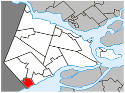 Location within Vaudreuil-Soulanges RCM. | |
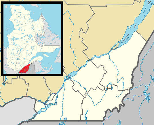 Rivière-Beaudette Location in southern Quebec. | |
| Coordinates: 45°14′N 74°20′W[1] | |
| Country | |
| Province | |
| Region | Montérégie |
| RCM | Vaudreuil-Soulanges |
| Constituted | 17 January 1990 |
| Government | |
| • Mayor | Patrick Bousez |
| • Federal riding | Salaberry—Suroît |
| • Prov. riding | Soulanges |
| Area | |
| • Total | 25.30 km2 (9.77 sq mi) |
| • Land | 18.51 km2 (7.15 sq mi) |
| Population (2011)[4] | |
| • Total | 1,885 |
| • Density | 101.9/km2 (264/sq mi) |
| • Pop 2006-2011 | |
| • Dwellings | 894 |
| Time zone | UTC−5 (EST) |
| • Summer (DST) | UTC−4 (EDT) |
| Postal code(s) | J0P 1R0 |
| Area code(s) | 450 and 579 |
| Highways | |
| Website | www |
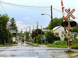
The area is primarily made up of farmland with residential development along the St. Lawrence River.
Demographics
Population
| Canada census – Rivière-Beaudette, Quebec community profile | |||
|---|---|---|---|
| 2011 | 2006 | ||
| Population: | 1,885 (+9.6% from 2006) | 1,720 (+17.5% from 2001) | |
| Land area: | 18.51 km2 (7.15 sq mi) | 18.47 km2 (7.13 sq mi) | |
| Population density: | 101.9/km2 (264/sq mi) | 93.1/km2 (241/sq mi) | |
| Median age: | 43.5 (M: 44.3, F: 41.8) | 43.2 (M: 43.8, F: 42.9) | |
| Total private dwellings: | 894 | 814 | |
| Median household income: | $63,336 | $40,777 | |
| References: 2011[4] 2006[5] earlier[6] | |||
| Historical Census Data - Rivière-Beaudette, Quebec[7] | ||||||||||||||||||||||||||
|---|---|---|---|---|---|---|---|---|---|---|---|---|---|---|---|---|---|---|---|---|---|---|---|---|---|---|
|
|
| ||||||||||||||||||||||||
Language
| Canada Census Mother Tongue - Rivière-Beaudette, Quebec[7] | ||||||||||||||||||
|---|---|---|---|---|---|---|---|---|---|---|---|---|---|---|---|---|---|---|
| Census | Total | French |
English |
French & English |
Other | |||||||||||||
| Year | Responses | Count | Trend | Pop % | Count | Trend | Pop % | Count | Trend | Pop % | Count | Trend | Pop % | |||||
2011 |
1,860 |
1,600 | 86.02% | 170 | 9.14% | 30 | 1.61% | 60 | 3.23% | |||||||||
2006 |
1,695 |
1,480 | 87.32% | 190 | 11.21% | 0 | 0.00% | 25 | 1.47% | |||||||||
2001 |
1,440 |
1,340 | 93.06% | 85 | 5.90% | 15 | 1.04% | 0 | 0.00% | |||||||||
1996 |
1,350 |
1,150 | n/a | 85.19% | 150 | n/a | 11.1% | 20 | n/a | 1.48% | 30 | n/a | 2.22% | |||||
Education
Commission Scolaire des Trois-Lacs operates Francophone schools.[8]
Lester B. Pearson School Board operates Anglophone schools.[9]
- Soulanges Elementary School in Saint-Télesphore or Evergreen Elementary and Forest Hill Elementary (Junior Campus and Senior campus) in Saint-Lazare
See also
References
- Reference number 248141 of the Commission de toponymie du Québec (in French)
- Ministère des Affaires municipales, des Régions et de l'Occupation du territoire: Rivière-Beaudette
- Parliament of Canada Federal Riding History: VAUDREUIL--SOULANGES (Quebec)
- "2011 Community Profiles". 2011 Canadian Census. Statistics Canada. 5 July 2013. Retrieved 7 February 2014.
- "2006 Community Profiles". 2006 Canadian Census. Statistics Canada. 30 March 2011. Retrieved 7 February 2014.
- "2001 Community Profiles". 2001 Canadian Census. Statistics Canada. 17 February 2012.
- Statistics Canada: 1996, 2001, 2006, 2011 census
- "Les écoles et les centres". Commission Scolaire des Trois-Lacs. Retrieved 18 January 2013.
- "School Board Map." Lester B. Pearson School Board. Retrieved on 28 September 2017.
Adjacent Municipal Subdivisions | ||||||||||
|---|---|---|---|---|---|---|---|---|---|---|
| ||||||||||
| Cities & towns | |
|---|---|
| Municipalities | |
| Villages | |
| |
This article is issued from Wikipedia. The text is licensed under Creative Commons - Attribution - Sharealike. Additional terms may apply for the media files.