Saint Lawrence River
The Saint Lawrence River (French: Fleuve Saint-Laurent; Tuscarora: Kahnawáʼkye;[3] Mohawk: Kaniatarowanenneh, meaning "big waterway") is a large river in the middle latitudes of North America. The Saint Lawrence River flows in a roughly north-easterly direction, connecting the Great Lakes with the Atlantic Ocean and forming the primary drainage outflow of the Great Lakes Basin. It traverses the Canadian provinces of Quebec and Ontario, and is part of the international boundary between Ontario, Canada, and the U.S. state of New York. This river provides the basis for the commercial Saint Lawrence Seaway.
| Saint Lawrence River Fleuve Saint-Laurent, Fleuve St-Laurent, St-Lawrence River, St-Laurent River, St. Lawrence Seaway | |
|---|---|
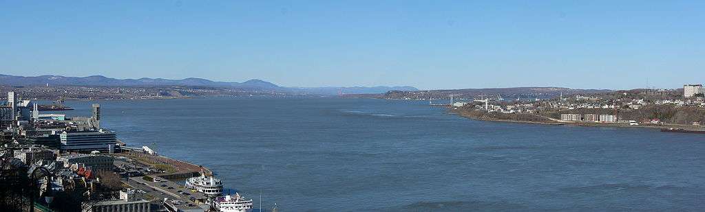
.jpg) Saint Lawrence River in Montreal | |
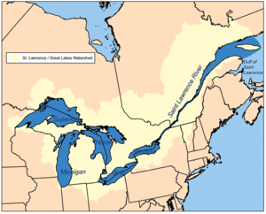 Map of the Saint Lawrence/Great Lakes Watershed | |
| Etymology | Saint Lawrence of Rome |
| Location | |
| Country | Canada, United States |
| Provinces | Ontario, Quebec |
| State | New York |
| Physical characteristics | |
| Source | Lake Ontario |
| ⁃ location | Kingston, Ontario / Cape Vincent, New York |
| ⁃ coordinates | 44°06′N 76°24′W |
| ⁃ elevation | 74.7 m (245 ft) |
| Mouth | Gulf of St. Lawrence / Atlantic Ocean |
⁃ location | Quebec, Canada |
⁃ coordinates | 49°30′N 64°30′W |
⁃ elevation | 0 m (0 ft) |
| Length | 500 km (310 mi)Excluding the estuary. Ca. 1200 km if included. |
| Basin size | 1,344,200 km2 (519,000 sq mi)[1] |
| Discharge | |
| ⁃ location | below the Saguenay River[2] |
| ⁃ average | 16,800 m3/s (590,000 cu ft/s)[2] |
Geography
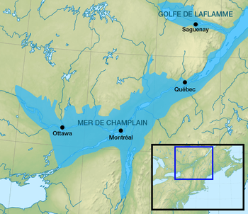
With the draining of the Champlain Sea, due to a rebounding continent from the Last Glacial Maximum, the Saint Lawrence River was formed. The Champlain Sea lasted from about 13,000 years ago to about 10,000 years ago and was continuously shrinking during that time, a process that continues today.[4][5]
Today, the Saint Lawrence River begins at the outflow of Lake Ontario and flows adjacent to Gananoque, Brockville, Morristown, Ogdensburg, Massena, Cornwall, Montreal, Trois-Rivières, and Quebec City before draining into the Gulf of Saint Lawrence, the largest estuary in the world.[6] The estuary begins at the eastern tip of Île d'Orléans, just downstream from Quebec City.[2] The river becomes tidal around Quebec City.[7]
The Saint Lawrence River runs 3,058 kilometres (1,900 mi) from the farthest headwater to the mouth and 1,197 km (743.8 mi) from the outflow of Lake Ontario. These numbers include the estuary; without the estuary the length from Lake Ontario is ca. 500 km (ca. 300 mi). The farthest headwater is the North River in the Mesabi Range at Hibbing, Minnesota. Its drainage area, which includes the Great Lakes, the world's largest system of freshwater lakes, is 1,344,200 square kilometres (518,998.5 sq mi), of which 839,200 km2 (324,016.9 sq mi) is in Canada and 505,000 km2 (194,981.6 sq mi) is in the United States. The basin covers parts of Ontario and Quebec in Canada, parts of Illinois, Indiana, Minnesota, New York, Ohio, Pennsylvania, Vermont, and Wisconsin, and nearly the entirety of the state of Michigan in the United States. The average discharge below the Saguenay River is 16,800 cubic metres per second (590,000 cu ft/s). At Quebec City, it is 12,101 m3/s (427,300 cu ft/s). The average discharge at the river's source, the outflow of Lake Ontario, is 7,410 m3/s (262,000 cu ft/s).[2]
The Saint Lawrence River includes Lake Saint-Louis south of Montreal, Lake Saint Francis at Salaberry-de-Valleyfield and Lac Saint-Pierre east of Montreal. It encompasses four archipelagoes: the Thousand Islands chain near Alexandria Bay, New York and Kingston, Ontario; the Hochelaga Archipelago, including the Island of Montreal and Île Jésus (Laval); the Lake St. Pierre Archipelago (classified biosphere world reserve by the UNESCO in 2000)[8] and the smaller Mingan Archipelago. Other islands include Île d'Orléans near Quebec City and Anticosti Island north of the Gaspé. It is the second longest river in Canada.
Lake Champlain and the Ottawa, Richelieu, Saint-Maurice, Saint-François, Chaudière and Saguenay rivers drain into the Saint Lawrence.
The Saint Lawrence River is in a seismically active zone where fault reactivation is believed to occur along late Proterozoic to early Paleozoic normal faults related to the opening of the Iapetus Ocean. The faults in the area are rift-related and comprise the Saint Lawrence rift system.
According to the United States Geological Survey, the Saint Lawrence Valley is a physiographic province of the larger Appalachian division, containing the Champlain and Northern physiographic section.[9] However, in Canada, where most of the valley is, it is instead considered part of a distinct Saint Lawrence Lowlands physiographic division, and not part of the Appalachian division at all.[10]
History
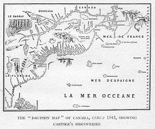
The Norse explored the Gulf of Saint Lawrence in the 11th century and were followed by fifteenth and early sixteenth century European mariners, such as John Cabot, and the brothers Gaspar and Miguel Corte-Real. The first European explorer known to have sailed up the Saint Lawrence River itself was Jacques Cartier. At that time, the land along the river was inhabited by the St. Lawrence Iroquoians; at the time of Cartier's second voyage in 1535. Because Cartier arrived in the estuary on Saint Lawrence's feast day, he named it the Gulf of Saint Lawrence.[11] The Saint Lawrence River is partly within the U.S. and as such is that country's sixth oldest surviving European place-name.[12]
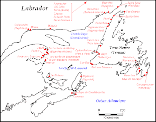
The earliest regular Europeans in the area were the Basques, who came to the St Lawrence Gulf and River in pursuit of whales from the early 16th century. The Basque whalers and fishermen traded with indigenous Americans and set up settlements, leaving vestiges all over the coast of eastern Canada and deep into the Saint Lawrence River. Basque commercial and fishing activity reached its peak before the Armada Invencible's disaster (1588), when the Spanish Basque whaling fleet was confiscated by King Philip II of Spain and largely destroyed. Initially, the whaling galleons from Labourd were not affected by the Spanish defeat.
Until the early 17th century, the French used the name Rivière du Canada to designate the Saint Lawrence upstream to Montreal and the Ottawa River after Montreal. The Saint Lawrence River served as the main route for European exploration of the North American interior, first pioneered by French explorer Samuel de Champlain.
Control of the river was crucial to British strategy to capture New France in the Seven Years' War. Having captured Louisbourg in 1758, the British sailed up to Quebec the following year thanks to charts drawn up by James Cook. British troops were ferried via the Saint Lawrence to attack the city from the west, which they successfully did at the Battle of the Plains of Abraham. The river was used again by the British to defeat the French siege of Quebec under the Chevalier de Lévis in 1760.
In 1809, the first steamboat to ply its trade on the St. Lawrence was built and operated by John Molson and associates, a scant two years after Fulton's steam-powered navigation of the Hudson River. The Accommodation with ten passengers made her maiden voyage from Montreal to Quebec City in 66 hours, for 30 of which she was at anchor. She had a keel of 75 feet, and length overall of 85 feet. The cost of a ticket as eight dollars upstream, and nine dollars down. She had berths that year for twenty passengers.[13]
Within a decade, daily service was available in the hotly-contested Montreal-Quebec route.[14]
Because of the virtually impassable Lachine Rapids, the Saint Lawrence was once continuously navigable only as far as Montreal. Opened in 1825, the Lachine Canal was the first to allow ships to pass the rapids. An extensive system of canals and locks, known as the Saint Lawrence Seaway, was officially opened on 26 June 1959 by Elizabeth II (representing Canada) and President Dwight D. Eisenhower (representing the United States). The Seaway (including the Welland Canal) now permits ocean-going vessels to pass all the way to Lake Superior.
During the Second World War, the Battle of the St. Lawrence involved submarine and anti-submarine actions throughout the lower Saint Lawrence River and the entire Gulf of Saint Lawrence, Strait of Belle Isle and Cabot Strait from May to October 1942, September 1943, and again in October and November 1944. During this time, German U-boats sank several merchant marine ships and three Canadian warships.
In the late 1970s, the river was the subject of a successful ecological campaign (called "Save the River"), originally responding to planned development by the United States Army Corps of Engineers. The campaign was organized, among others, by Abbie Hoffman.[15]
Resident whales

- Beluga whale (Near Threatened)
- Sperm whale (Vulnerable)
- Minke whale
- Fin whale (Endangered)
- Blue whale (Endangered)
- Northern bottlenose whale
- Northern Atlantic right whale (now rarer due to Endangered status, but increasing in St. Lawrence regions since in 1995 or 1998[16])[17][18][19][20]
- Bowhead whale (very occasionally, historically common)
- North Atlantic gray whale (Extinct)[21]
- Humpback whale
Sources
The source of the North River in the Mesabi Range in Minnesota (Seven Beaver Lake) is considered to be the source of the Saint Lawrence River. Because it crosses so many lakes, the water system frequently changes its name. From source to mouth, the names are:
- North River[22]
- Saint Louis River[23]
- Lake Superior
- Saint Marys River
- Lake Huron
- Saint Clair River
- Lake Saint Clair
- Detroit River
- Lake Erie
- Niagara River
- Lake Ontario
The Saint Lawrence River also passes through Lake Saint-Louis and Lake Saint-Pierre in Quebec.
Works
The Saint Lawrence River is at the heart of many Quebec novels (Anne Hébert's Kamouraska, Réjean Ducharme's L'avalée des avalés), poems (in works of Pierre Morency, Bernard Pozier), and songs (Leonard Cohen's "Suzanne", Michel Rivard's "L'oubli", Joe Dassin's "Dans les yeux d'Émilie"), and André Gagnon's "Le Saint-Laurent"). The river was the setting for the Canadian television drama series Seaway. The river has also been portrayed in paintings, notably by the Group of Seven. In addition, the river is the namesake of Saint-Laurent Herald at the Canadian Heraldic Authority.
In 1980 Jacques Cousteau traveled to Canada to make two films on the Saint Lawrence River and the Great Lakes, Cries from the Deep and St. Lawrence: Stairway to the Sea.[24]
Musician David Usher released the song "St. Lawrence River" on his Little Songs album in 1998.[25]
The novel and film Black Robe are set primarily on the St. Lawrence River during the 17th century.
See also
- Gulf of Saint Lawrence
- Estuary of Saint Lawrence
- Lac Saint-Pierre
- Lachine Rapids
- RMS Empress of Ireland
- Saint Lawrence Seaway
- Steamboats in Canada
- NEPCO 140 Oil Spill
- Boldt Castle
- Container on barge
- Grindstone Island
- Jorstadt Castle
- Wellesley Island
- List of longest rivers of the United States (by main stem)
- List of longest rivers of Canada
- List of Quebec rivers
- List of Ontario rivers
- List of New York rivers
- List of crossings of the Saint Lawrence River
References
- "Rivers". Atlas of Canada. Natural Resources Canada.
- Benke, Arthur C.; Cushing, Colbert E. (2005). Rivers of North America. Academic Press. pp. 989–990. ISBN 978-0-12-088253-3.
- Rudes, B. Tuscarora English Dictionary Toronto: University of Toronto Press, 1999
- Lake Champlain Basin Atlas: Geology Page Archived 20 July 2008 at the Wayback Machine
- William J. Miller (2015). Geology: The Science of the Earth's Crust (Illustrations). P. F. Collier & Son Company. p. 37. GGKEY:Y3TD08H3RAT.
- Arkus, Mike (27 October 2014). "Down the St. Lawrence, the World's Largest Estuary: Canadian Odyssey on the Looney Front - Part 21". HuffPost. Retrieved 12 February 2017.
- Dawson, Samuel Edward (October 2007). The Saint Lawrence: Its Basin and Border-lands. Heritage Books. p. 36. ISBN 978-0-7884-2252-2. Retrieved 21 March 2011.
- Lac Saint-Pierre et son archipel. Pleinairalacarte.com (2008-11-07). Retrieved 2013-07-12.
- "Physiographic divisions of the conterminous U.S." U.S. Geological Survey. Retrieved 6 December 2007.
- "Physiographic Regions of Canada" (PDF). Natural Resources Canada. Natural Resources Canada. Retrieved 18 February 2017.
- Johnson, William Henry (20 May 2007). French Pathfinders in North America. Retrieved 27 February 2011 – via Project Gutenberg.
- The Spanish names Florida, Dry Tortugas, Cape Canaveral, Appalachian, and California appeared earlier.....From Spanish historian Antonio de Herrera y Tordesillas's accounts, published in 1601 -- Stewart, George (1945). Names on the Land: A Historical Account of Place-Naming in the United States. New York: Random House. pp. 11–17, 29.
- Denison 1955, p. 65
- Denison 1955, p. 91
- "Save the River!". 1 November 2008. Archived from the original on 1 November 2008. Retrieved 27 May 2019.
- "Une baleine noire en vue! Merci d'appeler Urgences Mammifères Marins! - Baleines en direct".
- "Introduction". Archived from the original on 22 October 2013. Retrieved 5 February 2016.
- "Hear them coming: right whales return to the Gulf of St. Lawrence". Fisheries and Oceans Canada Homepage. 22 April 2013. Retrieved 5 February 2016.
- "Une baleine noire dans le Parc marin du Saguenay-Saint-Laurent".
- "Une baleine noire observée près de l'île Rouge - Baleines en direct".
- "Regional Species Extinctions - Examples of regional species extinctions over the last 1000 years and more" (PDF). Archived from the original (PDF) on 25 April 2011.
- "Saint Lawrence River and Seaway". Encyclopædia Britannica. Retrieved 7 September 2009.
- "Saint Lawrence". MSN Encarta. Archived from the original on 6 July 2008. Retrieved 7 September 2009.
- Ohayon, Albert (2009). "When Cousteau Came to Canada". NFB.ca. National Film Board of Canada. Retrieved 25 October 2009.
- "Little Songs: David Usher: Amazon.ca: Music". www.amazon.ca.
Bibliography
- Creighton, Donald Grant (2002) [1937], The empire of the St. Lawrence: a study in commerce and politics (reprint), University of Toronto Press, ISBN 0-8020-8418-4
- Dawson, Samuel Edward (2003), The Saint Lawrence: Its Basin and Border-lands, Heritage Books, ISBN 0-7884-2252-9
- Denison, Merrill (1955). The Barley and the Stream: The Molson Story. McClelland & Stewart Limited.
- Ellis, William S. (May 1980). "Canada's Highway to the Sea". National Geographic. Vol. 157 no. 5. pp. 586–623. ISSN 0027-9358. OCLC 643483454.
- McNeese, Tim (2005), The St. Lawrence River, Chelsea House Publishers, ISBN 0791082458
- Parham, Claire Puccia (2009), The St. Lawrence Seaway and Power Project : an oral history of the greatest construction show on earth, Syracuse University, ISBN 978-0-8156-0913-1
- Stagg, Ronald (2010), The Golden Dream: A History of the St. Lawrence Seaway, Dundurn Press, ISBN 978-1-55002-887-4
External links
| Wikimedia Commons has media related to Saint Lawrence River. |
- Regional Geography of the Saint Lawrence River
- Information about Juniper Island (Ontario)
- St. Lawrence Parks Commission (Ontario)
- Great Lakes Saint Lawrence Seaway System
- Safe Passage: Aids to Navigation on the Saint Lawrence – Historical essay, illustrated with drawings and photographs
- Annotated Bibliography on St. Lawrence County and Northern New York region.
- International Saint Lawrence River Board of Control
- Saint Lawrence River from The Canadian Encyclopedia
- Saint Lawrence River Cam
- Watch the Jacques Cousteau documentary, St. Lawrence: Stairway to the Sea
- The Steamboats Sir James Kemp and Lord Dalhousie on the River St. Lawrence, Upper Canada in 1833 by D.J. Kennedy, Historical Society of Pennsylvania
Great Lakes of North America | ||
|---|---|---|
| Main lakes | 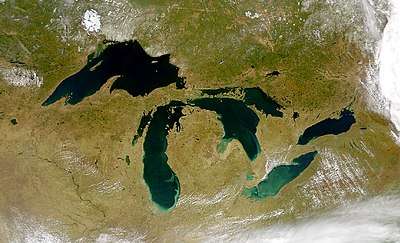 | |
| Secondary lakes | ||
| Bays and Waterways |
| |
| Islands | ||
| Historic geology | ||
| Government |
| |
| Related topics | ||
| Authority control |
|
|---|