Urban agglomeration of Montreal
Montréal is one of the administrative regions of the Canadian province of Quebec. It is also a territory equivalent to a regional county municipality (TE) and a census division (CD), for both of which its geographical code is 66. Prior to the merger of the municipalities in Region 06 in 2002, the administrative region was co-extensive with the Montreal Urban Community.
Montreal Montréal | |
|---|---|
 | |
| Coordinates: 45°30′N 73°34′W | |
| Country | |
| Province | |
| Government | |
| • Regional conference of elected officers | Manon Barbe (President) |
| Area | |
| • Land | 499.26 km2 (192.77 sq mi) |
| Population (2016)[1] | |
| • Total | 1,942,044 |
| • Density | 3,889.8/km2 (10,075/sq mi) |
| Demonym(s) | Montréalais(e)/Montrealer |
| Time zone | UTC-5 (EST) |
| • Summer (DST) | UTC-4 (EDT) |
| Postal code | H |
| Area code | 514 and 438 |
| Website | montreal.gouv.qc.ca |
| [2] | |
Located in the southern part of the province, the territory includes several of the islands of the Hochelaga Archipelago in the Saint Lawrence River, including the Island of Montreal, Nuns' Island (Île des Sœurs), Île Bizard, Saint Helen's Island (Île Sainte-Hélène), Île Notre-Dame, Dorval Island (Île Dorval), and several others.
The region is the second-smallest in area (499.26 km², or 192.77 sq mi) and most populous (1,942,044 as of the 2016 Canadian Census)[1] of Quebec's seventeen administrative regions.
Montreal Agglomeration Council
It consists of the 2002–2005 territory of the city of Montreal, and is coextensive with the Urban Agglomeration of Montreal (French: Agglomération de Montréal). Following merger of all the municipalities of the agglomeration into one on January 1, 2002, sixteen of its municipalities were reconstituted on January 1, 2006. The urban agglomeration is governed by the Montreal Agglomeration Council (French: Conseil d'agglomération de Montréal).
The executive of the urban agglomeration is the agglomeration council. The weighting of votes for the council breaks down to 87% for the City of Montreal, and 13% for the other municipalities of the Island of Montreal.[3]
Subdivisions
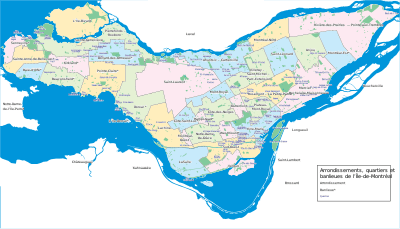
Cities
- Baie-d'Urfé
- Beaconsfield
- Côte Saint-Luc
- Dollard-des-Ormeaux
- Dorval
- Hampstead
- Kirkland
- L'Île-Dorval
- Montreal (Montréal in French)
- Borough of Ahuntsic-Cartierville
- Borough of Anjou
- Borough of Côte-des-Neiges–Notre-Dame-de-Grâce
- Borough of L'Île-Bizard–Sainte-Geneviève
- Borough of LaSalle
- Borough of Lachine
- Borough of Le Plateau-Mont-Royal
- Borough of Le Sud-Ouest
- Borough of Mercier–Hochelaga-Maisonneuve
- Borough of Montréal-Nord
- Borough of Outremont
- Borough of Pierrefonds-Roxboro
- Borough of Rivière-des-Prairies–Pointe-aux-Trembles
- Borough of Rosemont–La Petite-Patrie
- Borough of Saint-Laurent
- Borough of Saint-Léonard
- Borough of Verdun
- Borough of Ville-Marie
- Borough of Villeray–Saint-Michel–Parc-Extension
- Montréal-Est
- Montreal West (Montréal-Ouest in French)
- Mount Royal (Mont-Royal in French)
- Pointe-Claire
- Sainte-Anne-de-Bellevue
- Westmount
Village
See also
References
- "Census Profile, 2016 Census: Montréal [Economic region], Quebec". Statistics Canada. Retrieved November 22, 2019.
- "La région de Montréal, ainsi que ses MRC et TE". Profils des régions et des MRC (in French). Quebec: Institut de la statistique du Québec. 2011. Retrieved 11 September 2012.
- The Gazette (Montreal), "Tremblay eats crow at council", Linda Gyulal, 4 December 2009 (accessed 12/01/10)
External links
- Portail régional de Montréal (archived website)
- From the official website of the City of Montréal
- French website
- English website
- beta website, in English
- Montréal region Statistics Canada
| Municipalities |
|
|---|---|
| Subdivisions | |
|---|---|
| Communities | |
| Major cities | |
| Regions | |
Portal:Canada | |