Saint-Jean-sur-Richelieu
Saint-Jean-sur-Richelieu (French pronunciation: [sɛ̃ ʒɑ̃ syʁ ʁiʃ(ə)ljø]) is a city in eastern Montérégie in the Canadian province of Quebec, about 40 kilometres (25 mi) southeast of Montreal. It is situated on the west bank of the Richelieu River at the northernmost navigable point of Lake Champlain. As of 2016 the population of Saint-Jean-sur-Richelieu was 95,114.
Saint-Jean-sur-Richelieu | |
|---|---|
City | |
| Ville de Saint-Jean-sur-Richelieu | |
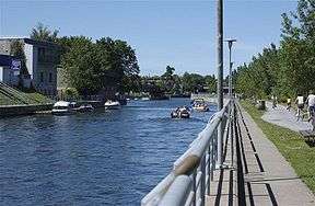
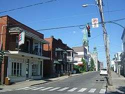 Downtown Saint Jean sur Richelieu | |
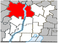 Location within Le Haut-Richelieu RCM | |
 St-Jean-sur-Richelieu Location within Quebec | |
| Coordinates: 45°19′N 73°16′W[1] | |
| Country | Canada |
| Province | Quebec |
| Region | Montérégie |
| RCM | Le Haut-Richelieu |
| Settled | 1665 |
| Constituted | January 24, 2001 |
| Government | |
| • Mayor | Alain Laplante |
| • Federal riding | Saint-Jean |
| • Prov. riding | Iberville and Saint-Jean |
| Area | |
| • Land | 226.63 km2 (87.50 sq mi) |
| • Urban | 51.78 km2 (19.99 sq mi) |
| Population (2016)[4] | |
| • City | 92,394 |
| • Density | 419.7/km2 (1,087/sq mi) |
| • Urban | 84,685 |
| • Urban density | 1,635.5/km2 (4,236/sq mi) |
| • | |
| • Dwellings | 42,036 |
| Time zone | UTC−5 (EST) |
| • Summer (DST) | UTC−4 (EDT) |
| Postal code(s) | J0J1R0, J2W, J2X, J2Y, J3A, J3B |
| Area code(s) | 450 and 579 |
| Highways | |
| Website | www.ville.saint-jean -sur-richelieu.qc.ca |
History
Historically, the city has been an important transportation hub. The first railway line in British North America connected it with La Prairie in 1836. It also hosts the annual International Balloon Festival of Saint-Jean-sur-Richelieu, a hot air balloon festival which attracts thousands of tourists who come to see the hundreds of balloons in the sky each August.
The Chambly Canal extends 20 kilometres (12 mi) north along the west bank of the river and provides modern freight passage to Chambly and the St. Lawrence River. The canal has one lock near the downtown core of Saint-Jean-sur-Richelieu. In the winter, the city builds a skating rink on the canal near the lock. In the summer, the embankment on the east side of the canal has a 20-kilometre (12 mi) cycling path.
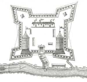
The French built Fort Saint-Jean (Quebec) in the seventeenth century. Known to early English settlers as St. Johns, it provided an important communication link during the French and Indian Wars. During the American Revolutionary War control of the town changed hands several times as British and American forces moved through the area.
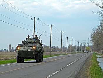
Today St-Jean is a manufacturing centre for textiles, food and wood products. It hosts an Area Support Unit (ASU) of the Canadian Forces, which functions as a primary recruit and officer training establishment.
In 2001 the city and several adjoining communities were merged into the new regional county municipality with a population to 79,600. This merger was requested by the five municipalities involved and was not part of the municipal fusions imposed by the Quebec government the following year.
Geography
Saint-Jean-sur-Richelieu is located on the banks of the Richelieu River. The city is the seat of Le Haut-Richelieu regional county municipality and of the judicial district of Iberville.[6]
Demographics
Population
| Canada census – Saint-Jean-sur-Richelieu community profile | |||
|---|---|---|---|
| 2011 | 2006 | ||
| Population: | 92,394 (+5.6% from 2006) | 87,492 (+9.9% from 2001) | |
| Land area: | 225.78 km2 (87.17 sq mi) | 225.78 km2 (87.17 sq mi) | |
| Population density: | 409.2/km2 (1,060/sq mi) | 387.5/km2 (1,004/sq mi) | |
| Median age: | 41.1 (M: 39.8, F: 42.3) | 40.2 (M: 39.2, F: 41.3) | |
| Total private dwellings: | 40,411 | 37,774 | |
| Median household income: | $55,412 | $48,609 | |
| Notes: Includes adjustment for 2001 merger with Saint-Luc, Iberville, Saint-Athanase and L'Acadie. – References: 2011[7] 2006[8] earlier[9] | |||
| Historical Census Data - Saint-Jean-sur-Richelieu, Quebec[10] | |||||||||||||||||||||||||||||
|---|---|---|---|---|---|---|---|---|---|---|---|---|---|---|---|---|---|---|---|---|---|---|---|---|---|---|---|---|---|
|
|
| |||||||||||||||||||||||||||
(M) adjustment due to the merger with Saint-Luc, Iberville, Saint-Athanase and L'Acadie. | |||||||||||||||||||||||||||||
The amalgamated municipalities (with 2001 population) were:
- Saint-Jean-sur-Richelieu (37,386)
- Saint-Luc (20,573)
- Iberville (9,424)
- Saint-Athanase (6,691)
- L'Acadie (5,526)
Despite the fact that nearby Montreal is very racially diverse, Saint-Jean-sur-Richelieu has a very large majority of white residents (93.3%). 2.4% of residents are visible minorities and 4.3% are aboriginal.[11]
Language
| Canada Census Mother Tongue - Saint-Jean-sur-Richelieu, Quebec[10] | ||||||||||||||||||
|---|---|---|---|---|---|---|---|---|---|---|---|---|---|---|---|---|---|---|
| Census | Total | French |
English |
French & English |
Other | |||||||||||||
| Year | Responses | Count | Trend | Pop % | Count | Trend | Pop % | Count | Trend | Pop % | Count | Trend | Pop % | |||||
2016 |
95,114 |
88,535 | 93.08% | 2,315 | 2.43% | 810 | 0.85% | 1,980 | 2.08% | |||||||||
2011 |
91,400 |
86,635 | 94.79% | 2,415 | 2.64% | 755 | 0.83% | 1,595 | 1.74% | |||||||||
2006 |
86,075 |
81,445 | 94.62% | 2,110 | 2.45% | 510 | 0.59% | 2,010 | 2.34% | |||||||||
2001 |
36,745 |
34,350 | 93.48% | 1,255 | 3.42% | 270 | 0.73% | 870 | 2.37% | |||||||||
1996 |
35,825 |
33,985 | n/a | 94.86% | 1,080 | n/a | 3.01% | 260 | n/a | 0.73% | 500 | n/a | 1.40% | |||||
Neighbourhoods
The city is divided in five sectors which refer to the former municipalities. Each sector contains different neighbourhoods:
| Saint-Jean | Saint-Luc | Iberville | Saint-Athanase | Acadie |
|---|---|---|---|---|
| Vieux-Saint-Jean | Saint-Luc ("le Village") | Vieux-Iberville | Les Mille-Roches | Vieux-L'Acadie (Village) |
| Saint-Gérard | Les Prés-Verts | Saint-Athanase | Saint-Athanase-Sud | Domaine-Deland |
| Saint-Edmond | Talon | Saint-Noël-Chabanel | La Canadienne | |
| Saint-Lucien | L'Île-Sainte-Thérèse | Sacré-Coeur | Ruisseau-des-Noyers | |
| Saint-Eugène | ||||
| Notre-Dame-Auxiliatrice | ||||
| Notre-Dame-de-Lourdes | ||||
| Normandie |
Economy
Saint-Jean-sur-Richelieu is home to the Carrefour Richelieu regional shopping mall which has 115 stores.[12]
Commuting patterns
The Ville de Saint-Jean-sur-Richelieu public transit system provides commuter and local bus services.
According to the 2016 Census, 22,840 residents, or 56.7% of the labour force work within the city. An additional 5,135 (12.7%) commute to Montreal, while 2,305 (5.7%) work in Longueuil, 1,440 (3.6%) work in Brossard, and 965 (2.4%) work in Chambly.
By contrast only 770 people commute from Montreal to work in Saint-Jean-sur-Richelieu every day, while 795 people commute from Longueuil, 780 commute from Chambly, 510 commute from Saint-Alexandre and 500 commute from Mont-Saint-Grégoire.[13]
Transportation
The city is split in two by Autoroute de la Vallée-des-Forts (Autoroute 35) which goes North-South by going first through Saint-Luc district, then turns east just south of Pierre-Caisse Boulevard in Saint-Jean-sur-Richlieu district to cross the Richelieu River and to finally continue its way south through St-Athanase and Iberville districts. The highway continues south for some 24 km before ending at Saint-Sébastien.
Saint-Jean-sur-Richelieu has its own municipal airport, Saint-Jean Airport, and is also close to Montreal Pierre-Elliot Trudeau International Airport.
The former International Railway of Maine runs through the town, now the connecting point for the Central Maine and Quebec Railway with the Canadian Pacific Railway. The former Saint-Jean-d'Iberville railway station is now a preserved building.
Education
The South Shore Protestant Regional School Board previously served the municipality.[14]
Royal Military College Saint-Jean (French: Collège militaire royal de Saint-Jean) serves as a one-year preparatory program for the Royal Military College of Canada in Kingston, Ontario. Original founded in 1952, it ceased being a degree granting military college in 1995 due to cuts to military funding. RMCSJ continued to provide non-degree college programs for French-speaking cadets of the Canadian Forces. The Canadian federal government reopened the military college at Saint-Jean-sur-Richelieu in the fall of 2007 to provide the full first year of university, equivalent to the Kingston program, for students with English- or French-language backgrounds alongside the college program.
Notable natives and residents
- Art Alexandre, professional ice hockey player, left wing for the Montreal Canadiens (NHL)
- Edward Antill, American lieutenant colonel who participated in the 1775 Battle of Quebec and married a Quebecer, died here
- Les Appendices, comedy group
- Diane Boudreau, writer
- Alexandre Boulerice, communication, adviser, community activist, journalist
- Gerry Boulet, rock singer for the Offenbach band
- Isabelle Brasseur, 1993 World Figure Skating Champion (Pairs), 1992/1994 Olympic bronze medalist
- Éric Bruneau, actor
- David Cadieux, Canadian champion heavyweight boxer
- Capitaine Révolte, music group formed in Saint-Jean-sur-Richelieu in 1998
- David Choinière, footballer for the Canadian Premier League side Forge FC
- Stéphane Crête, actor
- Jeff Deslauriers, professional ice hockey goaltender, former Anaheim Ducks (NHL)
- Denis Gauthier, former professional ice hockey defenceman who played for the Calgary Flames, Phoenix Coyotes, Philadelphia Flyers and Los Angeles Kings (NHL)
- Marc Gélinas, baseball profesional, former Pittsburgh Pirates pitching prospect (MLB) and Executive Director of McGill Athletics and Recreation
- Bernard "Boom Boom" Geoffrion, right wing hockey player, former Montreal Canadien (NHL), considered as one of the innovators of the slapshot
- Claude Giroux, wrestler
- Hélène Harbec, Canadian journalist and poet
- Israël Landry, teacher, musician, music merchant, editor in chief, consul
- Rina Lasnier, GOQ, Canadian poet
- Pierre Légaré, stand-up comic
- Jean Lemieux, physician, novel and short-story writer
- Antoine L'Estage, Canada's most successful rally driver, 10-time Canadian Rally Championship winner, North American Rally Cup winner and Rally X-Games participant
- Didier Lucien, Quebec actor of Haitian origin
- Félix-Gabriel Marchand, journalist, author, notary and 11th Premier of Quebec (1897–1900)
- Joséphine Marchand-Dandurand, journalist, writer, and feminist activist
- Claudine Mercier, comedian, singer, actress and impressionist
- Jean-François Mercier, comedian, screenwriter and television host
- Kevin Owens, wrestler
- Jean-Marc Parent, comedian
- Danny Plourde, poet, novelist and professor
- Jean-Francois Quintin, hockey player, left wing for the San Jose Sharks (NHL)
- Claude Raymond (baseball) was a major league pitcher and later a sports commentator.
- Nathalie Richard, Quebec rally copilot
- Alain Rochat, Swiss footballer
- Joey Scarpellino, actor
- Local ska/punk/reggae band Subb was formed in Saint-Jean-sur-Richelieu in 1992. They are major contributors to the ska-punk scene in Quebec and the rest of Canada.
- Valérie Tétreault, tennis player
- Pierre Tougas, watercolor painter
- Marie Turgeon, actress
- The Villeneuve family, racing drivers:
- Gilles Villeneuve, Canadian racing driver, brother of Jacques-Joseph Villeneuve (born in Berthierville) and father of Jacques Villeneuve
- Jacques Villeneuve, 1995 CART Champion, 1995 Indianapolis 500 Champion, and 1997 Formula One World Champion, NASCAR driver
- Mike Ward, comedian
See also
- Le Haut-Richelieu Regional County Municipality
- Sainte-Thérèse Island
- Rivière des Iroquois
- Chambly Canal
- Richelieu River
- Champlain and St. Lawrence Railroad
- Royal Military College Saint-Jean
- L'Acadie (ancienne municipalité ayant fusionnée avec Saint-Jean-sur-Richelieu en 2001.
- List of cities in Quebec
References
- Reference number 92441 of the Commission de toponymie du Québec (in French)
- Ministère des Affaires municipales, des Régions et de l'Occupation du territoire: Saint-Jean-sur-Richelieu
- Parliament of Canada Federal Riding History: SAINT-JEAN (Quebec)
- , 2016 Census Municipal Data.
- , 2016 Census Population Centre.
- Territorial Division Act. Revised Statutes of Quebec D-11.
- "2011 Community Profiles". 2011 Canadian Census. Statistics Canada. July 5, 2013. Retrieved 2014-03-09.
- "2006 Community Profiles". 2006 Canadian Census. Statistics Canada. March 30, 2011. Retrieved 2014-03-09.
- "2001 Community Profiles". 2001 Canadian Census. Statistics Canada. February 17, 2012.
- Statistics Canada: 1996, 2001, 2006, 2011, 2016census
- Government of Canada, Statistics Canada (2017-02-08). "Census Profile, 2016 Census - Saint-Jean-sur-Richelieu, Ville [Census subdivision], Quebec and Le Haut-Richelieu, Municipalité régionale de comté [Census division], Quebec". www12.statcan.gc.ca. Retrieved 2019-08-08.
- "Carrefour Richelieu". The Westcliff Group of Companies. 2007. Archived from the original on 23 October 2011. Retrieved 28 December 2011.
- "2016 Census".
- King, M.J. (Chairperson of the board). "South Shore Protestant Regional School Board" (St. Johns, PQ). The News and Eastern Townships Advocate. Volume 119, No. 5. Thursday December 16, 1965. p. 2. Retrieved from Google News on November 23, 2014.
External links
| Wikimedia Commons has media related to Saint-Jean-sur-Richelieu. |
- Official website - www.ville.saint-jean-sur-richelieu.qc.ca
- Saint-Jean-sur-Richelieu Tourism
- International de Montgolfières de Saint-Jean-sur-Richelieu
Adjacent Municipal Subdivisions | ||||||||||
|---|---|---|---|---|---|---|---|---|---|---|
| ||||||||||
| Cities & Towns | |
|---|---|
| Municipalities | |
| Parishes | |
| |
| Authority control |
|
|---|