Umm Safa
Umm Safa/Kafr Ishwa (Arabic: أم صفا) is a Palestinian village in the Ramallah and al-Bireh Governorate.
Umm Safa | |
|---|---|
| Arabic transcription(s) | |
| • Arabic | أم صفا |
| • Latin | Kafr Ishwa (unofficial) |
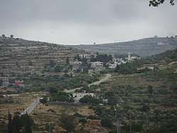 Umm Safa from the west | |
 Umm Safa Location of Umm Safa within Palestine | |
| Coordinates: 32°00′30″N 35°09′50″E | |
| Palestine grid | 165/157 |
| State | State of Palestine |
| Governorate | Ramallah and al-Bireh |
| Government | |
| • Type | Village council |
| Elevation | 647 m (2,123 ft) |
| Name meaning | "the mother of flat ground"[2] |
Location
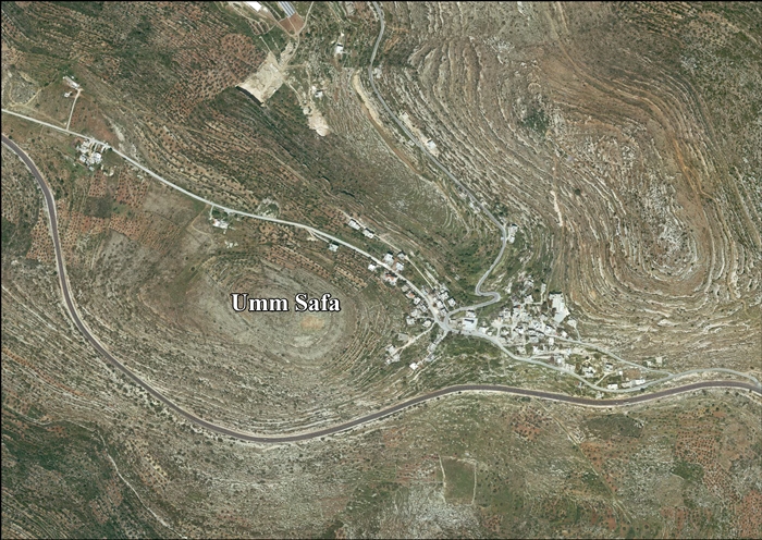
Umm Safa is located 12.1 kilometers (7.5 mi) north of Ramallah. It is bordered by 'Ajjul and 'Atara to the east, Deir as Sudan and Ajjul to the north, An Nabi Salih and Deir Nidham to the west, and Jibiya, Burham and Kobar to the south.[1]
History
It has been suggested that this was "apparently connected with an ancient Ishvah or Mizpeh,"[3][4] but this does not agree with modern archaeology.[5]
Ceramic remains from the Byzantine era have been found here,[6] as have sherds from the Crusader/Ayyubid and Mamluk eras.[5]
Ottoman era
Pottery sherds from the early Ottoman era have also been found here,[5] and it was mentioned in the sixteenth hundreds tax records under the name of Kafr Shu.[7]
In 1838 Um Safah was noted as a Muslim village the Beni Zaid district.[8]
In 1870, Victor Guérin climbed up on the hilltop which Umm Safa occupied, and found that the village had about 300 inhabitants. He further noted that: "It must go back to an ancient site as is shown by the materials used in the building of some houses and several columnar sections scattered about the ground. A copious spring, called Ain Umm Safa, provides the villagers with water. They venerate, under a koubbeh, the remains of Nabi Hanan."[9] An official Ottoman village list from about the same year, 1870, listed Kefr Eschwa as having 24 houses and a population of 120, though the population count included men, only. It was noted as being located north of Dschibija.[10][11]
In 1882 the PEF's Survey of Western Palestine (SWP) described Umm Suffah (also called Kefr Ishwah) as "a village on high ground on the Roman road to Antipatris. It contains a small mosque or Moslem chapel, and has a well to the north."[3]
British Mandate era
In the 1922 census of Palestine, conducted by the British Mandate authorities, Umm Sufa had a population of 80 Muslims,[12] increasing in the 1931 census to 89 Muslims, in 27 houses in Umm Safah (or Kafr Ishwa).[13]
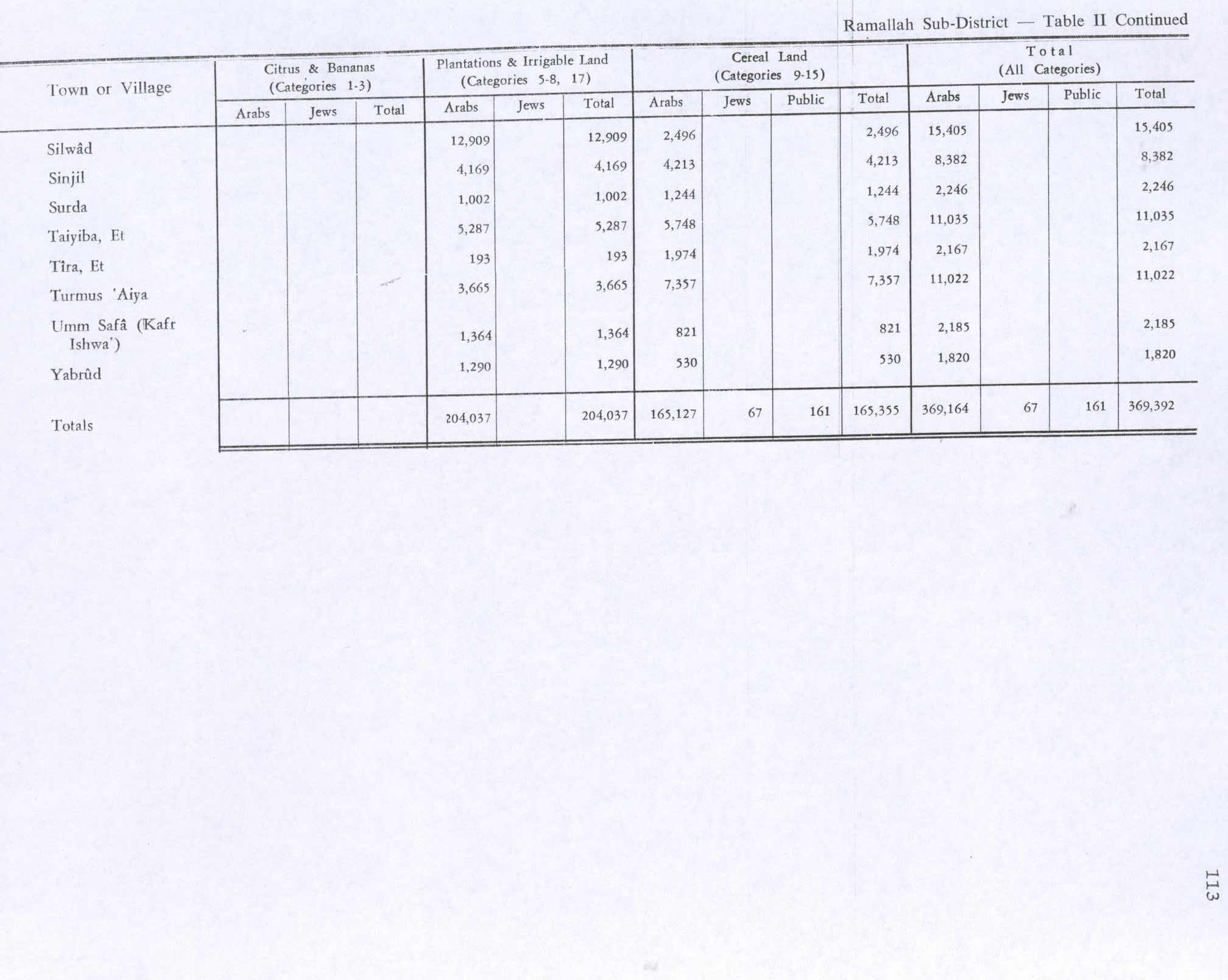
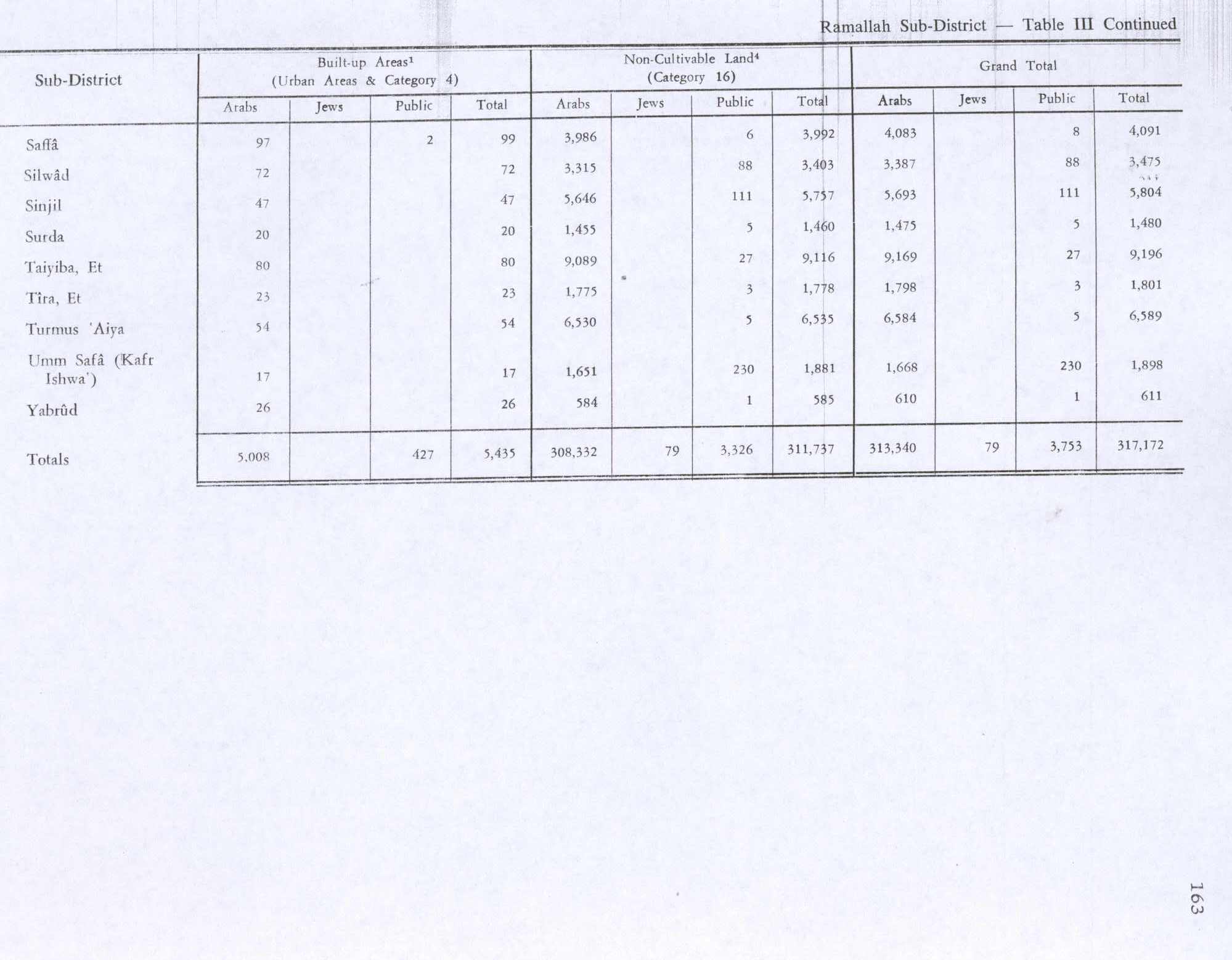
In the 1945 statistics, the population of Umm Safa (Kafr Ishwa) was 110 Muslims,[14] while the total land area was 4,083 dunams, according to an official land and population survey.[15] Of this, 1,364 dunums were used for plantations and irrigable land, 821 for cereals,[16] while 17 dunams were classified as built-up areas.[17]
Jordanian era
In the wake of the 1948 Arab–Israeli War, and after the 1949 Armistice Agreements, Umm Safa came under Jordanian rule.
The Jordanian census of 1961 found 252 inhabitants in Umm Safa.[18]
1967-present
Since the Six-Day War in 1967, Umm Safa has been under Israeli occupation.
After the 1995 accords, 16% of village land has been defined as Area B land, while the remaining 84% is Area C. Israel has confiscated a total of 227 dunams of land from the village in order to construct two Israeli settlements: Ateret and Hallamish.[19]
References
- Umm Safa Village Profile, ARIJ, p. 4
- Palmer, 1881, p. 246
- Conder and Kitchener, 1882, SWP II, p. 291
- Conder and Kitchener, 1883, SWP II, p. 378
- Finkelstein et al, 1997, p. 401
- Dauphin, 1998, p. 826
- Toledano, 1984, p. 295, has it at location 35°09′30″E 32°00′30″N
- Robinson and Smith, 1841, vol. 3, 2nd Appendix, p. 125
- Guérin, 1875, p. 109
- Socin, 1879, p. 156 It was also noted as part of the Beni Zeid district
- Hartmann, 1883, p. 106 also noted 24 houses
- Barron, 1923, Table VII, Sub-district of Ramallah, p. 17
- Mills, 1932, p. 51.
- Government of Palestine, Department of Statistics, 1945, p. 26
- Government of Palestine, Department of Statistics. Village Statistics, April, 1945. Quoted in Hadawi, 1970, p. 65
- Government of Palestine, Department of Statistics. Village Statistics, April, 1945. Quoted in Hadawi, 1970, p. 113
- Government of Palestine, Department of Statistics. Village Statistics, April, 1945. Quoted in Hadawi, 1970, p. 163
- Government of Jordan, Department of Statistics, 1964, p. 24
- Umm Safa Village Profile, ARIJ, p. 16
- Frantzman and Bar, 2013, p. 102
Bibliography
- Barron, J.B., ed. (1923). Palestine: Report and General Abstracts of the Census of 1922. Government of Palestine.
- Dauphin, Claudine (1998). La Palestine byzantine, Peuplement et Populations. BAR International Series 726 (in French). III : Catalogue. Oxford: Archeopress. ISBN 0-860549-05-4.
- Conder, C.R.; Kitchener, H.H. (1882). The Survey of Western Palestine: Memoirs of the Topography, Orography, Hydrography, and Archaeology. 2. London: Committee of the Palestine Exploration Fund.
- Finkelstein, I.; Lederman, Zvi, eds. (1997). Highlands of many cultures. Tel Aviv: Institute of Archaeology of Tel Aviv University Publications Section. ISBN 965-440-007-3.
- Frantzman, Seth J. and Doron Bar (2013). "Mapping Muslim Sacred Tombs in Palestine During the Mandate Period". Levant. 45 (1): 96–111.
Zibda, Umm Safa and Sinjil in the northern central highlands had two [tombs] each
- Government of Jordan, Department of Statistics (1964). First Census of Population and Housing. Volume I: Final Tables; General Characteristics of the Population (PDF).
- Government of Palestine, Department of Statistics (1945). Village Statistics, April, 1945.
- Guérin, V. (1869). Description Géographique Historique et Archéologique de la Palestine (in French). 1: Judee, pt. 3. Paris: L'Imprimerie Nationale. (Kefr Achoua (p. 39) ..mentioned in Socin)
- Guérin, V. (1875). Description Géographique Historique et Archéologique de la Palestine (in French). 2: Samarie, pt. 2. Paris: L'Imprimerie Nationale.
- Hartmann, M. (1883). "Die Ortschaftenliste des Liwa Jerusalem in dem türkischen Staatskalender für Syrien auf das Jahr 1288 der Flucht (1871)". Zeitschrift des Deutschen Palästina-Vereins. 6: 102–149.
- Hadawi, S. (1970). Village Statistics of 1945: A Classification of Land and Area ownership in Palestine. Palestine Liberation Organization Research Center.
- Mills, E., ed. (1932). Census of Palestine 1931. Population of Villages, Towns and Administrative Areas. Jerusalem: Government of Palestine.
- Palmer, E.H. (1881). The Survey of Western Palestine: Arabic and English Name Lists Collected During the Survey by Lieutenants Conder and Kitchener, R. E. Transliterated and Explained by E.H. Palmer. Committee of the Palestine Exploration Fund.
- Robinson, E.; Smith, E. (1841). Biblical Researches in Palestine, Mount Sinai and Arabia Petraea: A Journal of Travels in the year 1838. 3. Boston: Crocker & Brewster.
- Socin, A. (1879). "Alphabetisches Verzeichniss von Ortschaften des Paschalik Jerusalem". Zeitschrift des Deutschen Palästina-Vereins. 2: 135–163.
- Toledano, E. (1984). "The Sanjaq of Jerusalem in the Sixteenth Century: Aspects of Topography and Population". Archivum Ottomanicum. 9: 279–319.
External links
- Welcome To Umm Safa
- Umm Safa Welcome to Palestine
- Survey of Western Palestine, Map 14: IAA, Wikimedia commons
- Umm Safa Village (Fact Sheet), Applied Research Institute–Jerusalem (ARIJ)
- Umm Safa Village Profile, ARIJ
- Umm Safa Arial photo, ARIJ
- Locality Development Priorities and Needs in Umm Safa Village, ARIJ
| Cities |  | |
|---|---|---|
| Municipalities |
| |
| Village councils |
| |
| Refugee camps | ||