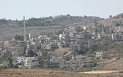
Shabtin
Shabtin is a Palestinian village in the Ramallah and al-Bireh Governorate in the central West Bank.
Shabtin | |
|---|---|
Municipality type C | |
| Arabic transcription(s) | |
| • Arabic | شبتين/شبطين |
 Shabtin | |
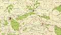
 Shabtin Location of Shabtin within Palestine | |
| Coordinates: 31°58′26″N 35°02′59″E | |
| Palestine grid | 154/153 |
| State | State of Palestine |
| Governorate | Ramallah and al-Bireh |
| Government | |
| • Type | Municipality |
| Name meaning | from personal name[1] |
Location
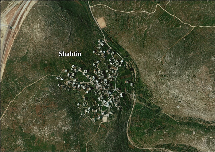
Shabtin is located 14.4 kilometres (9 mi) north-west of Ramallah. Shabtin is bordered by Al Itihad to the east, Shuqba to the north, Ni'lin to the west, and Deir Qaddis to the south.[2]
History
Just southeast of the village (at grid no. 1544/1528) is Kh. Shabtin, where pottery sherds from the Persian,[3] Persian/Hellenistic,[3] late Roman,[4] Byzantine[3][4] Umayyad/Abbasid eras have been found.[3] The SWP noted "Traces of ruins" here.[5]
Pottery sherds from the Roman/Byzantine eras have been found at Shabtin.[6]
During the Crusader era, the area was a Crusader stronghold, centred around Aboud. Remains of a house from Crusader era have been identified in the centre of Shabtin.[7]
Sherds from the Mamluk era have been found in Shabtin, together with a hoard of 45 Mamluk gold coins.[6]
Ottoman era
Sherds from the early Ottoman era has also been found here.[6]
In the 1840s, the village got caught up in the Qays–Yaman rivalry and was at one time plundered.[8]
In 1870, Victor Guérin noted the village, Cheptin, on the slopes of a hill in the distance.[9] An Ottoman village list of the same year, 1870, showed that Schetin had 16 houses and a population of 42, though the population count only included men.[10][11]
In 1882, the PEF's Survey of Western Palestine (SWP) described ‘’Shebtin’’ as: "a small village in a valley, with a well to the east. It appears to be an ancient site, and has rock cut tombs south of it."[12]
British Mandate era
In the 1922 census of Palestine, conducted by the British Mandate authorities, Shebtin had a population of 63 inhabitants, all Muslims,[13] increasing in the 1931 census to a population of 110, still all Muslim, in 20 houses.[14]
In 1945 statistics the population of Shabtin was 150 Muslims,[15] with 4,423 dunams of land, according to an official land and population survey.[16] Of this, 27 dunams were used for plantations and irrigable land, 1,158 dunams for cereals,[17] while 7 dunams were built-up (urban) land.[18]
 Shabtin 1944 1:20,000
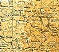 Shabtin 1945 1:250,000
Jordanian era
In the wake of the 1948 Arab–Israeli War, Shabtin came under Jordanian rule.
The Jordanian census of 1961 found 232 inhabitants.[19]
Post-1967
During the Six-Day War in 1967, Shabtin came under Israeli occupation.
After the 1995 accords, 7.2% of Shabtin land was classified as Area B, the remaining 92.8% as Area C.[20]
Israel has confiscated 1,781 dunams of land from Shabtin in order to construct two settlements, Nili and Na'aleh.[21]
References
- Palmer, 1881, p. 241
- Shabtin Village Profile, ARIJ, p. 4
- Finkelstein et al, 1997, p. 194
- Dauphin, 1998, p. 830
- Conder and Kitchener, 1882, SWP II, p. 355
- Finkelstein et al, 1997, p. 195
- Ellenblum, 2003, pp. 134, 180
- Macalister and Masterman, 1906, pp. 43-44
- Guérin, 1875, p. 81
- Socin, 1879, p.161 It was also noted to be in the Ramla district, and noted after Der Kaddis
- Hartmann, 1883, p. 140, also noted 16 houses
- Conder and Kitchener, 1882, SWP II, p. 298
- Barron, 1923, Table VII, Division Jaffa, Sub-district of Ramleh, p. 22
- Mills, 1932, p. 23
- Government of Palestine, Department of Statistics, 1945, p. 30
- Government of Palestine, Department of Statistics. Village Statistics, April, 1945. Quoted in Hadawi, 1970, p. 68
- Government of Palestine, Department of Statistics. Village Statistics, April, 1945. Quoted in Hadawi, 1970, p. 117
- Government of Palestine, Department of Statistics. Village Statistics, April, 1945. Quoted in Hadawi, 1970, p. 167
- Government of Jordan, Department of Statistics, 1964, p. 24
- Shabtin Village Profile, ARIJ, p. 15
- Shabtin Village Profile, ARIJ, p. 16
Bibliography
- Barron, J.B., ed. (1923). Palestine: Report and General Abstracts of the Census of 1922. Government of Palestine.
- Conder, C. R.; Kitchener, H.H. (1882). The Survey of Western Palestine: Memoirs of the Topography, Orography, Hydrography, and Archaeology. 2. London: Committee of the Palestine Exploration Fund.
- Dauphin, Claudine (1998). La Palestine byzantine, Peuplement et Populations. BAR International Series 726 (in French). III : Catalogue. Oxford: Archeopress. ISBN 0-860549-05-4.
- Ellenblum, Ronnie (2003). Frankish Rural Settlement in the Latin Kingdom of Jerusalem. Cambridge University Press. ISBN 9780521521871.
- Finkelstein, I.; Lederman, Zvi, eds. (1997). Highlands of many cultures. Tel Aviv: Institute of Archaeology of Tel Aviv University Publications Section. ISBN 965-440-007-3.
- Government of Jordan, Department of Statistics (1964). First Census of Population and Housing. Volume I: Final Tables; General Characteristics of the Population (PDF).
- Government of Palestine, Department of Statistics (1945). Village Statistics, April, 1945.
- Guérin, V. (1875). Description Géographique Historique et Archéologique de la Palestine (in French). 2: Samarie, pt. 2. Paris: L'Imprimerie Nationale.
- Macalister, R.A.S.; Masterman, E.W.G. (1906). "Occasional Papers on the Modern inhabitants of Palestine, part III". Quarterly statement - Palestine Exploration Fund. 38: 33–50.
- Hartmann, M. (1883). "Die Ortschaftenliste des Liwa Jerusalem in dem türkischen Staatskalender für Syrien auf das Jahr 1288 der Flucht (1871)". Zeitschrift des Deutschen Palästina-Vereins. 6: 102–149.
- Mills, E., ed. (1932). Census of Palestine 1931. Population of Villages, Towns and Administrative Areas. Jerusalem: Government of Palestine.
- Palmer, E.H. (1881). The Survey of Western Palestine: Arabic and English Name Lists Collected During the Survey by Lieutenants Conder and Kitchener, R. E. Transliterated and Explained by E.H. Palmer. Committee of the Palestine Exploration Fund.
- Socin, A. (1879). "Alphabetisches Verzeichniss von Ortschaften des Paschalik Jerusalem". Zeitschrift des Deutschen Palästina-Vereins. 2: 135–163.
External links
- Welcome To Shabtin
- Survey of Western Palestine, Map 14: IAA, Wikimedia commons
- Shabtin Village (Fact Sheet), Applied Research Institute–Jerusalem (ARIJ)
- Shabtin Village Profile, ARIJ
- Shabtin photo, ARIJ
| Cities |  | |
|---|---|---|
| Municipalities |
| |
| Village councils |
| |
| Refugee camps | ||