Taybeh
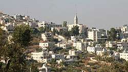
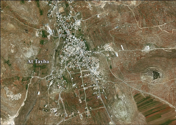
Taybeh (Arabic: الطيبة) is a Palestinian village in the West Bank, 15 kilometers (9.3 miles) northeast of Jerusalem[2] and 12 kilometers (7.4 miles) northeast of Ramallah in the Ramallah and al-Bireh Governorate, 850 meters (2788 feet) above sea level. According to the Palestinian Central Bureau of Statistics, Taybeh had a population of 1,452 in 2007.[3] According to Time magazine in 2009, it is the last all-Christian community in the West Bank.[4]
Taybeh | |
|---|---|
Place | |
| Arabic transcription(s) | |
| • Arabic | الطيبه, إفرايم |
 | |
 Taybeh Location of Taybeh 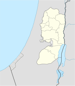 Taybeh Taybeh (the West Bank) | |
| Coordinates: 31°57′16″N 35°18′01″E | |
| Palestine grid | 178/151 |
| State | |
| Governorate | Ramallah and al-Bireh |
| Elevation | 900 m (3,000 ft) |
| Population (2010) | |
| • Total | 1,452 |
| Name meaning | "The goodly"[1] |
| Website | taybeh.weebly.com |
Etymology
The name "Taybeh" means "The goodly".[1]
According to local tradition, Saladin met a delegation of Aphram inhabitants during his wars against Crusaders. Impressed by the hospitality of the locals, he named the village Taybeh, or "goodly" in Arabic.[5] Another version of the story is that he was charmed by their goodness and the beauty of their faces, ordering the village to be renamed Tayyibat al-Isem ("beautiful of name") instead of what sounded like Afra ("full of dust").[6]
Biblical significance
Ophrah of the Old Testament
Taybeh has been identified as the site of Ophrah, mentioned in the Book of Joshua of the Hebrew Bible (Joshua 18:23) as a town of Benjamin, which was later renamed Ephraim.[7]
Aphram of the New Testament
According to the Bible, Jesus, after Lazarus' resurrection, retired with his disciples to this town. John says, "Since that day on, they (the Pharisees) made the decision to kill him. Jesus did not walk in public among the Jews anymore. He went away to a region near the desert, to a city called Aphram, and it was there that he and his disciples dwelt" (John 11: 53–54). This happened during the first days of Nissan, probably around the year 30. According to the Evangelist, Taybeh-Aphram is the isolated place where Jesus found the diaphanous quietness to prepare himself and his disciples for the great sacrifice.
The Mount of Temptation, Jebel Quruntul in Arabic, and its monastery, an important Christian pilgrimage site, is about 12 km southeast towards the Jordan as the crow flies.
History

Byzantine period
In the 5th century, a church, known today as St. George's Church, was built in the east of the town.[6]
Crusader period
In the 12th century, another church was built by the Crusaders attached to the first one.[6]
The Crusaders fortified Taybeh by means of a castle named in English the Castle of St. Elias. In February 1182, Joscelin III gave the castle to king Baldwin IV of Jerusalem along with some other properties in return for the lordship of Mi'ilya.[8][9] In 1185, the king Baldwin V of Jerusalem granted the castle to his grandfather William V, Marquess of Montferrat.[10]
However, in 1187 Taybeh fell to Saladin in the wake of the Battle of Hattin.[11] Imad ad-Din al-Isfahani (1125–1201) described it as a Crusader fortress taken by Saladin,[12] while Yaqut al-Hamawi (1179–1229) described it, under the name of 'Afra, as "a fortress in the Filastin Province, near Jerusalem."[13]
Ottoman period
In 1596, a village named Tayyibat al-Isem appeared in Ottoman tax registers as being in the Nahiya of Quds of the Liwa of Quds. It had a population of 63 Muslim households and 23 Christian families. The village paid taxes on wheat, barley, vines or fruit trees, and goats or beehives; a total of 22,100 akçe. All of the revenue went to a Waqf.[14]
Around 1810–1820 a large battle was fought in the village between rival factions of the Kais and the Yamani. Eventually the Yamani faction, led by the sheikh of Abu Ghosh, managed to regain Taybeh from the Kais faction.[15] When Edward Robinson visited in 1838, he found it to contain 75 taxable inhabitants, indicating a population of about 300–400 people.[16] It was noted as a Greek Christian village in the District of Beni Salim, east of Jerusalem.[17]
French explorer Victor Guérin visited the village in 1863, and described Thayebeh as having an estimated 800 villagers, 60 Catholics, and the rest Greek Orthodox.[18] He further noted the remains a large building on the top of a hill.[18] An Ottoman village list of about 1870 showed Taybeh to be a Christian town with 87 houses and a population of 283, though the population count included only men.[19][20]
In 1882, the Palestine Exploration Fund's Survey of Western Palestine described Taiyibeh as a "large Christian village in a conspicuous position, with well-built stone houses. A central tower stands on the top of the hill; on either side are olive and fig gardens in the low ground. The view is extensive on either side. A ruined church of St George exists near, and there are remains of a ruined castle in the village. The inhabitants are Greek Christians."[21]
Charles de Foucauld (1853–1916), an explorer and French hermit, passed through Taybeh in January 1889 and returned in 1898. Inspired by his visit, he wrote "Eight Days in Aphram, retreat of 1898, from Monday after IV Lent Sunday, (March 14) through Monday, after IV Lent Sunday (March 21)."[6]
In 1896 the population of Et-taijibe was estimated to be about 672 persons.[22]
British Mandate
In the 1922 census of Palestine conducted by the British Mandate authorities, Al Taibeh had a population of 961: 954 Christians and 7 Muslims,[23] where 663 were Orthodox, 249 Roman Catholic, 60 Greek Catholic (Melchite) and 2 were Anglican.[24]
In 1927 a Greek Orthodox church was built on a Byzantine church, carefully incorporating architectural elements, like columns, lintels, capitals, two fonts, and a fragmentary mosaic pavement with a Greek inscription.[25]
At the time of the 1931 census, Taybeh had a population of 1,125; 1,038 Christians and 87 Muslims living in 262 houses.[26]
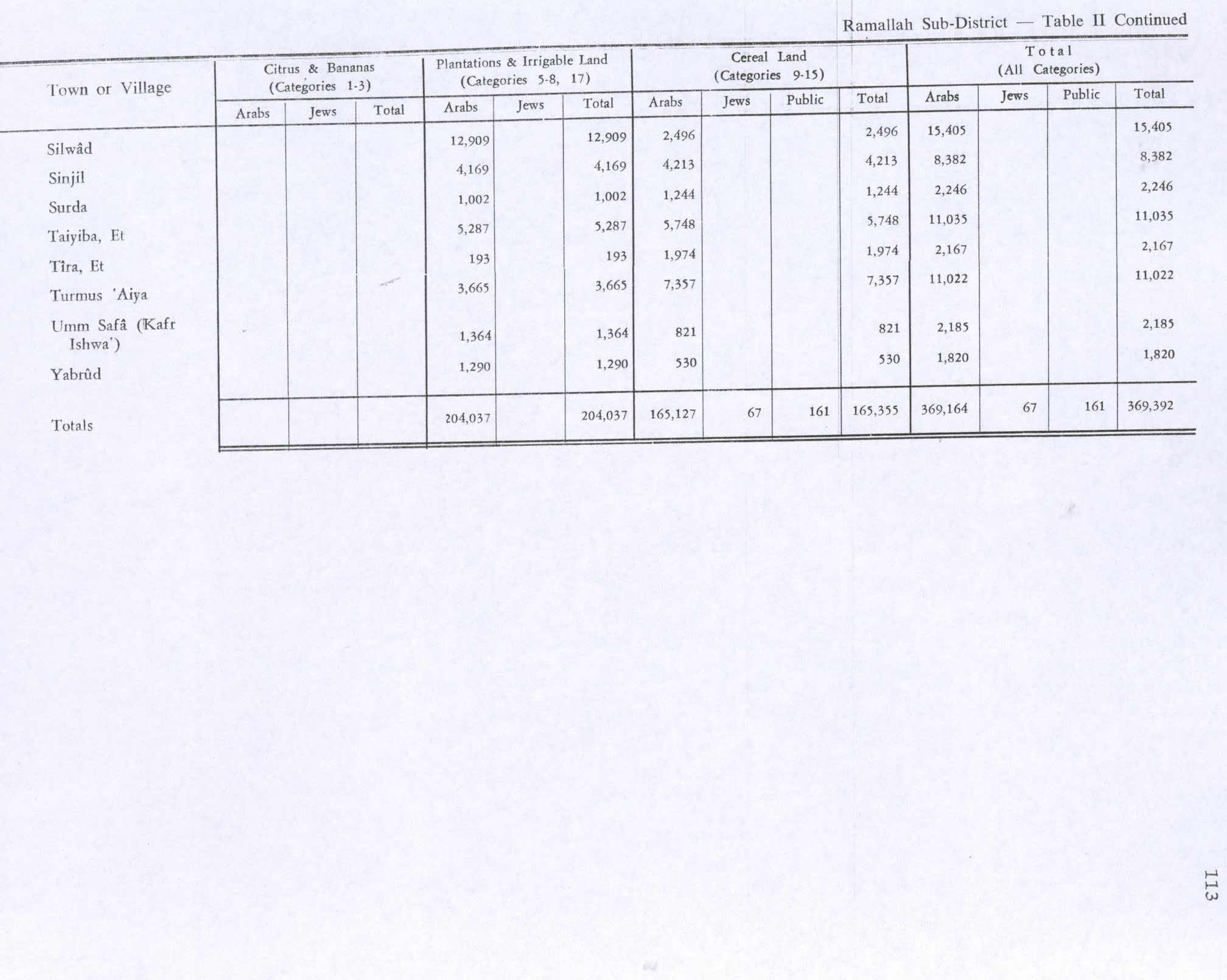
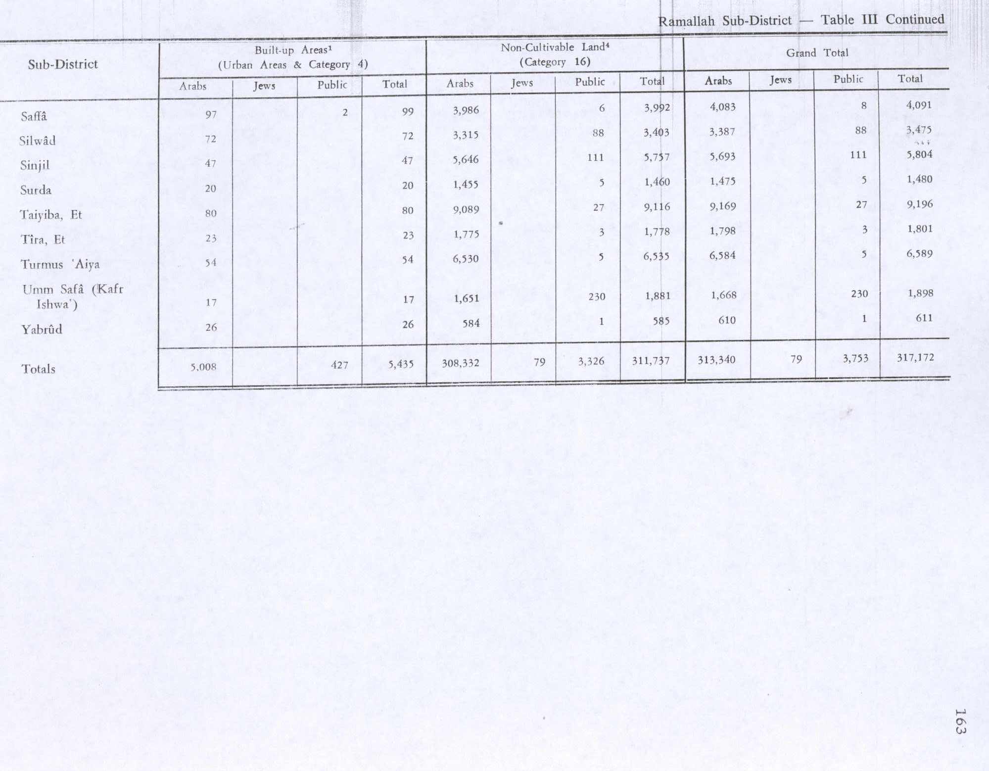
The population had increased in 1945 to 1,330; 1,180 Christians and 150 Muslims,[27] while the total land area was 20,231 dunams, according to an official land and population survey.[28] Of this 5,287 were allocated for plantations and irrigable land, 5,748 for cereals,[29] while 80 dunams were classified as built-up areas.[30]
Jordanian period
In the wake of the 1948 Arab–Israeli War, and after the 1949 Armistice Agreements, Taybeh came under Jordanian rule.
The Jordanian census of 1961 found 1,677 inhabitants in Taybeh, of whom 1,176 were Christian.[31][32]
1967 and aftermath
Since the Six-Day War in 1967, Taybeh have been under Israeli occupation.
In 1986, the Charles de Foucauld Pilgrim Center funded by the French Lieutenancy of the Knights of the Holy Sepulcher opened in the village.[33]
After the 1995 accords, 35% of village land was classified as Area B, the remaining 65% as Area C.[34] According to ARIJ, Israel has confiscated 393 dunam of land from Taybeh for the construction of the Israeli settlements of Rimmonim, and 22 dunams for Ofra.[35]
In September 2005, hundreds of Muslim men from Deir Jarir torched homes in Taybeh in response to the affair between a 30-year-old Muslim woman from Deir Jarir who was said to have been romantically involved with a Christian from Taybeh.[36] Taybeh residents called the authorities to intervene, the Israelis arrived first but they watched and did not intervene. Palestinian policemen who were coming from Ramallah were held at an Israeli checkpoint, not allowed to pass for three hours, and finally allowed to pass after constant calls from the U.S. consulate in Jerusalem.[37] Despite the incident, the neighboring towns continue to have healthy relations; residents say "the people of Taybeh and the people of Deir Jarir are one family".[36]
On 19 April 2013 Israeli settlers attempted to take over Taybeh's monastery and its adjacent chapel.[38] Youth from Taybeh and surrounding villages including Deir Jreir, Ramun, Silwad, Kafr Malik and Ein Yabrud drove out the settlers. Palestinians from the nearing zone demonstrate regularly in the monastery's land, and Muslim Palestinians hold Friday's prayers in the terrain in order to protect it from possible Israeli attempts to expropriate it.
Economy
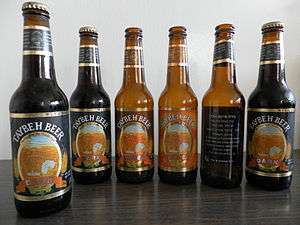
Taybeh is the home of Taybeh Brewery, one of the few breweries in Palestine.[39] Since 2005, an Oktoberfest celebration is held in Taybeh, aiming at promoting local Palestinian products and attracting tourism. The celebration offers beer competitions, cultural, traditional and musical performances and other attractions.[40] From 500 liters of beer in 1995, the company produced 600,000 liters in 2011, mainly sold in the West Bank and Israel.[2] Before the Second Intifada, the beer was sold to upscale bars in Israel. According to David Khoury, the brewery sells 6 million liters a year, and exports its products to Japan.[41]
In November 2014, Nadim Khoury, the co-founder of Taybeh Brewing Company has also opened a line of Taybeh wines marketed under the brand name "Nadim" (Arabic for "drinking companion") for a variety of wines, such as Merlot, Cabernet Sauvignon, and Syrah.[42]
Educational and religious institutions
The Orthodox Patriarchal School serves over 270 students, and the Roman Catholic (Latin) School serves over 400.[43]
The different Christian denominations worship together on Easter and Christmas. The Latin parish runs a school, a medical center, a hostel for pilgrims and youth programs.[44]
Construction of a new kindergarten and additional classrooms for Al-Taybeh Greek Orthodox School was completed in 2012 with USAID funding of $750,000. The school, built 130 years ago, is the largest in Taybeh. It is attended by 430 students from Taybeh and villages in the vicinity.[45]
Landmarks
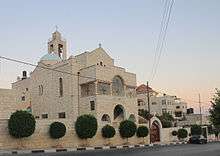
The Al-Khidr Church, or St. George Church, is located east of the centre of Taybeh, and was constructed during two periods, first in the Byzantine era, and then during the Crusader era.[46][47][48]
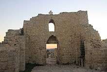
The remains of a Crusader castle, named Castle of St. Elias or Castrum Sancti Helie in Latin, can still be seen.[9][49]
Local government
The former mayor of Taybeh is David Khoury, co-owner of the local brewery established by his brother.[2]
Demographics
Taybeh is a Christian village, with Roman Catholic, Eastern Orthodox and Melkite Eastern Catholic.[50] In 2008 Taybeh had a low birthrate and residents feared that the population would entirely disappear.[51] According to the mayor, the population in 2010 was 2,300, with 12,000 former residents and their descendants living in the U.S., Chile and Guatemala.[41]
References
- Palmer, 1881, p. 245
- In search of the West Bank’s elusive Sufi Trail, Jerusalem Post
- 2007 PCBS Census. Palestinian Central Bureau of Statistics. p.114.
- Kalman, Matthew (October 8, 2009). "A Palestinian Brewery Grows in the West Bank". Time. Retrieved June 1, 2019.
- CNEWA
- Jaser, Hanna. "A village called Taybeh". United Taybeh American Association. Retrieved 30 September 2010.
- Palestinians raise a glass at West Bank Oktoberfest, Jerusalem Post
- Strehlke, 1869, pp. 13–14, no. 14; Röhricht, 1893, RRH, pp. 162–3, no. 614. Both cited in Pringle, 1998, p. 339
- Pringle, 1997, pp. 98–99
- R.H.C. Occ, ii, 1859, pp. 14–15, Ernoul (ed. de Mas Latrie), pp. 125–6, both cited in Pringle, 1998, p. 339
- Pringle, 1998, p. 339
- Finkelstein, 1997, p. 558
- Le Strange, 1890, p. 385, cited in Finkelstein, 1997, p. 588
- Hütteroth and Abdulfattah, 1977, p. 116
- Conder and Kitchener, 1882, SWP II, p. 371
- Robinson and Smith, 1841, vol 2, p. 124
- Robinson and Smith, 1841, vol 3, Appendix 2, p. 125
- Guérin, 1869, pp. 45–51; partly repeated in Guérin, 1874, pp. 206–207
- Socin, 1879, p. 161 noted that it was located in the Beni Salim District
- Hartmann, 1883, p. 115, noted 90 houses
- Conder and Kitchener, 1882, SWP II, p. 293
- Schick, 1896, p. 122
- Barron, 1923, Table VII, Sub-district of Ramallah, p. 17
- Barron, 1923, Table XIV, p. 45
- Dauphin, 1998, p. 832
- Mills, 1932, p. 51
- Government of Palestine, Department of Statistics, 1945, p. 26
- Government of Palestine, Department of Statistics. Village Statistics, April, 1945. Quoted in Hadawi, 1970, p. 65
- Government of Palestine, Department of Statistics. Village Statistics, April, 1945. Quoted in Hadawi, 1970, p. 113
- Government of Palestine, Department of Statistics. Village Statistics, April, 1945. Quoted in Hadawi, 1970, p. 163
- Government of Jordan, Department of Statistics, 1964, p. 24 It was further noted (note 2) that it was governed by a village council.
- Government of Jordan, Department of Statistics, 1964, pp. 115–116
- "The Charles de Foucauld Pilgrim Center". Taybeh's Latin parish website. Retrieved October 2, 2010.
- Et Taiyiba Town Profile (including Badiw al Mu’arrajat Locality), ARIJ, p. 20
- Et Taiyiba Town Profile (including Badiw al Mu’arrajat Locality), ARIJ, p. 21
- A frightening family feud
- "What Happened in Taybeh? (September 21, 2005)". www.saltfilms.net. Retrieved 2016-06-02.
- Settlers raise Israeli flag over West Bank church. Maan News Agency. 2013-04-19.
- Taybeh Brewing Company
- Khoury, Maria C. (18 July 2008). "Taybeh Oktoberfest Boosts Economy". Palestine News Network.
- Taybeh revisited, Haaretz
- Maria C. Khoury,Grapes of Taybeh:A Winery in the West Bank,' Counterpunch November 27, 2014.
- "Taybeh's Schools". United Taybeh American Association. Retrieved 30 September 2010.
- Palestinian Christians want a Peace Lamp in every church
- USAID funding of $750,000
- Guérin, 1869, p. 46
- Conder and Kitchener, SWP II, pp. 324–326
- Pringle, 1998, pp. 340–344
- Ellenblum, Ronnie (2007). Crusader Castles and Modern Histories. Cambridge University Press. p. 173. ISBN 9781139462556. Retrieved 7 June 2020.
- Taybeh Parish website
- Gee, Robert W. "WEST BANK GHOST TOWN / Arab Christians attempting to revive Holy Land village / Leaders work to attract more tourists, residents." Cox News Service at Houston Chronicle. Sunday December 21, 2008. Retrieved on April 22, 2009.
Bibliography
- Barron, J.B., ed. (1923). Palestine: Report and General Abstracts of the Census of 1922. Government of Palestine.
- Clermont-Ganneau, C.S. (1896). [ARP] Archaeological Researches in Palestine 1873–1874, translated from the French by J. McFarlane. 2. London: Palestine Exploration Fund. (p.280, p.293, p.295–p.298 )
- Conder, C.R.; Kitchener, H.H. (1882). The Survey of Western Palestine: Memoirs of the Topography, Orography, Hydrography, and Archaeology. 2. London: Committee of the Palestine Exploration Fund.
- Dauphin, Claudine (1998). La Palestine byzantine, Peuplement et Populations. BAR International Series 726 (in French). III : Catalogue. Oxford: Archeopress. ISBN 0-860549-05-4.
- Ellenblum, Ronnie (2003). Frankish Rural Settlement in the Latin Kingdom of Jerusalem. Cambridge University Press. ISBN 9780521521871. (pp. 120–121)
- Ernoul, B. le T.; Mas Latrie, L. (1871). Chronique d'Ernoul et de Bernard le Trésorier / publiée, pour la première ... (in French). Mme Ve J. Renouard.
- Finkelstein, I.; Lederman, Zvi, eds. (1997). Highlands of many cultures. Tel Aviv: Institute of Archaeology of Tel Aviv University Publications Section. ISBN 965-440-007-3. (II p. 587)
- Government of Jordan, Department of Statistics (1964). First Census of Population and Housing. Volume I: Final Tables; General Characteristics of the Population (PDF).
- Government of Palestine, Department of Statistics (1945). Village Statistics, April, 1945.
- Guérin, V. (1869). Description Géographique Historique et Archéologique de la Palestine (in French). 1: Judee, pt. 3. Paris: L'Imprimerie Nationale.
- Guérin, V. (1874). Description Géographique Historique et Archéologique de la Palestine (in French). 2: Samarie, pt. 1. Paris: L'Imprimerie Nationale.
- Hadawi, S. (1970). Village Statistics of 1945: A Classification of Land and Area ownership in Palestine. Palestine Liberation Organization Research Center.
- Hartmann, M. (1883). "Die Ortschaftenliste des Liwa Jerusalem in dem türkischen Staatskalender für Syrien auf das Jahr 1288 der Flucht (1871)". Zeitschrift des Deutschen Palästina-Vereins. 6: 102–149.
- Hütteroth, Wolf-Dieter; Abdulfattah, Kamal (1977). Historical Geography of Palestine, Transjordan and Southern Syria in the Late 16th Century. Erlanger Geographische Arbeiten, Sonderband 5. Erlangen, Germany: Vorstand der Fränkischen Geographischen Gesellschaft. ISBN 3-920405-41-2.
- Le Strange, G. (1890). Palestine Under the Moslems: A Description of Syria and the Holy Land from A.D. 650 to 1500. Committee of the Palestine Exploration Fund.
- Mills, E., ed. (1932). Census of Palestine 1931. Population of Villages, Towns and Administrative Areas. Jerusalem: Government of Palestine.
- McCown, C. (1921). "Muslim Shrines in Palestine". Annual of the American Schools of Oriental Research. 2–3: 47–79. (p. 66, p. 79: Pl.22)
- Palmer, E.H. (1881). The Survey of Western Palestine: Arabic and English Name Lists Collected During the Survey by Lieutenants Conder and Kitchener, R. E. Transliterated and Explained by E.H. Palmer. Committee of the Palestine Exploration Fund.
- Pringle, Denys (1997). Secular buildings in the Crusader Kingdom of Jerusalem: an archaeological Gazetter. Cambridge University Press. ISBN 0521 46010 7.
- Pringle, Denys (1998). The Churches of the Crusader Kingdom of Jerusalem: L–Z (excluding Tyre). 2. Cambridge University Press. ISBN 0 521 39037 0.
- RHC Occ: Recueil des historiens des croisades. Historiens Occidentaux (in French). 2. Paris: Imprimerie nationale. 1859.
- Robinson, E.; Smith, E. (1841). Biblical Researches in Palestine, Mount Sinai and Arabia Petraea: A Journal of Travels in the year 1838. 2. Boston: Crocker & Brewster.
- Robinson, E.; Smith, E. (1841). Biblical Researches in Palestine, Mount Sinai and Arabia Petraea: A Journal of Travels in the year 1838. 3. Boston: Crocker & Brewster.
- Röhricht, R. (1893). (RRH) Regesta regni Hierosolymitani (MXCVII–MCCXCI) (in Latin). Berlin: Libraria Academica Wageriana.
- Schick, C. (1896). "Zur Einwohnerzahl des Bezirks Jerusalem". Zeitschrift des Deutschen Palästina-Vereins. 19: 120–127.
- Socin, A. (1879). "Alphabetisches Verzeichniss von Ortschaften des Paschalik Jerusalem". Zeitschrift des Deutschen Palästina-Vereins. 2: 135–163.
- Strehlke, Ernst, ed. (1869). Tabulae Ordinis Theutonici ex tabularii regii Berolinensis codice potissimum. Berlin: Weidmanns.
External links
- Welcome To al-Tayyiba
- Taybeh, Welcome to Palestine
- Survey of Western Palestine, Map 14: IAA, Wikimedia commons
- Et Taiyiba Town (Including Badiw al Mu’arrajat Locality) (Fact Sheet), Applied Research Institute–Jerusalem (ARIJ)
- Et Taiyiba Town Profile (including Badiw al Mu’arrajat Locality), ARIJ
- Aerial photo, ARIJ
| Cities |  | |
|---|---|---|
| Municipalities |
| |
| Village councils |
| |
| Refugee camps | ||