Kafr Malik
Kafr Malik (Arabic: كفر مالك) is a Palestinian town in the Ramallah and al-Bireh Governorate, located 17 kilometers Northeast of Ramallah in the northern West Bank. According to the Palestinian Central Bureau of Statistics (PCBS), the town had a population of 2,787 inhabitants in 2007.[3]
Kafr Malik | |
|---|---|
Municipality type C | |
| Arabic transcription(s) | |
| • Arabic | كفر مالك |
| • Latin | Kofr Malik (official) |
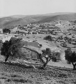 Kafr Malik, between 1900 to 1920 | |
 Kafr Malik Location of Kafr Malik within Palestine | |
| Coordinates: 31°59′23″N 35°18′32″E | |
| Palestine grid | 179/155 |
| State | State of Palestine |
| Governorate | Ramallah and al-Bireh |
| Government | |
| • Type | Municipality |
| • Head of Municipality | Majid Fahmi Abdel Majid M'adi[1] |
| Population (2007) | |
| • Total | 2,787 |
| Name meaning | The village of the landlord[2] |
Location
Kafr Malik is a Palestinian village in Ramallah Governorate, located 13.8km northeast of Ramallah. It is bordered by Al Mughayyir to the east, Al Mughayyir and Khirbet abu Falah to the north, Al Mazra'a ash Sharqiya to the west, and by Deir Jarir to the south.[4]
History
Kafr Malik has been identified with the village Caphermelic of the Crusader period.[5][6]
Ottoman era
Kafr Malik was incorporated into the Ottoman Empire in 1517 with all of Palestine, and in 1596 it appeared in the tax registers as being in the nahiya of Al-Quds in the liwa of Al-Quds. It had a population of 21 household;[7] who were all Muslims. They paid a fixed tax-rate of 33.3% on agricultural products, including wheat, barley, olive trees, vineyards, fruit trees, goats and beehives, in addition to occasional revenues; a total of 7,750 akçe.[7]
In 1838, ‘’Kefr Malik’’ was noted as a Muslim village in the District of Beni Salim, east of Jerusalem.[8]
In 1870, Victor Guérin found Kafr Malik to have 350 inhabitants, some thirty Catholics and fifteen "schismatic Greek"; the others were Muslim. In the courtyard of the medhafeh, or guesthouse, he was shown several beautiful stone plaques and three sections of columns and several capitals of the Doric form belonging to an old edifice long since destroyed.[9]
An Ottoman village list of about 1870 counted a population of 416 Muslims in 77 houses, and 15 Christians in 6 houses. In total 432 persons in 83 houses, though the population count included men only.[10][11]
In 1882, the PEF's Survey of Western Palestine described Kefr Malik as: "a village of moderate size on high ground."[12]
In 1896 the population of Kefr Malik was estimated to be about 870 persons.[13]
British Mandate era
In the 1922 census of Palestine conducted by the British Mandate authorities, the village, called Kufr Malek, had a population of 943, all Muslims,[14] increasing in the 1931 census to 972; 922 Muslims and 20 Christians, in 217 houses.[15]
In the 1945 statistics the population was 1,100; 1,080 Muslims and 20 Christians,[16] while the total land area was 52,196 dunams, according to an official land and population survey.[17] Of this, 3,580 were allocated for plantations and irrigable land, 10,984 for cereals,[18] while 53 dunams were classified as built-up (urban) areas.[19]
Jordanian era
In the wake of the 1948 Arab–Israeli War, and after the 1949 Armistice Agreements, Kafr Malik came under Jordanian rule. It was annexed by Jordan in 1950.
The Jordanian census of 1961 found 1,346 inhabitants in Kafr Malik.[20]
1967-present
Since the Six-Day War in 1967, Kafr Malik has been under Israeli occupation.
After the 1995 accords, 12,7% of Kafr Malik’s land iwas classified as Area B, the remaining 87.3% as Area C. Israel has confiscated land from Kafr Malik for the Israeli settlements of Kokhav HaShahar and Mitzpe Kramim.[21]
Footnotes
- West Bank Archived 2008-12-19 at the Wayback Machine Local Elections ( Round two)- Successful candidates by local authority, gender and No. of votes obtained, Kofr Malik p 21
- Palmer, 1881, p. 230
- 2007 PCBS Census Archived 2010-12-10 at the Wayback Machine. Palestinian Central Bureau of Statistics. p.113.
- Kafr Malik Village profile, ARIJ, p. 5
- Clermont-Ganneau, 1874, p. 162, cited in Conder and Kitchener, 1882, SWP II, p. 292
- Röhricht, 1887, p. 200, cited in Finkelstein, 1997, p. 593
- Hütteroth and Abdulfattah, 1977, p. 114
- Robinson and Smith, 1841, vol 3, Appendix 2, p. 125
- Guérin, 1874, pp. 208-209
- Socin, 1879, p. 156 also noted it was located in the Beni Salim District
- Hartmann, 1883, p. 115, also noted 83 houses
- Conder and Kitchener, 1882, SWP II, p. 292
- Schick, 1896, p. 122
- Barron, 1923, Table VII, Sub-district of Ramallah, p. 17
- Mills, 1932, p.50
- Government of Palestine, Department of Statistics, 1945, p. 26
- Government of Palestine, Department of Statistics. Village Statistics, April, 1945. Quoted in Hadawi, 1970, p. 65
- Government of Palestine, Department of Statistics. Village Statistics, April, 1945. Quoted in Hadawi, 1970, p. 112
- Government of Palestine, Department of Statistics. Village Statistics, April, 1945. Quoted in Hadawi, 1970, p. 162
- Government of Jordan, Department of Statistics, 1964, p. 24 It was further noted (note 2) that it was governed through a village council.
- Kafr Malik Village profile, ARIJ, pp. 18-20
Bibliography
- Barron, J.B., ed. (1923). Palestine: Report and General Abstracts of the Census of 1922. Government of Palestine.
- Clermont-Ganneau, C.S. (1874). "Letters from M. Clermont-Ganneau". Quarterly statement - Palestine Exploration Fund. 6: 135–178.
- Conder, C.R.; Kitchener, H.H. (1882). The Survey of Western Palestine: Memoirs of the Topography, Orography, Hydrography, and Archaeology. 2. London: Committee of the Palestine Exploration Fund.
- Finkelstein, I.; Lederman, Zvi, eds. (1997). Highlands of many cultures. Tel Aviv: Institute of Archaeology of Tel Aviv University Publications Section. ISBN 965-440-007-3.
- Government of Jordan, Department of Statistics (1964). First Census of Population and Housing. Volume I: Final Tables; General Characteristics of the Population (PDF).
- Government of Palestine, Department of Statistics (1945). Village Statistics, April, 1945.
- Guérin, V. (1874). Description Géographique Historique et Archéologique de la Palestine (in French). 2: Samarie, pt. 1. Paris: L'Imprimerie Nationale.
- Hadawi, S. (1970). Village Statistics of 1945: A Classification of Land and Area ownership in Palestine. Palestine Liberation Organization Research Center.
- Hartmann, M. (1883). "Die Ortschaftenliste des Liwa Jerusalem in dem türkischen Staatskalender für Syrien auf das Jahr 1288 der Flucht (1871)". Zeitschrift des Deutschen Palästina-Vereins. 6: 102–149.
- Hütteroth, Wolf-Dieter; Abdulfattah, Kamal (1977). Historical Geography of Palestine, Transjordan and Southern Syria in the Late 16th Century. Erlanger Geographische Arbeiten, Sonderband 5. Erlangen, Germany: Vorstand der Fränkischen Geographischen Gesellschaft. ISBN 3-920405-41-2.
- Mills, E., ed. (1932). Census of Palestine 1931. Population of Villages, Towns and Administrative Areas. Jerusalem: Government of Palestine.
- Palmer, E.H. (1881). The Survey of Western Palestine: Arabic and English Name Lists Collected During the Survey by Lieutenants Conder and Kitchener, R. E. Transliterated and Explained by E.H. Palmer. Committee of the Palestine Exploration Fund.
- Robinson, E.; Smith, E. (1841). Biblical Researches in Palestine, Mount Sinai and Arabia Petraea: A Journal of Travels in the year 1838. 3. Boston: Crocker & Brewster.
- Röhricht, R. (1887). "Studien zur mittelalterlichen Geographie und Topographie Syriens". Zeitschrift des Deutschen Palästina-Vereins. 10: 195–344.
- Schick, C. (1896). "Zur Einwohnerzahl des Bezirks Jerusalem". Zeitschrift des Deutschen Palästina-Vereins. 19: 120–127.
- Socin, A. (1879). "Alphabetisches Verzeichniss von Ortschaften des Paschalik Jerusalem". Zeitschrift des Deutschen Palästina-Vereins. 2: 135–163.
External links
- Welcome To Kafr Malik
- Survey of Western Palestine, Map 14: IAA, Wikimedia commons
- Kafr Malik Village (fact sheet), Applied Research Institute–Jerusalem (ARIJ)
- Kafr Malik Village profile, ARIJ
- Kafr Malik, aerial photo, ARIJ
- Locality Development Priorities and Needs in Kafr Malik Village, ARIJ
| Cities |  | |
|---|---|---|
| Municipalities |
| |
| Village councils |
| |
| Refugee camps | ||