Kharbatha Bani Harith
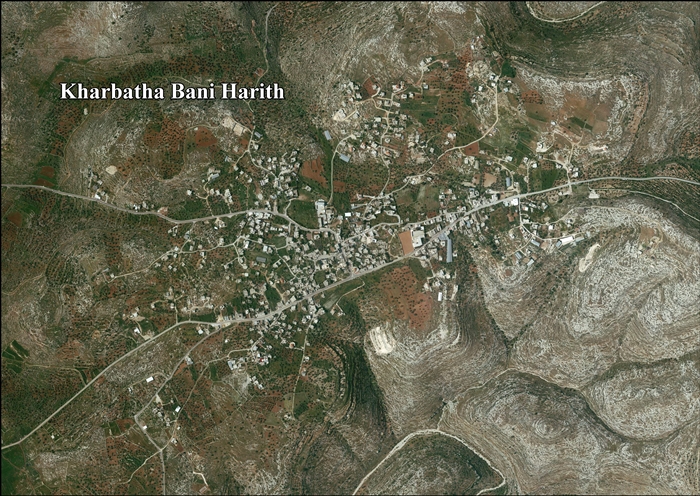
Kharbatha Bani Harith (Arabic: خربثا بني حارث) is a Palestinian town in the central West Bank, located 15 kilometers west of Ramallah in the Ramallah and al-Bireh Governorate. The name of the town is probably a corruption of Khirbat Bani Harith ("the ruins of the sons of Harith"). According to the Palestinian Central Bureau of Statistics, the town had a population of 2,846.[3] It has a total land area of 7,120 dunams.
Kharbatha Bani Harith | |
|---|---|
| Arabic transcription(s) | |
| • Arabic | خربثا بني حارث |
| • Latin | Kharbatha al-Harithiyya (official) |
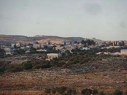 Kharbatha Bani Harith from the west | |
 Kharbatha Bani Harith Location of Kharbatha Bani Harith within Palestine | |
| Coordinates: 31°56′43″N 35°04′21″E | |
| Palestine grid | 156/150 |
| State | State of Palestine |
| Governorate | Ramallah and al-Bireh |
| Government | |
| • Type | Village council |
| Area | |
| • Total | 7,120 dunams (7.12 km2 or 2.75 sq mi) |
| Elevation | 396 m (1,299 ft) |
| Population (2007) | |
| • Total | 2,846 |
| • Density | 400/km2 (1,000/sq mi) |
| Name meaning | "The ruins of the sons of Harith"[2] |
Location
Kharbatha Bani Harith is located 13.1 kilometers (8.1 mi) west of Ramallah. It is bordered by Ras Karkar to the east, Al-Itihad to the north, Deir Qaddis to the north and west, and Bil’in and Kafr Ni’ma to the south.[1]
History
Pottery sherds from Iron Age II, Persian, Byzantine, Byzantine/Umayyad and Mamluk era have been found here.[4]
Ottoman era
Kharbatha Bani Harith was incorporated into the Ottoman Empire in 1517 with all of Palestine, and in 1596 it appeared under the name of Harabta in the tax registers, being in the nahiya ("subdistrict") of Ramla, which was under the administration of the liwa ("district") of Gaza. It had a population of 29 Muslims and 4 Christian households.[5] They paid a fixed tax-rate of 25% on agricultural products, including wheat, barley, summer crops, vineyards, fruit trees, goats and beehives, in addition to occasional revenues; a total of 2,200 Akçe. All of the revenues went to a Waqf.[6]
In 1870, Victor Guérin found the village to have about 200 inhabitants. He also noted the remains of a church,[7] which has been dated to the Byzantine era.[4]
In 1882, the PEF's Survey of Western Palestine described the village, called Khurbetha Ibn Harith, as being of medium size, with a well on the west, "standing on high ground among the olive trees."[8]
British Mandate era
In the 1922 census of Palestine, conducted by the British Mandate authorities, Kharbata had a population of 338 inhabitants, all Muslim.[9] In the 1931 census it had increased to a population of 469, still all Muslim, in 102 inhabited houses.[10]
In the 1945 statistics the population of Kharbata was 650, all Muslims,[11] who owned 7,120 dunams of land according to an official land and population survey.[12] 2,788 dunams were plantations and irrigable land, 591 used for cereals,[13] while 9 dunams were built-up (urban) land.[14]
Jordanian era
In the wake of the 1948 Arab–Israeli War, and after the 1949 Armistice Agreements, Kharbatha Bani Harith came under Jordanian rule.
The Jordanian census of 1961 found 835 inhabitants in Kh. Harithiya.[15]
1967-present
After the Six-Day War in 1967, Kharbatha Bani Harith came under Israeli occupation.
After the 1995 accords, 942 dunums of village land were classified Area B, the remaining 6,200 dunums as Area C.
According to ARIJ, 833 dunams of village land has been confiscated by Israel for the Israeli settlement of Modi'in Illit.[16][17]
See also
References
- Kharbatha Bani Harith Village Profile, ARIJ, p. 4
- Palmer, 1881, p. 237
- 2007 PCBS Census Archived 2010-12-10 at the Wayback Machine Palestinian Central Bureau of Statistics. p.114.
- Finkelstein and Lederman, 1997, p. 200
- Petersen, 2005, p. 131
- Hütteroth and Abdulfattah, 1977, p. 155
- Guérin, 1875, p. 84
- Conder and Kitchener, 1882, SWP II, p. 294
- Barron, 1923, Table VII, Sub-district of Ramleh, p. 22
- Mills, 1932, p. 21
- Government of Palestine, Department of Statistics, 1945, p. 29
- Government of Palestine, Department of Statistics. Village Statistics, April, 1945. Quoted in Hadawi, 1970, p. 67
- Government of Palestine, Department of Statistics. Village Statistics, April, 1945. Quoted in Hadawi, 1970, p. 115
- Government of Palestine, Department of Statistics. Village Statistics, April, 1945. Quoted in Hadawi, 1970, p. 165
- Government of Jordan, Department of Statistics, 1964, p. 24
- Kharbatha Bani Harith Village (Fact Sheet), ARIJ
- Kharbatha Bani Harith Village Profile, p. 4, ARIJ
Bibliography
- Barron, J.B., ed. (1923). Palestine: Report and General Abstracts of the Census of 1922. Government of Palestine.
- Conder, C.R.; Kitchener, H.H. (1882). The Survey of Western Palestine: Memoirs of the Topography, Orography, Hydrography, and Archaeology. 2. London: Committee of the Palestine Exploration Fund.
- Finkelstein, I.; Lederman, Zvi, eds. (1997). Highlands of many cultures. Tel Aviv: Institute of Archaeology of Tel Aviv University Publications Section. ISBN 965-440-007-3.
- Government of Jordan, Department of Statistics (1964). First Census of Population and Housing. Volume I: Final Tables; General Characteristics of the Population (PDF).
- Government of Palestine, Department of Statistics (1945). Village Statistics, April, 1945.
- Guérin, V. (1875). Description Géographique Historique et Archéologique de la Palestine (in French). 2: Samarie, pt. 2. Paris: L'Imprimerie Nationale.
- Hadawi, S. (1970). Village Statistics of 1945: A Classification of Land and Area ownership in Palestine. Palestine Liberation Organization Research Center.
- Hütteroth, Wolf-Dieter; Abdulfattah, Kamal (1977). Historical Geography of Palestine, Transjordan and Southern Syria in the Late 16th Century. Erlanger Geographische Arbeiten, Sonderband 5. Erlangen, Germany: Vorstand der Fränkischen Geographischen Gesellschaft. ISBN 3-920405-41-2.
- Mills, E., ed. (1932). Census of Palestine 1931. Population of Villages, Towns and Administrative Areas. Jerusalem: Government of Palestine.
- Palmer, E.H. (1881). The Survey of Western Palestine: Arabic and English Name Lists Collected During the Survey by Lieutenants Conder and Kitchener, R. E. Transliterated and Explained by E.H. Palmer. Committee of the Palestine Exploration Fund.
- Petersen, Andrew (2005). The Towns of Palestine Under Muslim Rule. British Archaeological Reports. ISBN 1841718211.
External links
- Welcome To Kharbata
- Survey of Western Palestine, Map 14: IAA, Wikimedia commons
- Kharbatha Bani Harith Village (Fact Sheet), Applied Research Institute–Jerusalem (ARIJ)
- Kharbatha Bani Harith Village Profile, ARIJ
- Kharbatha Bani Harith aerial photo, ARIJ
| Cities |  | |
|---|---|---|
| Municipalities |
| |
| Village councils |
| |
| Refugee camps | ||