Deir as-Sudan
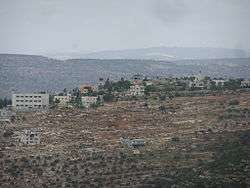
Deir as-Sudan (Arabic: دير السودان) is a Palestinian town in the Ramallah and al-Bireh Governorate, located 20 kilometers Northwest of Ramallah in the northern West Bank. According to the Palestinian Central Bureau of Statistics (PCBS), the town had a population of approximately 1,991 inhabitants in 2007.[2]
Deir as-Sudan | |
|---|---|
Municipality type C | |
| Arabic transcription(s) | |
| • Arabic | دير السودان |
 Deir as-Sudan | |
 Deir as-Sudan Location of Deir as-Sudan within Palestine | |
| Coordinates: 32°01′59″N 35°08′54″E | |
| Palestine grid | 164/160 |
| State | State of Palestine |
| Governorate | Ramallah and al-Bireh |
| Government | |
| • Type | Municipality |
| Population (2007) | |
| • Total | 1,991 |
| Name meaning | "The monastery of the negroes"[1] |
Location
Deir as Sudan is located 14.7 kilometers (9.1 mi) northwest of Ramallah. It is bordered by Ajjul to the east, Bani Zeid al-Sharqiya to the north, Kafr Ein to the west, Umm Safa and An Nabi Salih to the south.[3]
History
Ceramic sherds from the Byzantine,[4] Crusader/Ayyubid[5] and Mamluk[5] eras have been found here.
Ottoman era
In 1517, the village was included in the Ottoman empire with the rest of Palestine, and in the 1596 tax-records it appeared as Dair Sudan, located in the Nahiya of Quds of the Liwa of Al-Quds. The population was 14 households, all Muslim. They paid a fixed tax rate of 33,3% on agricultural products, such as wheat, barley, olive trees, vineyards/fruit trees, goats and beehives, in addition to occasional revenues; a total of 3,400 akçe.[6] Pottery from the early Ottoman era have also been found here.[5]
In 1838, it was noted as a Muslim village in the Beni Zeid district, north of Jerusalem.[7]
An Ottoman village list of about 1870 indicated 22 houses and a population of 90, though the population count included men, only.[8][9]
In 1882, the PEF's Survey of Western Palestine (SWP) described Deir es Sudan as: "A village of moderate size, with a well to the west, on the slope of a hill, with olive-groves round it."[10]
In 1896 the population of Der es-sudan was estimated to be about 153 persons.[11]
British Mandate era
In the 1922 census of Palestine, conducted by the British Mandate authorities, the village, named Dair Al-Sudan, had a population of 173, all Muslim,[12] increasing in the 1931 census to 243 Muslims, in 53 houses.[13]
In the 1945 statistics the population of Deir es Sudan was 280 Muslims,[14] with 4,498 dunams (4.5 km2; 1.7 sq mi) of land under their jurisdiction, according to an official land and population survey.[15] Of this, 2,416 dunams were plantations and irrigable land, 841 were for cereals,[16] while 15 dunams (1.5 ha; 3.7 acres) were built-up (urban) land.[17]
Jordanian era
In the wake of the 1948 Arab–Israeli War, and after the 1949 Armistice Agreements, Deir as-Sudan came under Jordanian rule.
The Jordanian census of 1961 found 486 inhabitants in Deir as-Sudan.[18]
1967-present
Since the Six-Day War in 1967, Deir as-Sudan has been under Israeli occupation.
After the 1995 accords, 57.2% of the village's total area has been defined as Area A land, 6.5% as Area B land, while the remaining 36.3% is Area C.[19]
References
- Palmer, 1881, p. 229
- 2007 PCBS Census Archived December 10, 2010, at the Wayback Machine. Palestinian Central Bureau of Statistics. p.112.
- Deir as Sudan village profile, ARIJ, p. 4
- Dauphin, 1998, p. 823
- Finkelstein et al, 1997, p. 455
- Hütteroth and Abdulfattah, 1977, p. 116
- Robinson and Smith, 1841, vol 3, Appendix 2, p. 124
- Socin, 1879, p. 152 It was also noted to be in the Beni Zeid district.
- Hartmann, 1883, p. 107; also noted 22 houses
- Conder and Kitchener, 1882, SWP II, p. 290
- Schick, 1896, p. 124
- Barron, 1923, Table VII, Sub-district of Ramallah, p. 16
- Mills, 1932, p. 49
- Government of Palestine, Department of Statistics, 1945, p. 26
- Government of Palestine, Department of Statistics. Village Statistics, April, 1945. Quoted in Hadawi, 1970, p. 64
- Government of Palestine, Department of Statistics. Village Statistics, April, 1945. Quoted in Hadawi, 1970, p. 112
- Government of Palestine, Department of Statistics. Village Statistics, April, 1945. Quoted in Hadawi, 1970, p. 162
- Government of Jordan, Department of Statistics, 1964, p. 24
- Deir as Sudan village profile, ARIJ, p. 16
Bibliography
- Barron, J.B., ed. (1923). Palestine: Report and General Abstracts of the Census of 1922. Government of Palestine.
- Conder, C.R.; Kitchener, H.H. (1882). The Survey of Western Palestine: Memoirs of the Topography, Orography, Hydrography, and Archaeology. 2. London: Committee of the Palestine Exploration Fund.
- Dauphin, Claudine (1998). La Palestine byzantine, Peuplement et Populations. BAR International Series 726 (in French). III : Catalogue. Oxford: Archeopress. ISBN 0-860549-05-4.
- Finkelstein, I.; Lederman, Zvi, eds. (1997). Highlands of many cultures. Tel Aviv: Institute of Archaeology of Tel Aviv University Publications Section. ISBN 965-440-007-3.
- Government of Jordan, Department of Statistics (1964). First Census of Population and Housing. Volume I: Final Tables; General Characteristics of the Population (PDF).
- Government of Palestine, Department of Statistics (1945). Village Statistics, April, 1945.
- Hadawi, S. (1970). Village Statistics of 1945: A Classification of Land and Area ownership in Palestine. Palestine Liberation Organization Research Center.
- Hartmann, M. (1883). "Die Ortschaftenliste des Liwa Jerusalem in dem türkischen Staatskalender für Syrien auf das Jahr 1288 der Flucht (1871)". Zeitschrift des Deutschen Palästina-Vereins. 6: 102–149.
- Hütteroth, Wolf-Dieter; Abdulfattah, Kamal (1977). Historical Geography of Palestine, Transjordan and Southern Syria in the Late 16th Century. Erlanger Geographische Arbeiten, Sonderband 5. Erlangen, Germany: Vorstand der Fränkischen Geographischen Gesellschaft. ISBN 3-920405-41-2.
- Mills, E., ed. (1932). Census of Palestine 1931. Population of Villages, Towns and Administrative Areas. Jerusalem: Government of Palestine.
- Palmer, E.H. (1881). The Survey of Western Palestine: Arabic and English Name Lists Collected During the Survey by Lieutenants Conder and Kitchener, R. E. Transliterated and Explained by E.H. Palmer. Committee of the Palestine Exploration Fund.
- Robinson, E.; Smith, E. (1841). Biblical Researches in Palestine, Mount Sinai and Arabia Petraea: A Journal of Travels in the year 1838. 3. Boston: Crocker & Brewster.
- Schick, C. (1896). "Zur Einwohnerzahl des Bezirks Jerusalem". Zeitschrift des Deutschen Palästina-Vereins. 19: 120–127.
- Socin, A. (1879). "Alphabetisches Verzeichniss von Ortschaften des Paschalik Jerusalem". Zeitschrift des Deutschen Palästina-Vereins. 2: 135–163.
External links
- Welcome To Dayr al-Sudan
- Deir as-Sudan, Welcome to Palestine
- Survey of Western Palestine, Map 14: IAA, Wikimedia commons
- Deir as Sudan village (fact sheet), Applied Research Institute–Jerusalem (ARIJ)
- Deir as Sudan village profile, ARIJ
- Deir as Sudan aerial photo, ARIJ
- Locality Development Priorities and Needs in Deir as Sudan Village, ARIJ
| Cities |  | |
|---|---|---|
| Municipalities |
| |
| Village councils |
| |
| Refugee camps | ||