Beit Ur al-Tahta
Beit Ur al-Tahta (Arabic: بيت عور التحتى, lit. "Lower house of straw") is a Palestinian village located in the central West Bank, in the Ramallah and Al-Bireh Governorate. The village is located on the site of the biblical Bethoron, on a hilltop facing Beit Ur al-Foqa. According to the Palestinian Central Bureau of Statistics Beit Ur at-Tahta had a population of 4,372 inhabitants in mid-2007.[3]
Beit Ur al-Tahta | |
|---|---|
Municipality type C | |
| Arabic transcription(s) | |
| • Arabic | بيت عور التحت |
| • Latin | Bayt Ur at-Tahta (unofficial) |
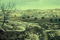 Beit Ur al-Tahta, between 1950 and 1977. | |
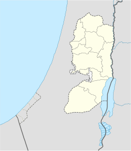 Beit Ur al-Tahta Location of Beit Ur al-Tahta within the West Bank  Beit Ur al-Tahta Location of Beit Ur al-Tahta within Palestine | |
| Coordinates: 31°53′42″N 35°05′01″E | |
| Palestine grid | 158/144 |
| State | State of Palestine |
| Governorate | Ramallah and al-Bireh |
| Government | |
| • Type | Municipality |
| Elevation | 407 m (1,335 ft) |
| Population (2007) | |
| • Total | 4,372 |
| Name meaning | "Lower house of Ur"[2] |
Location and geography
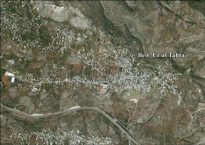
Beit 'Ur at Tahta is located 11.4 kilometers (7.1 mi) west of Ramallah. It is bordered by Beit Ur al Fauqa to the east, Deir Ibzi to the east and north, Saffa and Beit Sira to the west, and Kharbatha al Misbah to the south.[1]
The old center of Beit Ur al-Tahta is located in the southern part of the village, while the northern part is marked by wide terraces and is the site of several of the village's archaeological pieces.[4] The total area of the village is 5,653 dunams, of which 773 dunams were built-up areas.[5]
History
In January 2001, a burial cave was discovered on the southern outskirts of the village. The cave consisted of two chambers and an arched doorway. Artifacts inside the cave included several pottery fragments, a cooking pot, a bowl and goblet dating to the end of the Second Temple period (1st century BCE–1st century CE).[6]
To the west of the village is the ruins of a chapel, apparently from the Byzantine period,[7] and ceramics from the same period have also been found.[8] The place was mentioned in the 12th century as a fief of the Holy Sepulchre.[9]
Ottoman era
In 1596 the village appeared in Ottoman tax registers under the name of Bayt 'Ur as-Sufla and was part of the Nahiya ("Subdistrict") of Quds of the Liwa ("District") of Quds. It had a population of 20 Muslim households who paid a fixed tax rate of 25% on various agricultural products, including wheat, barley, olives, goats and/or beehives; a total of 3,700 akçe.[10]
In 1838 it was noted as a Muslim village, located in the Beni Malik area, west of Jerusalem.[11][12]
A 19th-century traveler visiting the town found the remains of ancient foundations, rock-cut cisterns and a tomb that was said to have contained treasures. Father P.M. Séjourné, revisiting the site, noticed the ruins of a large church: "The mosaic pavement of an important church located northeast of the village has disappeared, at least for the moment, under a watermelon field. The scattered spoils of the Christian building have enriched the neighbouring modern mosque and many hovels nearby. Fragments of a graceful frieze, capitals with Corinthian acanthus carved in white marble, columns and dressed stones lie unused along the roads." Another researcher, Victor Guérin, saw two columns from the church inside the local mosque.[13] Based on these finds, it was concluded that the village was once Christian, and had a large three-nave church.[14]
An official Ottoman village list from about 1870 showed that Bet Ur et-Tatha had 35 houses and a population of 185, though it only counted the men.[15][16]
In 1883, the PEF's Survey of Western Palestine described Beit 'Ur et Tahta as "A village of moderate size on a low ridge with wells to the west. In the middle of the village is the sacred place of Neby 'Or, with a palm tree in the courtyard: near it is a well in the street.[9]
British Mandate era
In the 1922 census of Palestine, conducted by the British Mandate authorities, Beit Ur al-Tahta had a population of 470, all Muslims,[17] while at the 1931 census, Beit 'Ur al-Tahta had 117 occupied houses and a population of 611, still all Muslim.[18]
In the 1945 statistics the population was 710, all Muslims,[19] while the total land area was 4,619 dunams, according to an official land and population survey.[20] Of this, 2,045 were allocated for plantations and irrigable land, 1,780 for cereals,[21] while 41 dunams were classified as built-up (urban) areas.[22]
 Beit Ur al-Tahta 1944 1:20,000 from 1919 survey
 Beit Ur al-Tahta 1945 1:250,000 (bottom right quadrant)
Jordanian era
In the wake of the 1948 Arab–Israeli War, and after the 1949 Armistice Agreements, Beit Ur al-Tahta came under Jordanian rule. It was annexed by Jordan in 1950.
In 1961, the population was 1,198 persons.[23]
Post 1967
Since the Six-Day War in 1967, Beit Ur al-Tahta has been under Israeli occupation. The population in the 1967 census conducted by the Israeli authorities was 920, of whom 60 originated from the Israeli territory.[24]
In the 1980s and 1990s, lands belonging to Beit Ur al-Tahta were confiscated by the Israeli government to construct Highway 443 along the pass of Bethoron. A petition challenging the move submitted to the Supreme Court of Israel in September 1983 was rejected by Justice Aharon Barak who ruled that under international law, a military government have the right to infringe private property if a number of conditions are fulfilled, stating that "The step is taken for the benefit of the local population". Highway 443 initially served as a main approach road linking the 25,000 inhabitants of six villages to each other's and to Ramallah. After the outbreak of the Second Intifada, the Israeli military prevented Palestinian use of the road and blocked some parts of it without a legal order,[25] and the construction of the Israeli West Bank barrier closed off access to the old road, which lengthened the journey.[26] In 2007, The Israeli High Court of Justice ordered the state of Israel to explain why the road has been blocked for seven years without a legal order and why Palestinians are prevented from using it.[25]
After the 1995 accords, 36.7% of village land was classified as Area B land, and the remaining 63.3% as Area C. Israel has confiscated land from the village in order to construct the Israeli settlement of Beit Horon.[27]
In October 2009, infrastructure improvements were completed in Beit Ur al-Tahta that included improved roads and street lighting. The project was funded by American Charities for Palestine, the United States Agency for International Development (USAID) and the Sheikh Mohammed Shami Foundation. The total cost was $400,000.[28]
See also
References
- Beit ‘Ur at Tahta Village Profile, ARIJ, p. 4
- Palmer, 1881, p. 287
- 2007 PCBS Census Archived December 10, 2010, at the Wayback Machine. Palestinian Central Bureau of Statistics. p.114.
- Finkelstein and Lederman, 1997, p. 161.
- Beit ‘Ur at Tahta Village Profile
- Peleg, 2004, Beit ‘Ur et-Tahta
- Conder and Kitchener, 1883, SWP III, p. 86
- Dauphin, 1998, p. 839.
- Conder and Kitchener, 1883, SWP III, p. 17
- Hütteroth and Abdulfattah, 1977, p. 117.
- Robinson and Smith, 1841, vol 3, Appendix 2, p. 124
- Robinson and Smith, 1841, vol 3, p. 59
- Guérin, 1875, p. 397
- Bethoron - (Bayt Ur)
- Socin, 1879, p. 148 It was also noted to be in the Beni Malik district
- Hartmann, 1883, p. 118 also noted 35 houses
- Barron, 1923, Table VII, Sub-district of Ramallah, p. 16
- Mills, 1932, p. 47.
- Government of Palestine, Department of Statistics, 1945, p. 26
- Government of Palestine, Department of Statistics. Village Statistics, April, 1945. Quoted in Hadawi, 1970, p. 64
- Government of Palestine, Department of Statistics. Village Statistics, April, 1945. Quoted in Hadawi, 1970, p. 111
- Government of Palestine, Department of Statistics. Village Statistics, April, 1945. Quoted in Hadawi, 1970, p. 161
- Government of Jordan, Department of Statistics, 1964, p. 24 It was further noted (note 2) that it was governed by a mukhtar.
- Perlmann, Joel (November 2011 – February 2012). "The 1967 Census of the West Bank and Gaza Strip: A Digitized Version" (PDF). Levy Economics Institute. Retrieved 23 January 2018.
- Yuval Yoaz and Akiva Elder (2007-06-08). "State told to explain Palestinian travel ban on West Bank road". Haaretz. Archived from the original on 31 August 2007. Retrieved 2007-09-12.
- Birgitta Elfström and Arne Malmgren (2005-01-31). "Palestinian Children Behind Bars" (PDF). International Commission of Jurists, Swedish Section.
- Beit ‘Ur at Tahta Village Profile, ARIJ, pp. 16-17
- Beit Ur Al-Tahta Development Archived September 3, 2011, at the Wayback Machine
Bibliography
- Barron, J.B., ed. (1923). Palestine: Report and General Abstracts of the Census of 1922. Government of Palestine.
- Conder, C.R.; Kitchener, H.H. (1883). The Survey of Western Palestine: Memoirs of the Topography, Orography, Hydrography, and Archaeology. 3. London: Committee of the Palestine Exploration Fund.
- Dauphin, Claudine (1998). La Palestine byzantine, Peuplement et Populations. BAR International Series 726 (in French). III : Catalogue. Oxford: Archeopress. ISBN 0-860549-05-4.
- Finkelstein, I.; Lederman, Zvi, eds. (1997). Highlands of many cultures. Tel Aviv: Institute of Archaeology of Tel Aviv University Publications Section. ISBN 965-440-007-3.
- Government of Jordan, Department of Statistics (1964). First Census of Population and Housing. Volume I: Final Tables; General Characteristics of the Population (PDF).
- Government of Palestine, Department of Statistics (1945). Village Statistics, April, 1945.
- Guérin, V. (1868). Description Géographique Historique et Archéologique de la Palestine (in French). 1: Judee, pt. 1. Paris: L'Imprimerie Nationale.
- Guérin, V. (1875). Description Géographique Historique et Archéologique de la Palestine (in French). 2: Samarie, pt. 2. Paris: L'Imprimerie Nationale.
- Hadawi, S. (1970). Village Statistics of 1945: A Classification of Land and Area ownership in Palestine. Palestine Liberation Organization Research Center. Archived from the original on 2018-12-08. Retrieved 2012-12-16.
- Hartmann, M. (1883). "Die Ortschaftenliste des Liwa Jerusalem in dem türkischen Staatskalender für Syrien auf das Jahr 1288 der Flucht (1871)". Zeitschrift des Deutschen Palästina-Vereins. 6: 102–149.
- Hütteroth, Wolf-Dieter; Abdulfattah, Kamal (1977). Historical Geography of Palestine, Transjordan and Southern Syria in the Late 16th Century. Erlanger Geographische Arbeiten, Sonderband 5. Erlangen, Germany: Vorstand der Fränkischen Geographischen Gesellschaft. ISBN 3-920405-41-2.
- Mills, E., ed. (1932). Census of Palestine 1931. Population of Villages, Towns and Administrative Areas. Jerusalem: Government of Palestine.
- Palmer, E.H. (1881). The Survey of Western Palestine: Arabic and English Name Lists Collected During the Survey by Lieutenants Conder and Kitchener, R. E. Transliterated and Explained by E.H. Palmer. Committee of the Palestine Exploration Fund.
- Peleg, Yuval (2004-06-09). "'Beit 'Ur et-Tahta" (116). Hadashot Arkheologiyot – Excavations and Surveys in Israel. Cite journal requires
|journal=(help) - Robinson, E.; Smith, E. (1841). Biblical Researches in Palestine, Mount Sinai and Arabia Petraea: A Journal of Travels in the year 1838. 3. Boston: Crocker & Brewster.
- Socin, A. (1879). "Alphabetisches Verzeichniss von Ortschaften des Paschalik Jerusalem". Zeitschrift des Deutschen Palästina-Vereins. 2: 135–163.
External links
- Welcome To Bayt 'Ur al-Tahta
- Beit ‘Ur al-Tahta, Welcome to Palestine
- Survey of Western Palestine, Map 17: IAA, Wikimedia commons
- Beit ‘Ur at Tahta Village (Fact Sheet), Applied Research Institute–Jerusalem (ARIJ)
- Beit ‘Ur at Tahta Village Profile, ARIJ
- Bayt 'Ur al-Tahta, areal view, ARIJ
- Locality Development Priorities and Needs in Beit ‘Ur at Tahta Village, ARIJ
| Cities |  | |
|---|---|---|
| Municipalities |
| |
| Village councils |
| |
| Refugee camps | ||