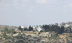
Burham, Ramallah
Burham (Arabic: بُرهام) is a Palestinian village in the Ramallah and al-Bireh Governorate located twelve kilometers north of Ramallah. The largest nearby town is Bir Zeit located to the southeast. The average elevation of Burham is 680 meters above sea level.[3] The village was established during the Byzantine Empire rule over Palestine.[4]
Burham | |
|---|---|
Local Development Committee | |
| Arabic transcription(s) | |
| • Arabic | بُرهام |
| • Latin | Boorhem (official) Kh. Miriam[1] (unofficial) |
 Burham mosque | |
 Burham Location of Burham within Palestine | |
| Coordinates: 31°59′21″N 35°10′29″E | |
| Palestine grid | 166/155 |
| State | State of Palestine |
| Governorate | Ramallah and al-Bireh |
| Government | |
| • Type | Local Development Committee |
| Area | |
| • Total | 1,589 dunams (1.6 km2 or 0.6 sq mi) |
| Population (2007) | |
| • Total | 616 |
| • Density | 390/km2 (1,000/sq mi) |
| Name meaning | Khurbet Burheim; The ruin of Burheim, from personal name[2] |
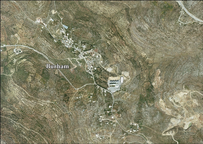
Location
Burham is located 9.8 km north of Ramallah. It is bordered by 'Atara and Bir Zeit to the east, Umm Safa and Jibiya to the north, Kobar to the west, and Bir Zeit and Kobar to the south.[5]
History
Sherds from the Roman, Byzantine and Mamluk eras have been found here.[6]
Ottoman era
Sherds from the early Ottoman era have also been found.[6] Under the name of Dayr Burhan it was listed in the 1538-1539 census.[7]
In 1838 it was noted as a Muslim village in the Bani Zeid administrative region.[8]
In 1863 Victor Guérin noted that it was divided into three parts. He further noted "an ancient rock-cut tomb consisting of a rough sepulchral chamber containing only one koka, and preceded by a vestibule. Here and there are old foundations built of badly quarried stones. There are also remains, probably of an ancient church."[9]
An official Ottoman village list of about 1870 showed that it had a total of 14 houses and a population of 69, though the population count included men, only.[10][11]
In 1882, the PEF's Survey of Western Palestine (SWP) described Khurbet Burheim as: "A few houses on high ground."[12] They further noted that it was "A ruined village, with caves. It is still inhabited by a few peasants."[1]
British Mandate era
In the 1922 census of Palestine conducted by the British Mandate authorities, Burham had a population of 74 Muslims,[13] increasing at the time of the 1931 census to 122, still all Muslim, in 26 houses.[14]
In the 1945 statistics, the population was 150 Muslims,[15] while the total land area was 1,589 dunams, according to an official land and population survey.[16] Of this, 191 were for plantations and irrigable land, 787 for cereals,[17] while 6 dunams were classified as built-up areas.[18]
Jordanian era
In the wake of the 1948 Arab–Israeli War, and after the 1949 Armistice Agreements, Burham came under Jordanian rule.
The Jordanian census of 1961 found 167 inhabitants.[19]
Post-1967
Since the Six-Day War in 1967, Burham has been under Israeli occupation.
After the 1995 accords, 98% of village land is defined as Area B land, while the remaining 2% is defined as Area C.[20]
According to the Palestinian Central Bureau of Statistics, Burham had a population of 565 in mid-year 2006.[21] In the 2007 census by the PCBS, there were 616 people living in the town.[22]
See also
References
- Conder and Kitchener, 1882, SWP II, p. 330
- Palmer, 1881, p. 233
- Welcome to Burham
- Taha, Hamdan, 2002: The Sanctuary of Sheikh al-Qatrawani, Studium Biblicum Franciscanum - Jerusalem
- Burham village profile, ARIJ, p. 4
- Finkelstein and Lederman, 1997, p. 408
- Toledano, 1984, pp. 280, 292, gives the location as 31°59′25″N 35°10′05″E
- Robinson and Smith, 1841, vol 3, Appendix 2, p. 125
- Guérin, 1869, p. 39, as given in Conder and Kitchener, 1882, SWP II, pp. 330-331
- Socin, 1879, p. 145. Also noted it to be in the Bani Zeid region
- Hartmann, 1883, p. 106 also noted 14 houses
- Conder and Kitchener, 1882, SWP II, p. 290
- Barron, 1923, Table VII, Sub-district of Ramallah, p. 16
- Mills, 1932, p. 48
- Government of Palestine, Department of Statistics, 1945, p. 26
- Government of Palestine, Department of Statistics. Village Statistics, April, 1945. Quoted in Hadawi, 1970, p. 64
- Government of Palestine, Department of Statistics. Village Statistics, April, 1945. Quoted in Hadawi, 1970, p. 111
- Government of Palestine, Department of Statistics. Village Statistics, April, 1945. Quoted in Hadawi, 1970, p. 161
- Government of Jordan, Department of Statistics, 1964, p. 24
- Burham village profile, ARIJ, p. 15
- Projected Mid -Year Population for Ramallah & Al Bireh Governorate by Locality 2004- 2006 Palestinian Central Bureau of Statistics.
- 2007 PCBS Census Archived December 10, 2010, at the Wayback Machine Palestinian Central Bureau of Statistics. p.112.
Bibliography
- Barron, J.B., ed. (1923). Palestine: Report and General Abstracts of the Census of 1922. Government of Palestine.
- Conder, C.R.; Kitchener, H.H. (1882). The Survey of Western Palestine: Memoirs of the Topography, Orography, Hydrography, and Archaeology. 2. London: Committee of the Palestine Exploration Fund.
- Finkelstein, I.; Lederman, Zvi, eds. (1997). Highlands of many cultures. Tel Aviv: Institute of Archaeology of Tel Aviv University Publications Section. ISBN 965-440-007-3.
- Government of Jordan, Department of Statistics (1964). First Census of Population and Housing. Volume I: Final Tables; General Characteristics of the Population (PDF).
- Government of Palestine, Department of Statistics (1945). Village Statistics, April, 1945.
- Guérin, V. (1869). Description Géographique Historique et Archéologique de la Palestine (in French). 1: Judee, pt. 3. Paris: L'Imprimerie Nationale.
- Hadawi, S. (1970). Village Statistics of 1945: A Classification of Land and Area ownership in Palestine. Palestine Liberation Organization Research Center.
- Hartmann, M. (1883). "Die Ortschaftenliste des Liwa Jerusalem in dem türkischen Staatskalender für Syrien auf das Jahr 1288 der Flucht (1871)". Zeitschrift des Deutschen Palästina-Vereins. 6: 102–149.
- Mills, E., ed. (1932). Census of Palestine 1931. Population of Villages, Towns and Administrative Areas. Jerusalem: Government of Palestine.
- Palmer, E.H. (1881). The Survey of Western Palestine: Arabic and English Name Lists Collected During the Survey by Lieutenants Conder and Kitchener, R. E. Transliterated and Explained by E.H. Palmer. Committee of the Palestine Exploration Fund.
- Robinson, E.; Smith, E. (1841). Biblical Researches in Palestine, Mount Sinai and Arabia Petraea: A Journal of Travels in the year 1838. 3. Boston: Crocker & Brewster.
- Socin, A. (1879). "Alphabetisches Verzeichniss von Ortschaften des Paschalik Jerusalem". Zeitschrift des Deutschen Palästina-Vereins. 2: 135–163.
- Toledano, E. (1984). "The Sanjaq of Jerusalem in the Sixteenth Century: Aspects of Topography and Population". Archivum Ottomanicum. 9: 279–319.
External links
- Welcome to Burham
- Survey of Western Palestine, Map 14: IAA, Wikimedia commons
- Burham village (fact sheet), Applied Research Institute–Jerusalem (ARIJ)
- Burham village profile, ARIJ
- Burham, aerial photo, ARIJ
- Locality Development Priorities and Needs in Burham Village, ARIJ
- Untold stories: Said Arouri, IMEU
| Cities |  | |
|---|---|---|
| Municipalities |
| |
| Village councils |
| |
| Refugee camps | ||