Theillay
Theillay is a commune of the Loir-et-Cher department in central France.
Theillay | |
|---|---|
Commune | |
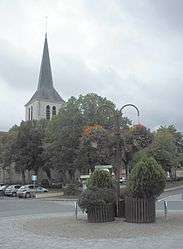 Church of Saint-Sulpice | |
.svg.png) Coat of arms | |
Location of Theillay 
| |
 Theillay  Theillay | |
| Coordinates: 47°18′52″N 2°02′28″E | |
| Country | France |
| Region | Centre-Val de Loire |
| Department | Loir-et-Cher |
| Arrondissement | Romorantin-Lanthenay |
| Canton | Selles-sur-Cher |
| Intercommunality | Sologne des rivières |
| Government | |
| • Mayor (2014–2020) | Gérard Chopin |
| Area 1 | 96.38 km2 (37.21 sq mi) |
| Population (2017-01-01)[1] | 1,260 |
| • Density | 13/km2 (34/sq mi) |
| Time zone | UTC+01:00 (CET) |
| • Summer (DST) | UTC+02:00 (CEST) |
| INSEE/Postal code | 41256 /41300 |
| Elevation | 96–168 m (315–551 ft) |
| 1 French Land Register data, which excludes lakes, ponds, glaciers > 1 km2 (0.386 sq mi or 247 acres) and river estuaries. | |
Geography
The Rère flows west through the northern part of the commune.
Population
| Historical population | ||
|---|---|---|
| Year | Pop. | ±% |
| 1793 | 1,227 | — |
| 1806 | 1,201 | −2.1% |
| 1821 | 1,381 | +15.0% |
| 1831 | 1,374 | −0.5% |
| 1841 | 1,374 | +0.0% |
| 1851 | 1,403 | +2.1% |
| 1861 | 1,362 | −2.9% |
| 1872 | 1,480 | +8.7% |
| 1881 | 1,720 | +16.2% |
| 1891 | 1,803 | +4.8% |
| 1901 | 1,850 | +2.6% |
| 1911 | 1,832 | −1.0% |
| 1921 | 1,572 | −14.2% |
| 1931 | 1,440 | −8.4% |
| 1946 | 1,330 | −7.6% |
| 1954 | 1,221 | −8.2% |
| 1962 | 1,332 | +9.1% |
| 1968 | 1,288 | −3.3% |
| 1975 | 1,198 | −7.0% |
| 1982 | 1,245 | +3.9% |
| 1990 | 1,354 | +8.8% |
| 1999 | 1,293 | −4.5% |
| 2006 | 1,267 | −2.0% |
| 2015 | 1,308 | +3.2% |
See also
| Wikimedia Commons has media related to Theillay. |
| Authority control |
|
|---|
- "Populations légales 2017". INSEE. Retrieved 6 January 2020.
This article is issued from Wikipedia. The text is licensed under Creative Commons - Attribution - Sharealike. Additional terms may apply for the media files.