Gièvres
Gièvres is a commune in the Loir-et-Cher department of central France.
Gièvres | |
|---|---|
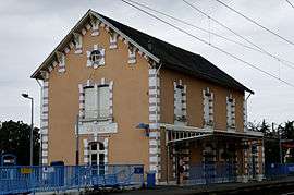 Railway station | |
.svg.png) Coat of arms | |
Location of Gièvres 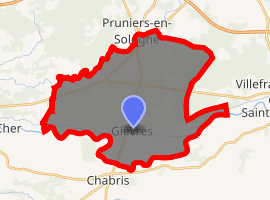
| |
 Gièvres  Gièvres | |
| Coordinates: 47°16′38″N 1°40′11″E | |
| Country | France |
| Region | Centre-Val de Loire |
| Department | Loir-et-Cher |
| Arrondissement | Romorantin-Lanthenay |
| Canton | Selles-sur-Cher |
| Intercommunality | Cher - Sologne |
| Government | |
| • Mayor (2014&ndas20) | Robert Mougne |
| Area 1 | 38.05 km2 (14.69 sq mi) |
| Population (2017-01-01)[1] | 2,396 |
| • Density | 63/km2 (160/sq mi) |
| Time zone | UTC+01:00 (CET) |
| • Summer (DST) | UTC+02:00 (CEST) |
| INSEE/Postal code | 41097 /41130 |
| Elevation | 72–102 m (236–335 ft) |
| 1 French Land Register data, which excludes lakes, ponds, glaciers > 1 km2 (0.386 sq mi or 247 acres) and river estuaries. | |
Population
| Historical population | ||
|---|---|---|
| Year | Pop. | ±% |
| 1793 | 544 | — |
| 1806 | 531 | −2.4% |
| 1821 | 885 | +66.7% |
| 1831 | 896 | +1.2% |
| 1841 | 1,010 | +12.7% |
| 1851 | 1,057 | +4.7% |
| 1861 | 1,140 | +7.9% |
| 1872 | 1,225 | +7.5% |
| 1881 | 1,259 | +2.8% |
| 1891 | 1,265 | +0.5% |
| 1901 | 1,298 | +2.6% |
| 1911 | 1,321 | +1.8% |
| 1921 | 2,166 | +64.0% |
| 1931 | 1,319 | −39.1% |
| 1946 | 1,185 | −10.2% |
| 1954 | 1,438 | +21.4% |
| 1962 | 1,292 | −10.2% |
| 1968 | 1,254 | −2.9% |
| 1975 | 1,534 | +22.3% |
| 1982 | 1,666 | +8.6% |
| 1990 | 1,767 | +6.1% |
| 1999 | 1,999 | +13.1% |
| 2008 | 2,217 | +10.9% |
| 2013 | 2,419 | +9.1% |
References
- "Populations légales 2017". INSEE. Retrieved 6 January 2020.
| Wikimedia Commons has media related to Gièvres. |
| Authority control |
|---|
This article is issued from Wikipedia. The text is licensed under Creative Commons - Attribution - Sharealike. Additional terms may apply for the media files.