Arrondissement of Romorantin-Lanthenay
The arrondissement of Romorantin-Lanthenay is an arrondissement of France in the Loir-et-Cher department, in the Centre-Val de Loire region. It has 74 communes.[1] Its population is 112,145 (2016), and its area is 2,670.9 km2 (1,031.2 sq mi).[1]
Romorantin-Lanthenay | |
|---|---|
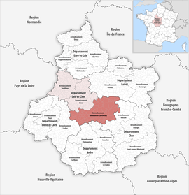 Location within the region Centre-Val de Loire | |
| Country | France |
| Region | Centre-Val de Loire |
| Department | Loir-et-Cher |
| No. of communes | 74 |
| Subprefecture | Romorantin-Lanthenay |
| Area | |
| • Total | 2,670.9 km2 (1,031.2 sq mi) |
| Population (2016) | |
| • Total | 112,145 |
| • Density | 42/km2 (110/sq mi) |
| INSEE code | 413 |
Composition
The communes of the arrondissement of Romorantin-Lanthenay are:[2]
- Angé (41002)
- Billy (41016)
- Chaon (41036)
- La Chapelle-Montmartin (41038)
- Châteauvieux (41042)
- Châtillon-sur-Cher (41043)
- Châtres-sur-Cher (41044)
- Chaumont-sur-Tharonne (41046)
- Chémery (41049)
- Chissay-en-Touraine (41051)
- Choussy (41054)
- Le Controis-en-Sologne (41059)
- Couddes (41062)
- Couffy (41063)
- Courmemin (41068)
- Dhuizon (41074)
- Faverolles-sur-Cher (41080)
- La Ferté-Beauharnais (41083)
- La Ferté-Imbault (41084)
- Fresnes (41094)
- Gièvres (41097)
- Gy-en-Sologne (41099)
- Lamotte-Beuvron (41106)
- Langon-sur-Cher (41110)
- Lassay-sur-Croisne (41112)
- Loreux (41118)
- Maray (41122)
- Marcilly-en-Gault (41125)
- Mareuil-sur-Cher (41126)
- La Marolle-en-Sologne (41127)
- Méhers (41132)
- Mennetou-sur-Cher (41135)
- Meusnes (41139)
- Millançay (41140)
- Monthou-sur-Cher (41146)
- Montrichard-Val-de-Cher (41151)
- Montrieux-en-Sologne (41152)
- Mur-de-Sologne (41157)
- Neung-sur-Beuvron (41159)
- Nouan-le-Fuzelier (41161)
- Noyers-sur-Cher (41164)
- Oisly (41166)
- Orçay (41168)
- Pierrefitte-sur-Sauldre (41176)
- Pontlevoy (41180)
- Pouillé (41181)
- Pruniers-en-Sologne (41185)
- Romorantin-Lanthenay (41194)
- Rougeou (41195)
- Saint-Aignan (41198)
- Saint-Georges-sur-Cher (41211)
- Saint-Julien-de-Chédon (41217)
- Saint-Julien-sur-Cher (41218)
- Saint-Loup (41222)
- Saint-Romain-sur-Cher (41229)
- Saint-Viâtre (41231)
- Salbris (41232)
- Sassay (41237)
- Seigy (41239)
- Selles-Saint-Denis (41241)
- Selles-sur-Cher (41242)
- Soings-en-Sologne (41247)
- Souesmes (41249)
- Souvigny-en-Sologne (41251)
- Theillay (41256)
- Thésée (41258)
- Vallières-les-Grandes (41267)
- Veilleins (41268)
- Vernou-en-Sologne (41271)
- Villefranche-sur-Cher (41280)
- Villeherviers (41282)
- Villeny (41285)
- Vouzon (41296)
- Yvoy-le-Marron (41297)
History
The arrondissement of Romorantin-Lanthenay was created in 1800, disbanded in 1926 and restored in 1943.[3] In 2007 it absorbed the canton of Saint-Aignan from the arrondissement of Blois.[3] At the January 2017 reorganisation of the arrondissements of Loir-et-Cher, it gained 17 communes from the arrondissement of Blois, and it lost three communes to the arrondissement of Blois.[4] In January 2019 it gained the commune Courmemin from the arrondissement of Romorantin-Lanthenay.[5]
As a result of the reorganisation of the cantons of France which came into effect in 2015, the borders of the cantons are no longer related to the borders of the arrondissements. The cantons of the arrondissement of Romorantin-Lanthenay were, as of January 2015:[6]
- Lamotte-Beuvron
- Mennetou-sur-Cher
- Neung-sur-Beuvron
- Romorantin-Lanthenay-Nord
- Romorantin-Lanthenay-Sud
- Salbris
- Selles-sur-Cher
References
- "Comparateur de territoire, géographie au 01/01/2019". INSEE. Retrieved 2019-10-01.
- "Arrondissement de Romorantin-Lanthenay (413)". INSEE. Retrieved 2019-10-01.
- Historique de Loir-et-Cher
- "Arrêté préfectoral, 28 December 2016" (PDF). pp. 11–18. Retrieved 2019-10-21.
- Commune de Courmemin (41068), INSEE
- "Populations légales 2012" (PDF). INSEE. December 2014. Retrieved 2019-10-21.