Les Montils
Les Montils is a commune in the Loir-et-Cher department of central France.
Les Montils | |
|---|---|
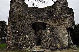 Ruins of a tower | |
.svg.png) Coat of arms | |
Location of Les Montils 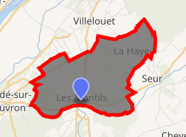
| |
 Les Montils  Les Montils | |
| Coordinates: 47°29′46″N 1°17′52″E | |
| Country | France |
| Region | Centre-Val de Loire |
| Department | Loir-et-Cher |
| Arrondissement | Blois |
| Canton | Blois-3 |
| Intercommunality | Communauté d'agglomération de Blois |
| Government | |
| • Mayor (2014–2020) | Didier Coudert |
| Area 1 | 9.27 km2 (3.58 sq mi) |
| Population (2017-01-01)[1] | 1,943 |
| • Density | 210/km2 (540/sq mi) |
| Time zone | UTC+01:00 (CET) |
| • Summer (DST) | UTC+02:00 (CEST) |
| INSEE/Postal code | 41147 /41120 |
| Elevation | 62–101 m (203–331 ft) (avg. 92 m or 302 ft) |
| 1 French Land Register data, which excludes lakes, ponds, glaciers > 1 km2 (0.386 sq mi or 247 acres) and river estuaries. | |
Geography
Les Montils is at the edge of the Sologne, at an altitude of 80 m (approx.). This town is bordered by the Cosson in the north, through the Beuvron. To the west of the village, the Bièvre flows into Beuvron. At this point, there are numerous beavers.
Tourism
- Recreation area Masnières
- A model railway with a train that can be ridden by visitors in the summer months.
Sights
- From the old village remains a strong tower, the tower of Montils, an arch and some walls.
- Château de Frileuse
Population
| Historical population | ||
|---|---|---|
| Year | Pop. | ±% |
| 1962 | 707 | — |
| 1968 | 717 | +1.4% |
| 1975 | 808 | +12.7% |
| 1982 | 1,046 | +29.5% |
| 1990 | 1,196 | +14.3% |
| 1999 | 1,436 | +20.1% |
| 2007 | 1,693 | +17.9% |
Personalities
- Antonio de La Gandara (1861–1917), painter
References
- "Populations légales 2017". INSEE. Retrieved 6 January 2020.
| Wikimedia Commons has media related to Les Montils. |
| Authority control |
|
|---|
This article is issued from Wikipedia. The text is licensed under Creative Commons - Attribution - Sharealike. Additional terms may apply for the media files.