Monthou-sur-Cher
Monthou-sur-Cher is a commune in the Loir-et-Cher department of central France.
Monthou-sur-Cher | |
|---|---|
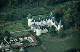 Chateau of Gué-Péan | |
Location of Monthou-sur-Cher 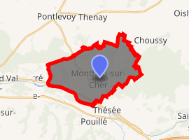
| |
 Monthou-sur-Cher  Monthou-sur-Cher | |
| Coordinates: 47°20′51″N 1°17′46″E | |
| Country | France |
| Region | Centre-Val de Loire |
| Department | Loir-et-Cher |
| Arrondissement | Romorantin-Lanthenay |
| Canton | Montrichard |
| Intercommunality | Du Cher à la Loire |
| Government | |
| • Mayor (2014–2020) | Jean-François Marinier |
| Area 1 | 20.16 km2 (7.78 sq mi) |
| Population (2017-01-01)[1] | 964 |
| • Density | 48/km2 (120/sq mi) |
| Time zone | UTC+01:00 (CET) |
| • Summer (DST) | UTC+02:00 (CEST) |
| INSEE/Postal code | 41146 /41400 |
| Elevation | 61–135 m (200–443 ft) (avg. 67 m or 220 ft) |
| 1 French Land Register data, which excludes lakes, ponds, glaciers > 1 km2 (0.386 sq mi or 247 acres) and river estuaries. | |
Population
| Historical population | ||
|---|---|---|
| Year | Pop. | ±% |
| 1793 | 801 | — |
| 1806 | 921 | +15.0% |
| 1821 | 982 | +6.6% |
| 1831 | 1,071 | +9.1% |
| 1841 | 1,239 | +15.7% |
| 1851 | 1,413 | +14.0% |
| 1861 | 1,170 | −17.2% |
| 1872 | 1,205 | +3.0% |
| 1881 | 1,223 | +1.5% |
| 1891 | 1,191 | −2.6% |
| 1901 | 1,152 | −3.3% |
| 1911 | 1,130 | −1.9% |
| 1921 | 1,007 | −10.9% |
| 1931 | 953 | −5.4% |
| 1946 | 927 | −2.7% |
| 1954 | 924 | −0.3% |
| 1962 | 898 | −2.8% |
| 1968 | 836 | −6.9% |
| 1975 | 805 | −3.7% |
| 1982 | 850 | +5.6% |
| 1990 | 867 | +2.0% |
| 1999 | 902 | +4.0% |
| 2004 | 932 | +3.3% |
| 2014 | 973 | +4.4% |
References
- "Populations légales 2017". INSEE. Retrieved 6 January 2020.
| Wikimedia Commons has media related to Monthou-sur-Cher. |
| Authority control |
|
|---|
This article is issued from Wikipedia. The text is licensed under Creative Commons - Attribution - Sharealike. Additional terms may apply for the media files.