Thésée, Loir-et-Cher
Thésée is a commune of the Loir-et-Cher department in central France.
Thésée | |
|---|---|
Commune | |
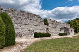 Bâtiment des Maselles, Gallo-Roman ruins | |
Location of Thésée 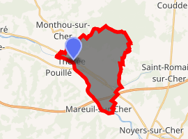
| |
 Thésée  Thésée | |
| Coordinates: 47°19′37″N 1°18′16″E | |
| Country | France |
| Region | Centre-Val de Loire |
| Department | Loir-et-Cher |
| Arrondissement | Romorantin-Lanthenay |
| Canton | Saint-Aignan |
| Intercommunality | Val de Cher - Saint-Aignan |
| Government | |
| • Mayor (2014–2020) | Daniel Charluteau |
| Area 1 | 17.61 km2 (6.80 sq mi) |
| Population (2017-01-01)[1] | 1,132 |
| • Density | 64/km2 (170/sq mi) |
| Time zone | UTC+01:00 (CET) |
| • Summer (DST) | UTC+02:00 (CEST) |
| INSEE/Postal code | 41258 /41140 |
| Elevation | 61–122 m (200–400 ft) (avg. 70 m or 230 ft) |
| 1 French Land Register data, which excludes lakes, ponds, glaciers > 1 km2 (0.386 sq mi or 247 acres) and river estuaries. | |
Population
| Historical population | ||
|---|---|---|
| Year | Pop. | ±% |
| 1793 | 750 | — |
| 1806 | 837 | +11.6% |
| 1821 | 838 | +0.1% |
| 1831 | 916 | +9.3% |
| 1841 | 944 | +3.1% |
| 1851 | 1,090 | +15.5% |
| 1861 | 1,278 | +17.2% |
| 1872 | 1,366 | +6.9% |
| 1881 | 1,435 | +5.1% |
| 1891 | 1,385 | −3.5% |
| 1901 | 1,406 | +1.5% |
| 1911 | 1,318 | −6.3% |
| 1921 | 1,184 | −10.2% |
| 1931 | 1,108 | −6.4% |
| 1946 | 1,079 | −2.6% |
| 1965 | 1,034 | −4.2% |
| 1962 | 1,035 | +0.1% |
| 1968 | 1,117 | +7.9% |
| 1975 | 1,075 | −3.8% |
| 1982 | 1,111 | +3.3% |
| 1990 | 1,074 | −3.3% |
| 1999 | 1,123 | +4.6% |
| 2004 | 1,206 | +7.4% |
| 2015 | 1,152 | −4.5% |
References
- "Populations légales 2017". INSEE. Retrieved 6 January 2020.
| Wikimedia Commons has media related to Thésée (Loir-et-Cher). |
| Authority control |
|
|---|
This article is issued from Wikipedia. The text is licensed under Creative Commons - Attribution - Sharealike. Additional terms may apply for the media files.