Thaumiers
Thaumiers is a commune in the Cher department in the Centre-Val de Loire region of France.
Thaumiers | |
|---|---|
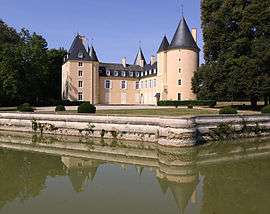 The Château of La Forêt | |
Location of Thaumiers 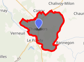
| |
 Thaumiers  Thaumiers | |
| Coordinates: 46°49′20″N 2°39′21″E | |
| Country | France |
| Region | Centre-Val de Loire |
| Department | Cher |
| Arrondissement | Saint-Amand-Montrond |
| Canton | Dun-sur-Auron |
| Intercommunality | CC Le Dunois |
| Government | |
| • Mayor (2008–2014) | Philippe de Bonneval |
| Area 1 | 27.33 km2 (10.55 sq mi) |
| Population (2017-01-01)[1] | 417 |
| • Density | 15/km2 (40/sq mi) |
| Time zone | UTC+01:00 (CET) |
| • Summer (DST) | UTC+02:00 (CEST) |
| INSEE/Postal code | 18261 /18210 |
| Elevation | 165–236 m (541–774 ft) (avg. 181 m or 594 ft) |
| 1 French Land Register data, which excludes lakes, ponds, glaciers > 1 km2 (0.386 sq mi or 247 acres) and river estuaries. | |
Geography
An area of forestry and farming comprising the village and several hamlets situated about 21 miles (34 km) southeast of Bourges at the junction of the D41 with the D92 and D943 roads. The Auron River forms the western and southern boundaries of the commune.
Population
| Historical population | ||
|---|---|---|
| Year | Pop. | ±% |
| 1962 | 487 | — |
| 1968 | 512 | +5.1% |
| 1975 | 427 | −16.6% |
| 1982 | 397 | −7.0% |
| 1990 | 383 | −3.5% |
| 1999 | 382 | −0.3% |
| 2008 | 416 | +8.9% |
Sights
See also
References
- "Populations légales 2017". INSEE. Retrieved 6 January 2020.
External links
| Wikimedia Commons has media related to Thaumiers. |
- Annuaire Mairie website (in French)
| Authority control |
|
|---|
This article is issued from Wikipedia. The text is licensed under Creative Commons - Attribution - Sharealike. Additional terms may apply for the media files.