Lunery
Lunery is a commune in the Cher department in the Centre-Val de Loire region of France.
Lunery | |
|---|---|
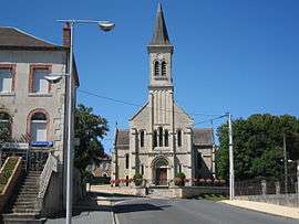 The church of Saint-Albert, in Lunery | |
Location of Lunery 
| |
 Lunery  Lunery | |
| Coordinates: 46°56′10″N 2°16′19″E | |
| Country | France |
| Region | Centre-Val de Loire |
| Department | Cher |
| Arrondissement | Bourges |
| Canton | Chârost |
| Intercommunality | Fercher - Pays florentais |
| Government | |
| • Mayor (2008–2014) | Claude Foutiau |
| Area 1 | 32.87 km2 (12.69 sq mi) |
| Population (2017-01-01)[1] | 1,570 |
| • Density | 48/km2 (120/sq mi) |
| Time zone | UTC+01:00 (CET) |
| • Summer (DST) | UTC+02:00 (CEST) |
| INSEE/Postal code | 18133 /18400 |
| Elevation | 121–173 m (397–568 ft) (avg. 135 m or 443 ft) |
| 1 French Land Register data, which excludes lakes, ponds, glaciers > 1 km2 (0.386 sq mi or 247 acres) and river estuaries. | |
Geography
A forestry and farming area comprising two villages and several hamlets situated in the valley of the river Cher, some 12 miles (19 km) southwest of Bourges, at the junction of the D103, D88, D35 and the D27 roads. The commune is served by a TER railway link to Bourges.
Population
| Historical population | ||
|---|---|---|
| Year | Pop. | ±% |
| 1962 | 2,266 | — |
| 1968 | 2,329 | +2.8% |
| 1975 | 2,440 | +4.8% |
| 1982 | 2,021 | −17.2% |
| 1990 | 1,665 | −17.6% |
| 1999 | 1,487 | −10.7% |
| 2008 | 1,469 | −1.2% |
Sights
- The church of St. Privé, dating from the thirteenth century.
- The chateau at Champroy.
- The church of St. Albert at Rosières, dating from the nineteenth century.
- The fifteenth-century manorhouse de La Vergne.
- A watermill, in ruins.
See also
References
- "Populations légales 2017". INSEE. Retrieved 6 January 2020.
| Wikimedia Commons has media related to Lunery. |
| Authority control |
|
|---|
This article is issued from Wikipedia. The text is licensed under Creative Commons - Attribution - Sharealike. Additional terms may apply for the media files.