Marmagne, Cher
Marmagne is a commune in the Cher department in the Centre-Val de Loire region of France.
Marmagne | |
|---|---|
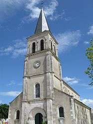 The church in Marmagne | |
Location of Marmagne 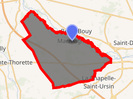
| |
 Marmagne  Marmagne | |
| Coordinates: 47°06′08″N 2°17′05″E | |
| Country | France |
| Region | Centre-Val de Loire |
| Department | Cher |
| Arrondissement | Bourges |
| Canton | Saint-Doulchard |
| Intercommunality | CA Bourges Plus |
| Government | |
| • Mayor (2008–2014) | Aymar de Germay |
| Area 1 | 37.66 km2 (14.54 sq mi) |
| Population (2017-01-01)[1] | 1,960 |
| • Density | 52/km2 (130/sq mi) |
| Time zone | UTC+01:00 (CET) |
| • Summer (DST) | UTC+02:00 (CEST) |
| INSEE/Postal code | 18138 /18500 |
| Elevation | 113–149 m (371–489 ft) (avg. 138 m or 453 ft) |
| 1 French Land Register data, which excludes lakes, ponds, glaciers > 1 km2 (0.386 sq mi or 247 acres) and river estuaries. | |
Geography
A farming area comprising a large village and several small hamlets situated by the banks of the Yèvre river and the canal de Berry, some 5 miles (8.0 km) west of Bourges at the junction of the D160, D214 and the D107 roads. The A71 autoroute cuts across the middle of the commune’s territory, which is also served by a TER railway.
Population
| Historical population | ||
|---|---|---|
| Year | Pop. | ±% |
| 1962 | 1,319 | — |
| 1968 | 1,321 | +0.2% |
| 1975 | 1,684 | +27.5% |
| 1982 | 1,774 | +5.3% |
| 1990 | 1,908 | +7.6% |
| 1999 | 1,941 | +1.7% |
| 2008 | 2,003 | +3.2% |
Sights
- The church of St. Denis, dating from the thirteenth century.
- Several seventeenth-century buildings.
- The seventeenth-century chateau of Marmagne.
- The thirteenth-century abbey at Beauvoir.
See also
References
- "Populations légales 2017". INSEE. Retrieved 6 January 2020.
| Wikimedia Commons has media related to Marmagne (Cher). |
| Authority control |
|
|---|
This article is issued from Wikipedia. The text is licensed under Creative Commons - Attribution - Sharealike. Additional terms may apply for the media files.