Marseilles-lès-Aubigny
Marseilles-lès-Aubigny is a commune in the Cher department in the Centre-Val de Loire region of France.
Marseilles-lès-Aubigny | |
|---|---|
 Loire lateral canal | |
Location of Marseilles-lès-Aubigny 
| |
 Marseilles-lès-Aubigny  Marseilles-lès-Aubigny | |
| Coordinates: 47°04′06″N 3°00′50″E | |
| Country | France |
| Region | Centre-Val de Loire |
| Department | Cher |
| Arrondissement | Bourges |
| Canton | Avord |
| Government | |
| • Mayor (2014–2020) | Jean-Pierre Renault |
| Area 1 | 9.88 km2 (3.81 sq mi) |
| Population (2017-01-01)[1] | 657 |
| • Density | 66/km2 (170/sq mi) |
| Time zone | UTC+01:00 (CET) |
| • Summer (DST) | UTC+02:00 (CEST) |
| INSEE/Postal code | 18139 /18320 |
| Elevation | 157–198 m (515–650 ft) (avg. 180 m or 590 ft) |
| 1 French Land Register data, which excludes lakes, ponds, glaciers > 1 km2 (0.386 sq mi or 247 acres) and river estuaries. | |
Geography
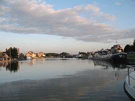
A forestry and farming area comprising the village and several hamlets situated by the banks of the rivers Aubois and Loire, some 25 miles (40 km) east of Bourges, at the junction of the D44 and the D81 roads. The commune has a small port on the Loire lateral canal. There is a canal boatyard with dry dock in the basin. The village grew up because of the canal traffic. The junction of the Canal Lateral a la Loire, a through route from the Channel to the Mediterranean, with the Canal de Berry. The canal de Berry was a small scale canal and goods needed transferring from the larger Freycinet size peniches used on the Canal de Berry to the smaller Berrichon peniches. It ran from this village to join the Loire at Tours.
Population
| Historical population | ||
|---|---|---|
| Year | Pop. | ±% |
| 1962 | 913 | — |
| 1968 | 963 | +5.5% |
| 1975 | 917 | −4.8% |
| 1982 | 876 | −4.5% |
| 1990 | 802 | −8.4% |
| 1999 | 691 | −13.8% |
| 2008 | 687 | −0.6% |
See also
References
- "Populations légales 2017". INSEE. Retrieved 6 January 2020.
External links
| Wikimedia Commons has media related to Marseilles-lès-Aubigny. |
- Official website of Marseilles-lès-Aubigny (in French)
| Authority control |
|
|---|