Teknaf Upazila
Teknaf (Bengali: টেকনাফ Ṭeknaf) is an Upazila of Cox's Bazar District in the Division of Chittagong, Bangladesh. It forms the southernmost point in mainland Bangladesh (St. Martin's Island is the southernmost point). The name of the region comes from the Naf River which forms the Eastern boundary of the upazila. It shares the border with Burma.
Teknaf টেকনাফ | |
|---|---|
Upazila | |
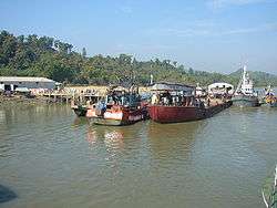 View of the Launch Terminal of Teknaf Bangladesh | |
 Teknaf Location in Bangladesh | |
| Coordinates: 20°52′N 92°18′E | |
| Country | |
| Division | Chittagong Division |
| District | Cox's Bazar District |
| Area | |
| • Total | 388.68 km2 (150.07 sq mi) |
| Population (1991) | |
| • Total | 152,557 |
| • Density | 393/km2 (1,020/sq mi) |
| Time zone | UTC+6 (BST) |
| Website | http://teknaf.coxsbazar.gov.bd |
Geography
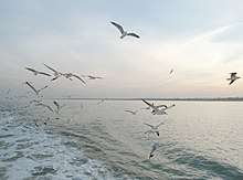
Teknaf is located at 20.8667°N 92.3000°E. It has 23, 675 households and a total area of 388.68 km². The tidal range at the Teknaf coastal area is strong influenced by the Naaf river estuary. The area has a warm tropical climate and sufficient rainfall to enable it to support a wide biological diversity.
Demographics
According to the 1991 Bangladesh census, Teknaf had a population of 152,557. Males constituted 51.81% of the population, and females 48.19%. The population aged 18 or over was 64,417. Teknaf had an average literacy rate of 16.6% (7+ years), against the national average of 32.4%.[1]
Administration
Teknaf has 6 Unions/Wards, 13 Mauzas/Mahallas, and 133 villages.
- Teknaf Union
- Nhilla Union
- Baharchhara Union
- Sabrang Union
- Whykong Union
- St. Martins Dwip
Education
Its historical educational institutions include Teknaf Degree College, Hnilla High School, Teknaf Pilot High School, Alhaj Ali Achiya School & College, Nhilla Girls High School, Rangikhali Khadizatul Kubra (Ra.) Mohila Dakhil Madrasah,Rangikhali Darul Ulum Fazil Degree Madrasah, Hnilla Ideal Government Primary School and Teknaf Govt. Primary School, Pankhali Govt. Primary School.
Geography
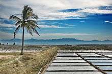
Teknaf Peninsula is one of the longest sandy beach ecosystems (80 km) in the world. It represents a transitional ground for the fauna of the Indo-Himalayan and Indo-Malayan ecological sub-regions. Important habitats at the site include mangrove, mudflats, beaches and sand dunes, canals and lagoons and marine habitat. Mangrove forest occurs in Teknaf peninsula both as natural forest with planted stands and mostly distributed in the inter-tidal zone. The Teknaf peninsula mangroves supports the habitat of 161 different species of fish.[2] Teknaf reserved forest is one of the oldest reserved forests in Bangladesh.[3]
See also
- Rohingya refugees in Bangladesh — primarily in Teknaf Upazila & Cox's Bazar District.
- Cox's Bazar District topics
- List of Upazilas of Bangladesh
- Upazilas of Chittagong District
References
- "Population Census Wing, BBS". Archived from the original on 2005-03-27. Retrieved November 10, 2006.
- Chowdhury, N. Shah Nawaz; Hossain, M. Shahadat; Das, Nani Gopal; Barua, Prabal (2010-09-25). "Environmental variables and fisheries diversity of the Naaf River Estuary, Bangladesh" (PDF). Journal of Coastal Conservation. 15 (1): 163–180. doi:10.1007/s11852-010-0130-3. Retrieved 2011-01-01.
- "Teknef forest".
External links

- Mainuddin, Md. (2012). "Teknaf Upazila". In Islam, Sirajul; Jamal, Ahmed A. (eds.). Banglapedia: National Encyclopedia of Bangladesh (Second ed.). Asiatic Society of Bangladesh.
| Upazila/Thana: | ||
|---|---|---|
Capital: Chattogram | ||
| Bandarban District | 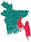 | |
| Brahmanbaria District | ||
| Chandpur District | ||
| Chattogram District | ||
| Cumilla District |
| |
| Cox's Bazar District | ||
| Feni District | ||
| Khagrachari District |
| |
| Lakshmipur District | ||
| Noakhali District | ||
| Rangamati District | ||