Langadu Upazila
Langadu (Bengali: লংগদু) is an Upazila of Rangamati District[1] in the Division of Chittagong, Bangladesh.
Langadu লংগদু | |
|---|---|
Upazila | |
 Langadu Location in Bangladesh | |
| Coordinates: 22°57′N 92°9′E | |
| Country | |
| Division | Chittagong Division |
| District | Rangamati District |
| Area | |
| • Total | 388.5 km2 (150.0 sq mi) |
| Population (1991) | |
| • Total | 54,490 |
| • Density | 140/km2 (360/sq mi) |
| Time zone | UTC+6 (BST) |
| Website | Official Map of Langadu |
Geography
Langadu is located at 22.9500°N 92.1500°E . It has 10571 households and total area 388.5 km².
Demographics
As of the 1991 Bangladesh census, Langadu has a population of 54490. Males constitute 53.01% of the population, and females 46.99%. This Upazila's eighteen up population is 26617. Langadu has an average literacy rate of 27.5% (7+ years).
Unions
There are 7 unions in Langadu:
- Atarokchara
- Mainimukh
- Kalapakujja
- Goilshakhali
- Bagachattor
- Vashannadom
- Langadu
Educational Institutions
- Rabeta Model High school[2]
- Mainimukh model gov.t High School
- Baitush Sharaf Adarsha Dakhil Madrasah
- Goilshakhali Model High School
- Langadu Model College
Administration
Langadu has 7 Unions/Wards, 29 Mauzas/Mahallas, and 131 villages.
See also
- Upazilas of Bangladesh
- Districts of Bangladesh
- Divisions of Bangladesh
References
- Gautam Chandra Modak (2012), "Langadu Upazila", in Sirajul Islam and Ahmed A. Jamal (ed.), Banglapedia: National Encyclopedia of Bangladesh (Second ed.), Asiatic Society of Bangladesh
- "Rabita Model High School - Sohopathi | সহপাঠী". Sohopathi | সহপাঠী. 2017-07-02. Retrieved 2018-12-04.
| Upazila/Thana: | ||
|---|---|---|
Capital: Chattogram | ||
| Bandarban District | 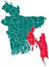 | |
| Brahmanbaria District | ||
| Chandpur District | ||
| Chattogram District | ||
| Cumilla District |
| |
| Cox's Bazar District | ||
| Feni District | ||
| Khagrachari District |
| |
| Lakshmipur District | ||
| Noakhali District | ||
| Rangamati District | ||
This article is issued from Wikipedia. The text is licensed under Creative Commons - Attribution - Sharealike. Additional terms may apply for the media files.