St. Cloud, Florida
St. Cloud is a city in northern Osceola County, Florida, United States. It is on the southern shore of East Lake Tohopekaliga in Central Florida, about 26 miles (41.8 km) southeast of Orlando. The population was 35,183 in the 2010 census, and 54,579 in the 2019 census estimate.[7] The city is part of the Orlando–Kissimmee–Sanford metropolitan area.
St. Cloud, Florida | |
|---|---|
| City of St. Cloud | |
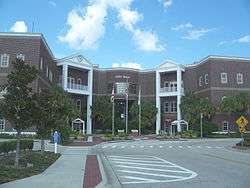 St. Cloud City Hall | |
City logo | |
| Nickname(s): Soldier City | |
| Motto(s): "Celebrating Small Town Life" | |
 Location in Osceola County and the state of Florida | |
| Coordinates: 28°13′50″N 81°17′7″W[1] | |
| Country | United States |
| State | Florida |
| County | Osceola |
| Founded | April 16, 1909[2] |
| Incorporated | January 3, 1911[3] |
| Government | |
| • Type | Council–manager |
| • Mayor | Nathan Blackwell |
| • City manager | William Sturgeon |
| Area | |
| • Total | 18.68 sq mi (48.4 km2) |
| • Land | 18.67 sq mi (48.4 km2) |
| • Water | 0.01 sq mi (0.03 km2) 0.061% |
| Elevation | 75 ft (23 m) |
| Population | |
| • Total | 35,183 |
| • Estimate (2019)[7] | 54,579 |
| • Density | 1,900/sq mi (730/km2) |
| Time zone | UTC-5 (EST) |
| • Summer (DST) | UTC-4 (EDT) |
| ZIP code(s) | 34769, 34771, 34772, 34773 |
| Area code(s) | 321, 407, 689 |
| FIPS code | 12-62625[6] |
| GNIS feature ID | 0290167[5] |
| Website | www |
St. Cloud was founded as a retirement community for Civil War union veterans, and gained the nickname "The Friendly Soldier City".[8]
History
During the 1870s, Hamilton Disston of Philadelphia took an interest in developing the region while on fishing trips with Henry Shelton Sanford, founder of the city of Sanford. Disston contracted with the Florida Internal Improvement Fund, then in receivership, to pay $1 million to offset its Civil War and Reconstruction debt. In exchange, Disston was awarded half the land he drained from the state's swamps. He dug canals and, in 1886–87, established St. Cloud sugarcane plantation, named after St. Cloud, Minnesota, although many longtime locals claim the town was named after Saint-Cloud, France.[9]
Disston opened the Sugar Belt Railway to the South Florida Railroad in 1888 to carry his product to market. But the Panic of 1893 dropped land values, and the Great Freeze of 1894-95 ruined the plantation. Disston returned to Philadelphia, where he died in 1896. The Sugar Belt Railway merged into the South Florida Railroad. An attempt to cultivate rice in the area failed, and for several years the land remained fallow. Then in 1909, the Seminole Land & Investment Company acquired 35,000 acres (14,000 ha) as the site for a Grand Army of the Republic veterans' colony. St. Cloud was selected because of its "health, climate and productiveness of soil." It was first permanently settled in 1909 by William G. King, a real estate manager from Alachua County who had been given the responsibility "to plan, locate and develop a town."
On April 16, 1909, the Kissimmee Valley Gazette announced the "New Town of St. Cloud", a "Soldiers Colony" near Kissimmee. The newspaper called the Seminole Land and Investment Company's purchase "one of the most important real estate deals ever made in the State of Florida." It was reported that the company had searched all over Florida for the perfect site for a veterans' colony, particularly one suited for "health, climate, and productiveness of the soil". It is believed that many of the streets were named for states from which the Civil War veterans had served, but the street names were already assigned to the platted land before settlement occurred.[10]
On June 1, 1915, the Florida Legislature incorporated St. Cloud as a city. Its downtown features landmark buildings by the Orlando architectural firm Ryan & Roberts, a partnership consisting of two women. The buildings by Ryan and Roberts and others downtown are predominantly Spanish Revival.[11]
St. Cloud has tried to separate itself from neighboring cities, and particularly the theme parks, by promoting an image of small-town life, and by attempting to make itself economically less dependent on Kissimmee. On March 6, 2006, St. Cloud introduced CyberSpot, a program that gives residents free high-speed wireless Internet access. The city then ended Cyberspot, claiming it was too costly. The city is served by the Osceola Library System.
Geography
St. Cloud is located at 28°14′48″N 81°17′15″W (28.246590, -81.287540).[1]
According to the United States Census Bureau, the city has a total area of 9.2 square miles (24 km2), of which 0.11% is water. St. Cloud is on the southern shore of East Lake Tohopekaliga, an exceptionally clear lake, with good visibility to depths of 7 to 9 feet (2.1 to 2.7 m). East Lake is nearly circular in shape and covers approximately 12,000 acres (49 km2). It is a perfect example of what is often called a "dish-pan" lake. It produces many trophy bass annually. A familiar sight along the shores of East Lake Toho is the rare, protected Florida sandhill crane.
The major highway is U.S. Route 192 running in tandem with U.S. Route 441 east and west. This six-lane road is intersected by avenues running north and south. Many have names of US states in no particular order.[12]
Demographics
| Historical population | |||
|---|---|---|---|
| Census | Pop. | %± | |
| 1920 | 2,011 | — | |
| 1930 | 1,863 | −7.4% | |
| 1940 | 2,042 | 9.6% | |
| 1950 | 3,001 | 47.0% | |
| 1960 | 4,353 | 45.1% | |
| 1970 | 5,041 | 15.8% | |
| 1980 | 7,840 | 55.5% | |
| 1990 | 12,453 | 58.8% | |
| 2000 | 20,074 | 61.2% | |
| 2010 | 35,183 | 75.3% | |
| Est. 2019 | 54,579 | [7] | 55.1% |
| U.S. Decennial Census[13] | |||
As of the census[6] of 2000, there were 20,074 people, 6,716 households, and 5,424 families residing in the city. The population density was 2,190.8 inhabitants per square mile (846.1/km2). There were 8,602 housing units at an average density of 938.8 per square mile (362.6/km2). The racial makeup of the city was 90.27% White, 2.07% African American, 0.47% Native American, 0.95% Asian, 0.07% Pacific Islander, 4.10% from other races, and 2.06% from two or more races. Hispanic or Latino of any race were 13.36% of the population.
There were 7,716 households, out of which 34.0% had children under the age of 18 living with them, 52.8% were married couples living together, 12.8% had a female householder with no husband present, and 29.7% were non-families. 23.7% of all households were made up of individuals, and 11.9% had someone living alone who was 65 years of age or older. The average household size was 2.55 and the average family size was 3.00.
In the city, the population was spread out, with 25.5% under the age of 18, 7.7% from 18 to 24, 29.7% from 25 to 44, 19.7% from 45 to 64, and 17.4% who were 65 years of age or older. The median age was 37 years. For every 100 females, there were 90.8 males. For every 100 females age 18 and over, there were 85.4 males.
The median income for a household in the city was $36,467, and the median income for a family was $41,211. Males had a median income of $30,955 versus $22,414 for females. The per capita income for the city was $17,031. About 6.2% of families and 8.1% of the population were below the poverty line, including 8.7% of those under age 18 and 8.3% of those age 65 or over.
As of 2010 the population of St. Cloud was 35,183. The racial and ethnic composition of the population was 62.1% non-Hispanic white, 7.2% at least partly African American, 1.0% at least partly Native American, 2.5% at least partly Asian, 0.3% at least partly Pacific Islander, 0.4% non-Hispanic reporting some other race and 29.2% Hispanic or Latino. Puerto Ricans by themselves made up 18.7% of the population and were by far the largest Hispanic group.
The median age of St. Cloud's population was 36.8 years. 7.8% of the population was 65 or older. There were 12,565 households with 9,145 of them constituting families.[14]
Education
Elementary Schools
- Hickory Tree Elementary School
- Lakeview Elementary School
- Michigan Avenue Elementary School
- St. Cloud Elementary School
- Narcoosee Elementary School
- Harmony Elementary School
- Neptune Elementary School
Middle Schools
- St. Cloud Middle School (SCMS)
- Narcoosee Middle School
- Neptune Middle School
- Harmony Middle School
High Schools
- Harmony High School (HHS) (Although HHS is not within the city limits (about 15 miles east), students in the eastern part of city limits along with 1/3 of the south portion of the city attend this school)
- St. Cloud High School (SCHS)
Parochial Schools
- St. Thomas Aquinas Catholic School (Pre-K through 8th)
Charter Schools
- St. Cloud Preparatory Academy (Kindergarten through 9th Grade)
- Canoe Creek Charter Academy (Kindergarten through 8th Grade) (will change to Osceola County schools in 2020)
- Creative Inspiration Journey School (Kindergarten through 5th grade)
- American Classical Charter Academy (Kindergarten through 6th grade—opening 7th 2020, 8th 2021)
- Mater Academy (Kindergarten through 8th grade)
Private Schools
- St. Cloud Christian Preparatory School (Kindergarten through 12th Grade)
- City Of Life Christian Academy (Pre-Kindergarten through 12th Grade)
Sites of interest
- Reptile World Serpentarium
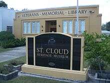
- St. Cloud Heritage Museum
References in popular media
Play (and film) based in St. Cloud
- Sweet Bird of Youth (1959), by Tennessee Williams
Films shot in St. Cloud
- Two Thousand Maniacs! (1964), directed by Herschell Gordon Lewis, starring Connie Mason, William Kerwin and Jeffrey Allen
- The Waterboy (1998), starring Adam Sandler, Henry Winkler, and Kathy Bates
- Barracuda (1978), starring Wayne Crawford, Jason Evers, William Kerwin
References
- "US Gazetteer files: 2010, 2000, and 1990". United States Census Bureau. 2011-02-12. Retrieved 2011-04-23.
- About St. Cloud, FL. stcloud.org. Retrieved 2015-04-26.
- City Facts - St. Cloud, FL. stcloud.org. Retrieved 2015-04-26.
- "2016 U.S. Gazetteer Files". United States Census Bureau. Retrieved Jul 7, 2017.
- "US Board on Geographic Names". United States Geological Survey. 2007-10-25. Retrieved 2008-01-31.
- "U.S. Census website". United States Census Bureau. Retrieved 2015-04-26.
- "Population and Housing Unit Estimates". Retrieved May 21, 2020.
- "Sharing Tales Of Early Settlers Will Preserve St. Cloud's Past". orlandosentinel.com. Retrieved 9 September 2018.
- Berman Law Group
- http://www.stcloudmainstreetflorida.org/history.html
- Dalles, John, "The Pathbreaking Legacy of Ryan and Roberts", in "Reflections", the journal of the Historical Society of Central Florida, Summer 2009; pages 8 and 9.
- Mapquest accessed March 12, 2008
- "Census of Population and Housing". Census.gov. Retrieved June 4, 2015.
- 2010 general population and housing report for St. Cloud
External links
- St. Cloud official website
- Osceola County Library System
- History of St. Cloud, Florida
- History of the St. Cloud Hotel
Municipalities and communities of Osceola County, Florida, United States | ||
|---|---|---|
| Cities | 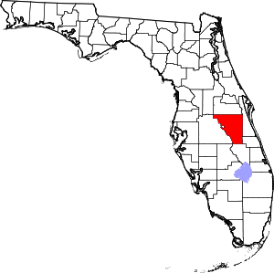 | |
| CDPs | ||
| Unincorporated communities |
| |
| Ghost town | ||
| Footnotes | ‡This populated place also has portions in an adjacent county or counties | |
| Principal cities |  | ||||
|---|---|---|---|---|---|
| Counties |
| ||||
| Populated places | |||||
| Topics | |||||
| Authority control |
|
|---|