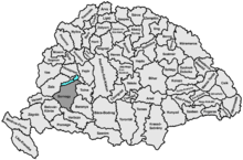
Somogy County (former)
Somogy was an administrative county (comitatus) of the Kingdom of Hungary. Its territory, which was slightly larger than that of present Somogy county, is now in south-western Hungary. The capital of the county was Kaposvár.
| Somogy County | |
|---|---|
| County of the Kingdom of Hungary | |
| 11th century–1946 | |
.svg.png) Coat of arms
| |
 | |
| Capital | Kaposvár |
| Area | |
| • Coordinates | 46°21′N 17°47′E |
• 1910 | 6,675 km2 (2,577 sq mi) |
| Population | |
• 1910 | 365961 |
| History | |
• Established | 11th century |
• Monarchy abolished | 1 February 1946 |
| Today part of | |
Geography
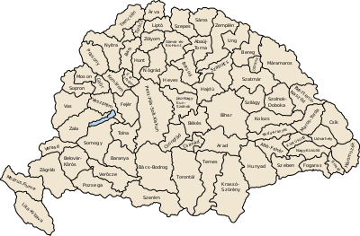
Somogy County shared borders with the Hungarian counties of Zala, Veszprém, Tolna, Baranya, Verőce and Belovár-Körös (the latter two part of Croatia-Slavonia). It extended along the southern shore of Lake Balaton and encompassed the region south of the lake. The river Drava (Hungarian: Dráva) formed most of its southern border. Its area was 6530 km² around 1910.
History
In the 10th century, the Hungarian Nyék tribe occupied the region around Lake Balaton, mainly the areas which are known today as Zala and Somogy counties.[1] Somogy County arose as one of the first comitatus of the Kingdom of Hungary, in the 11th century.
Demographics
1900
In 1900, the county had a population of 345,586 people and was composed of the following linguistic communities:[2]
Total:
- Hungarian: 310,320 (89.8%)
- German: 20,193 (5.8%)
- Croatian: 11,641 (3.4%)
- Romanian: 381 (0.1%)
- Slovak: 291 (0.1%)
- Serbian: 28 (0.0%)
- Ruthenian: 8 (0.0%)
- Other or unknown: 2,724 (0.8%)
According to the census of 1900, the county was composed of the following religious communities:[3]
Total:
- Roman Catholic: 251,246 (72.7%)
- Calvinist: 65,621 (19.0%)
- Lutheran: 17,481 (5.1%)
- Jewish: 10,969 (3.2%)
- Unitarian: 81 (0.0%)
- Greek Catholic: 77 (0.0%)
- Greek Orthodox: 66 (0.0%)
- Other or unknown: 45 (0.0%)
1910
In 1910, the county had a population of 365,961 people and was composed of the following linguistic communities:[4]
Total:
- Hungarian: 333,597 (91.2%)
- German: 18,718 (5.1%)
- Croatian: 9,934 (2.7%)
- Slovak: 364 (0.1%)
- Serbian: 44 (0.0%)
- Romanian: 63 (0.0%)
- Ruthenian: 4 (0.0%)
- Other or unknown: 3,237 (0.9%)
According to the census of 1910, the county was composed of the following religious communities:[5]
Total:
- Roman Catholic: 273,650 (74.8%)
- Calvinist: 63,569 (17.4%)
- Lutheran: 17,700 (4.9%)
- Jewish: 10,645 (2.9%)
- Greek Orthodox: 129 (0.0%)
- Greek Catholic: 106 (0.0%)
- Unitarian: 104 (0.0%)
- Other or unknown: 58 (0.0%)
The city of Siófok, which used to be in Somogy county before the 1850s, went back from Veszprém county to Somogy county before World War II. After World War II, the district of Szigetvár went to Baranya county.
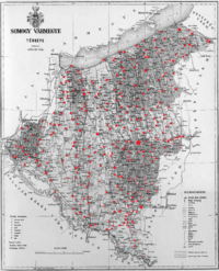
Subdivisions
In the early 20th century, the subdivisions of Somogy county were:
| Districts (járás) | |
|---|---|
| District | Capital (székhely) |
| Barcs | Barcs |
| Csurgó | Csurgó |
| Igal | Igal |
| Kaposvár | Kaposvár |
| Lengyeltóti | Lengyeltóti |
| Marcali | Marcali |
| Nagyatád | Nagyatád |
| Szigetvár | Szigetvár |
| Tab | Tab |
| Urban districts (rendezett tanácsú város) | |
| Kaposvár | |
References
- Béla Kálmán, The world of names: a study in Hungarian onomatology, Akadémiai Kiadó, 1978, p. 134
- "KlimoTheca :: Könyvtár". Kt.lib.pte.hu. Retrieved 26 June 2012.
- "KlimoTheca :: Könyvtár". Kt.lib.pte.hu. Retrieved 26 June 2012.
- "KlimoTheca :: Könyvtár". Kt.lib.pte.hu. Retrieved 26 June 2012.
- "KlimoTheca :: Könyvtár". Kt.lib.pte.hu. Retrieved 26 June 2012.