Csongrád County (former)
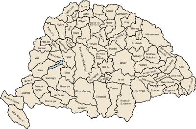
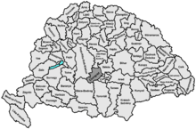
Csongrád (Hungarian: Csongrád, Serbian: Čongrad or Чонград) was an administrative county (comitatus) of the Kingdom of Hungary. Its territory, which was smaller than that of present-day Csongrád county, is now part of Hungary, except a very small area which belongs to Serbia. The capital of the county was Szentes.
| Csongrád County | |
|---|---|
| County of the Kingdom of Hungary | |
| 12th century–1946 | |
.svg.png) Coat of arms
| |
 | |
| Capital | Csongrád; Szeged (1241-1773); Szegvár (1773-1883); Szentes (1883-1946) |
| Area | |
| • Coordinates | 46°39′N 20°16′E |
• 1910 | 3,569 km2 (1,378 sq mi) |
| Population | |
• 1910 | 325568 |
| History | |
• Established | 12th century |
• Treaty of Trianon | 4 June 1920 |
| 11 April 1941 | |
• Monarchy abolished | 1 February 1946 |
| Today part of | (3,462 km2) (107 km2) |
Name
The name Csongrád/Čongrad is Slavic by origin. In Slavic languages, this name means "a black city" (čon/čorni = black, grad = city/town). Indeed, the county was named after a town of Csongrád.
Geography
Csongrád county shared borders with the Hungarian counties Pest-Pilis-Solt-Kiskun, Jász-Nagykun-Szolnok, Békés, Csanád, Torontál and Bács-Bodrog. The river Tisza flowed through the county. Its area was 3,544 km² around 1910.
History
Csongrád county arose in the 11th century as one of the first counties of the Kingdom of Hungary. It was taken by the Ottoman Empire in the 16th century, and reconqered by the Habsburg Kingdom of Hungary at the end of the 17th century.
In 1920, the Treaty of Trianon assigned a small part of the territory of the county - a small area around Horgos (now Horgoš, Vojvodina) in northern Délvidék - to the Kingdom of Serbs, Croats and Slovenes (renamed to Yugoslavia in 1929). The rest remained in Hungary. During Word War II, Hungary annexed the territory lost, but after the end of the war the previous borders were restored.
In 1950, the southern part of Csanád County (which contained then the Hungarian part of the pre-1920 Torontál County and the south-western part of the pre-1920 Csanád County) was added to Csongrád county.
Demographics
1900
In 1900, the county had a population of 296,111 people and was composed of the following linguistic communities:[1]
Total:
- Hungarian: 290,137 (98,0%)
- German: 3,582 (1,2%)
- Serbian: 889 (0,3%)
- Slovak: 564 (0,2%)
- Romanian: 423 (0,1%)
- Croatian: 81 (0,0%)
- Ruthenian: 8 (0,0%)
- Other or unknown: 427 (0,1%)
According to the census of 1900, the county was composed of the following religious communities:[2]
Total:
- Roman Catholic: 216,777 (73,2%)
- Calvinist: 61,315 (20,7%)
- Jewish: 9,537 (3,2%)
- Lutheran: 4,838 (1,6%)
- Greek Orthodox: 2,068 (0,7%)
- Greek Catholic: 603 (0,2%)
- Unitarian: 484 (0,2%)
- Other or unknown: 489 (0,2%)
1910

In 1910, the county had a population of 325,568 people and was composed of the following linguistic communities:[3]
Total:
- Hungarian: 319,274 (98,1%)
- German: 2,862 (0,9%)
- Serbian: 1,235 (0,4%)
- Romanian: 773 (0,2%)
- Slovak: 646 (0,2%)
- Croatian: 94 (0,0%)
- Ruthenian: 11 (0,0%)
- Other or unknown: 673 (0,2%)
According to the census of 1910, the county was composed of the following religious communities:[4]
Total:
- Roman Catholic: 243,343 (74,7%)
- Calvinist: 61,832 (19,0%)
- Jewish: 10,296 (3,2%)
- Lutheran: 5,449 (1,7%)
- Greek Orthodox: 2,828 (0,9%)
- Greek Catholic: 857 (0,3%)
- Unitarian: 547 (0,1%)
- Other or unknown: 416 (0,1%)
Subdivisions
In the early 20th century, the subdivisions of Csongrád county were:

| Districts (járás) | |
|---|---|
| District | Capital |
| Csongrád | Csongrád |
| Tiszáninnen | Kiskundorozsma |
| Tiszántúl | Mindszent |
| Urban counties (törvényhatósági jogú város) | |
| Hódmezővásárhely | |
| Szeged | |
| Urban districts (rendezett tanácsú város) | |
| Szentes | |
_45.jpg)
References
- "KlimoTheca :: Könyvtár". Kt.lib.pte.hu. Retrieved 2012-06-25.
- "KlimoTheca :: Könyvtár". Kt.lib.pte.hu. Retrieved 2012-06-25.
- "KlimoTheca :: Könyvtár". Kt.lib.pte.hu. Retrieved 2012-06-25.
- "KlimoTheca :: Könyvtár". Kt.lib.pte.hu. Retrieved 2012-06-25.