Hunyad County
Hunyad (today mainly Hunedoara) was an administrative county (comitatus) of the Kingdom of Hungary, of the Eastern Hungarian Kingdom and of the Principality of Transylvania. Its territory is now in Romania in Transylvania. The capital of the county was Déva (present-day Deva).
| Hunyad County | |
|---|---|
| County of the Kingdom of Hungary (1265–1526) County of the Eastern Hungarian Kingdom (1526–1570) County of the Principality of Transylvania (1570–1867) County of the Kingdom of Hungary (1867–1920) | |
.svg.png) Coat of arms
| |
| Capital | Déva |
| Area | |
| • Coordinates | 45°53′N 22°54′E |
• 1910 | 7,809 km2 (3,015 sq mi) |
| Population | |
• 1910 | 340100 |
| History | |
• Established | 1265 |
• Treaty of Trianon | 4 June 1920 |
| Today part of | |
| Deva is the current name of the capital. | |
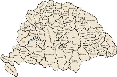
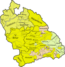
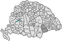
Geography
After 1876, Hunyad county shared borders with Romania and the Hungarian counties Krassó-Szörény, Arad, Torda-Aranyos, Alsó-Fehér and Szeben. Its area was 7809 km² around 1910.
History

Hunyad county was formed in the Middle Ages. It was first attested in 1265 as Hungnod by the Papal Quitrent Register. In 1876, when the administrative structure of Transylvania was changed, its territory was modified. In 1920, by the Treaty of Trianon the county became part of Romania. Most of its territory lies in the present Romanian county Hunedoara; a strip in the east is now part of Alba; a strip in the west is now part of Caraș-Severin County (the commune Băuţar).
Demographics
In 1900, the county had a population of 303,838 people and was composed of the following linguistic communities:[1]
Total:
- Romanian: 257,013 (84.6%)
- Hungarian: 32,316 (10.6%)
- German: 9,189 (3.0%)
- Ruthenian: 697 (0.2%)
- Slovak: 611 (0.2%)
- Croatian: 111 (0.0%)
- Serbian: 56 (0.0%)
- Other or unknown: 3,845 (1.3%)
According to the census of 1900, the county was composed of the following religious communities:[2]
Total:
- Eastern Orthodox: 204,350 (67.3%)
- Greek Catholic: 55,116 (18.1%)
- Roman Catholic: 24,993 (8.2%)
- Calvinist: 11,398 (3.8%)
- Jewish: 4,056 (1.3%)
- Lutheran: 3,269 (1.1%)
- Unitarian: 632 (0.2%)
- Other or unknown: 24 (0.0%)

In 1910, county had a population of 340,135 people and was composed of the following linguistic communities:[1]
Total:
- Romanian: 271,675 (79.9%)
- Hungarian: 52,720 (15.5%)
- German: 8,101 (2.4%)
- Slovak: 1,024 (0.3%)
- Ruthenian: 606 (0.2%)
- Croatian: 195 (0.0%)
- Serbian: 140 (0.0%)
- Other or unknown: 5,674 (1.7%)
According to the census of 1910, the county was composed of the following religious communities:[2]
Total:
- Eastern Orthodox: 217,425 (63.9%)
- Greek Catholic: 60,024 (17.6%)
- Roman Catholic: 34,668 (10.2%)
- Calvinist: 16,675 (4.9%)
- Jewish: 5,679 (1.7%)
- Lutheran: 4,110 (1.2%)
- Unitarianist: 1,525 (0.4%)
- Other or unknown: 29 (0.0%)
Subdivisions
In the early 20th century, the subdivisions of Hunyad County were:
| Districts (járás) | |
|---|---|
| District | Capital |
| Algyógy | Algyógyalfalu, RO Geoagiu |
| Brád | Brád, RO Brad |
| Déva | Déva, RO Deva |
| Hátszeg | Hátszeg, RO Hațeg |
| Kőrösbánya | Kőrösbánya, RO Baia de Criș |
| Marosillye | Marosillye, RO Ilia |
| Petrozsény | Petrozsény, RO Petroșani |
| Puj | Puj, RO Pui |
| Szászváros | Szászváros, RO Orăștie |
| Vajdahunyad | Vajdahunyad, RO Hunedoara |
| Urban districts (rendezett tanácsú város) | |
| Déva, RO Deva | |
| Hátszeg, RO Hațeg | |
| Szászváros, RO Orăștie | |
| Vajdahunyad, RO Hunedoara | |
References
- "KlimoTheca :: Könyvtár". Kt.lib.pte.hu. p. 23. Retrieved 6 December 2012.
- "KlimoTheca :: Könyvtár". Kt.lib.pte.hu. p. 31. Retrieved 6 December 2012.