Zala County
Zala (Hungarian: Zala megye, pronounced [ˈzɒlɒ]; Croatian: Zalska županija; županija Zala) is an administrative county (comitatus or megye) in south-western Hungary. It is named after the Zala River. It shares borders with Croatia and Slovenia and the Hungarian counties Vas, Veszprém and Somogy. The capital of Zala county is Zalaegerszeg. Its area is 3,784 square kilometres (1,461 sq mi). Lake Balaton lies partly in the county.
Zala County Zala megye | |
|---|---|
   | |
 Flag .svg.png) Coat of arms | |
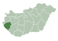 Zala County within Hungary | |
| Country | |
| Region | Western Transdanubia |
| County seat | Zalaegerszeg |
| Districts | |
| Government | |
| • President of the General Assembly | Dr. Attila Pál (Fidesz-KDNP) |
| Area | |
| • Total | 3,783.89 km2 (1,460.97 sq mi) |
| Area rank | 14th in Hungary |
| Population (2015) | |
| • Total | 277,290[1] |
| • Rank | 16th in Hungary |
| Postal code | 8353 – 839x, 874x – 879x, 880x – 883x, 8855, 8856, 886x – 889x, 89xx |
| Area code(s) | (+36) 83, 92, 93 |
| ISO 3166 code | HU-ZA |
| Website | www |
History
In the 10th century, the Hungarian Nyék tribe occupied the region around Lake Balaton. Their occupation was mainly in the areas known today as Zala and Somogy counties.[2]
Parts of the western territory of the former county of Zala are now part of Slovenia (South-Prekmurje). In 1919 it was part of the unrecognized state of the Republic of Prekmurje, which existed for just six days.
Demographics
Religion in Zala County (2011 census)
In 2015, it had a population of 277,290 and the population density was 73/km².
| Year | County population[3] | Change |
|---|---|---|
| 1949 | 305,433 | n/a |
| 1960 | 3.83% | |
| 1970 | -4.10% | |
| 1980 | 4.33% | |
| 1990 | -3.44% | |
| 2001 | -2.94% | |
| 2011 | -5.12% |
Ethnicity
Besides the Hungarian majority, the main minorities are the Roma (approx. 7,000), Croats (3,500) and Germans (2,000).
Total population (2011 census): 282,179
Ethnic groups (2011 census):[4]
Identified themselves: 255 069 persons:
- Hungarians: 241 408 (94,64%)
- Gypsies: 6 981 (2,74%)
- Croats: 3 248 (1,27%)
- Others and indefinable: 3 432 (1,35%)
Approx. 38,000 persons in Zala County did not declare their ethnic group at the 2011 census.
Religion
Religious adherence in the county according to 2011 census:[5]
- Catholic – 177,072 (Roman Catholic – 176,721; Greek Catholic – 313);
- Reformed – 7,000;
- Evangelical – 3,928;
- other religions – 2,463;
- Non-religious – 23,119;
- Atheism – 2,272;
- Undeclared – 66,325.
Regional structure
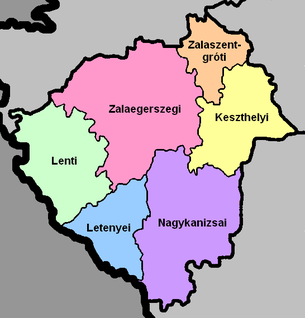
| № | English and Hungarian names |
Area (km²) |
Population (2011) |
Density (pop./km²) |
Seat | № of municipalities |
| 1 | Keszthely District Keszthelyi járás |
535.93 | 49,421 | 92 | Keszthely | 30 |
| 2 | Lenti District Lenti járás |
624.12 | 19,789 | 32 | Lenti | 48 |
| 3 | Letenye District Letenyei járás |
388.69 | 16,410 | 42 | Letenye | 27 |
| 4 | Nagykanizsa District Nagykanizsai járás |
907.91 | 78,252 | 86 | Nagykanizsa | 49 |
| 5 | Zalaegerszeg District Zalaegerszegi járás |
1,044.70 | 102,798 | 98 | Zalaegerszeg | 84 |
| 6 | Zalaszentgrót District Zalaszentgróti járás |
282.56 | 15,509 | 55 | Zalaszentgrót | 20 |
| Zala County | 3,784.11 | 287,043 | 77 | Zalaegerszeg | 258 | |
|---|---|---|---|---|---|---|
Politics
The Zala County Council, elected at the 2014 local government elections, is made up of 15 counselors, with the following party composition:[6]
| Party | Seats | Current County Assembly | |||||||||
|---|---|---|---|---|---|---|---|---|---|---|---|
| Fidesz-KDNP | 9 | ||||||||||
| Movement for a Better Hungary (Jobbik) | 4 | ||||||||||
| Democratic Coalition (DK) | 1 | ||||||||||
| Hungarian Socialist Party (MSZP) | 1 | ||||||||||
Municipalities
Zala County has 2 urban counties, 8 towns, 2 large villages and 246 villages.
- City with county rights
(ordered by population, as of 2011 census)


- Towns
- Villages
- Alibánfa
- Almásháza
- Alsónemesapáti
- Alsópáhok
- Alsórajk
- Alsószenterzsébet
- Babosdöbréte
- Baglad
- Bagod
- Bak
- Baktüttös
- Balatongyörök
- Balatonmagyaród
- Bánokszentgyörgy
- Barlahida
- Batyk
- Bázakerettye
- Becsehely
- Becsvölgye
- Belezna
- Belsősárd
- Bezeréd
- Bocfölde
- Bocska
- Boncodfölde
- Borsfa
- Bókaháza
- Böde
- Bödeháza
- Börzönce
- Búcsúszentlászló
- Bucsuta
- Csapi
- Csatár
- Cserszegtomaj
- Csertalakos
- Csesztreg
- Csonkahegyhát
- Csöde
- Csömödér
- Csörnyeföld
- Dióskál
- Dobri
- Dobronhegy
- Döbröce
- Dötk
- Egeraracsa
- Egervár
- Eszteregnye
- Esztergályhorváti
- Felsőpáhok
- Felsőrajk
- Felsőszenterzsébet
- Fityeház
- Fűzvölgy
- Galambok
- Garabonc
- Gáborjánháza
- Gellénháza
- Gelse
- Gelsesziget
- Gétye
- Gombosszeg
- Gosztola
- Gősfa
- Gutorfölde
- Gyenesdiás

- Gyűrűs
- Hagyárosbörönd
- Hahót
- Hernyék
- Homokkomárom
- Hosszúvölgy
- Hottó
- Iborfia
- Iklódbördőce
- Kacorlak
- Kallósd
- Karmacs
- Kálócfa
- Kányavár
- Kávás
- Kehidakustány
- Kemendollár
- Keménfa
- Kerecseny
- Kerkabarabás
- Kerkafalva
- Kerkakutas
- Kerkaszentkirály
- Kerkateskánd
- Kilimán
- Kisbucsa
- Kiscsehi
- Kisgörbő
- Kiskutas
- Kispáli
- Kisrécse
- Kissziget
- Kistolmács
- Kisvásárhely
- Kozmadombja
- Kustánszeg
- Külsősárd
- Lakhegy
- Lasztonya
- Lendvadedes
- Lendvajakabfa
- Lickóvadamos
- Ligetfalva
- Lispeszentadorján
- Liszó
- Lovászi
- Magyarföld
- Magyarszentmiklós
- Magyarszerdahely
- Maróc
- Márokföld
- Miháld
- Mihályfa
- Mikekarácsonyfa
- Milejszeg
- Misefa
- Molnári
- Murakeresztúr
- Murarátka
- Muraszemenye
- Nagybakónak
- Nagygörbő
- Nagykapornak
- Nagykutas
- Nagylengyel
- Nagypáli
- Nagyrada
- Nagyrécse
- Nemesapáti
- Nemesbük
- Nemeshetés
- Nemesnép
- Nemespátró
- Nemesrádó
- Nemessándorháza
- Nemesszentandrás
- Németfalu
- Nova
- Oltárc
- Orbányosfa
- Ormándlak
- Orosztony
- Ortaháza
- Ozmánbük
- Óhíd
- Padár
- Pakod
- Pat
- Páka
- Pálfiszeg
- Pethőhenye
- Petrikeresztúr
- Petrivente
- Pókaszepetk
- Pórszombat
- Pölöske
- Pölöskefő
- Pördefölde
- Pötréte
- Pusztaapáti
- Pusztaederics
- Pusztamagyaród
- Pusztaszentlászló
- Ramocsa
- Resznek
- Rezi
- Rédics
- Rigyác
- Salomvár
- Sand
- Sárhida
- Sármellék
- Semjénháza
- Sénye
- Sormás
- Söjtör
- Sümegcsehi
- Surd
- Szalapa
- Szécsisziget
- Szentgyörgyvár
- Szentgyörgyvölgy
- Szentkozmadombja
- Szentliszló
- Szentmargitfalva
- Szentpéterfölde
- Szentpéterúr
- Szepetnek
- Szijártóháza
- Szilvágy
- Teskánd
- Tilaj
- Tófej
- Tormafölde
- Tornyiszentmiklós
- Tótszentmárton
- Tótszerdahely
- Türje
- Újudvar
- Valkonya
- Vasboldogasszony
- Vaspör
- Vállus
- Várfölde
- Várvölgy
- Vindornyafok
- Vindornyalak
- Vindornyaszőlős
- Vonyarcvashegy
- Vöckönd
- Zajk
- Zalaapáti
- Zalabaksa
- Zalabér
- Zalaboldogfa
- Zalacsány
- Zalacséb
- Zalaháshágy
- Zalaigrice
- Zalaistvánd
- Zalakomár
- Zalaköveskút
- Zalamerenye
- Zalasárszeg
- Zalaszabar
- Zalaszántó
- Zalaszentbalázs
- Zalaszentgyörgy
- Zalaszentiván
- Zalaszentjakab
- Zalaszentlászló
- Zalaszentlőrinc
- Zalaszentmárton
- Zalaszentmihály
- Zalaszombatfa
- Zalatárnok
- Zalaújlak
- Zalavár
- Zalavég
- Zebecke
![]()
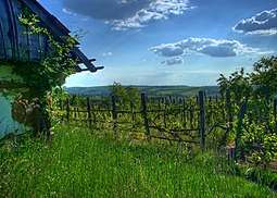
Gallery
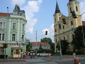
_5.jpg) Zalaegerszeg, the capital of the county
Zalaegerszeg, the capital of the county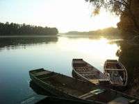 River Drava near Drávaszabolcs
_24.jpg)
 Hévíz, the largest thermal lake in Europe
 Batthyány Palace in Zalaszentgrót
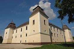 Castle of Egervár
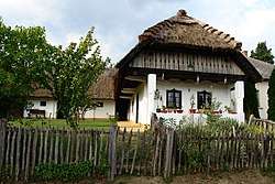 Traditional Hungarian house in Zalalövő
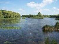
References
| Wikimedia Commons has media related to Zala County. |
| Wikivoyage has a travel guide for Zala County. |
- nepesseg.com, population data of Hungarian settlements
- Béla Kálmán, The world of names: a study in Hungarian onomatology, Akadémiai Kiadó, 1978, p. 134
- népesség.com, "Győr-Moson-Sopron megye népessége 1870-2015"
- 1.1.6. A népesség anyanyelv, nemzetiség és nemek szerint – Frissítve: 2013.04.17.; Hungarian Central Statistical Office (in Hungarian)
- 2011. ÉVI NÉPSZÁMLÁLÁS, 3. Területi adatok, 3.20 Zala megye, (in Hungarian)
- Zala Megyei Közgyűlés, (in Hungarian)
- Önkormányzati választások eredményei (in Hungarian)
External links
- Official site in Hungarian and German
- Zalai Hírlap (zaol.hu) - The county portal
| Authority control |
|
|---|