Csanád County
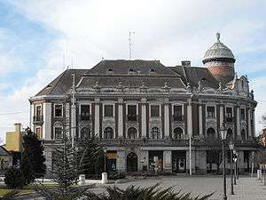
Csanád was an administrative county (comitatus) of the Kingdom of Hungary. Its territory is now part of Hungary, except a small area which is part of Romania. The capital of the county was Makó.
| Csanád County | |
|---|---|
| County of the Kingdom of Hungary (11th century-1542) County of the Eastern Hungarian Kingdom (1542-1552) County of the Kingdom of Hungary (1716-1853, 1860-1923, 1945-1946) County of the Second Hungarian Republic (1946-1949) County of the Hungarian People's Republic (1949-1950) | |
.svg.png) Coat of arms
| |
 | |
| Capital | Marosvár (Csanád 1028-) ;Makó (1730-1950) |
| Area | |
| • Coordinates | 46°13′N 20°29′E |
• 1910 | 1,714 km2 (662 sq mi) |
| Population | |
• 1910 | 145200 |
| History | |
• Established | 11th century |
• Ottoman conquest | 1552 |
• County recreated | 1716 |
• Merged into Békés-Csanád County | 1853 |
• County recreated | 20 October 1860 |
• Treaty of Trianon | 4 June 1920 |
• Merged into Csanád-Arad-Torontál County | 1923 |
• County recreated | 1945 |
• Disestablished | 16 March 1950 |
| Today part of | (1,469 km2) (245 km2) |
| Cenad is the current name of the capital. | |
Geography
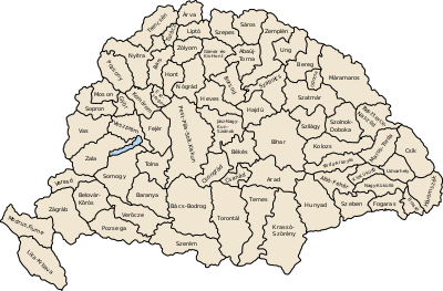
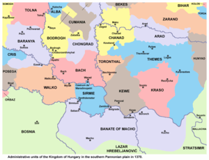
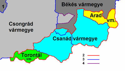
Csanád county shared borders with the Hungarian counties Csongrád, Békés, Arad and Torontál. The river Maros (now Mureş) formed its southern border. Its area was 1714 km2 around 1910.
History
The county's territory became part of the Kingdom of Hungary in the first half of the 11th century when Stephen I of Hungary defeated Ajtony, local ruler. The county got its name after the commander of the royal army, Csanád. The king appointed Gerard of Csanád first bishop of Csanád. The county was initially much larger, it included territories of the later Temes, Arad, and Torontál counties. The first seat of the county was Csanád (present-day Cenad, Romania).
The county's territory became part of the Ottoman Empire in the 16th century. The settlement structure was almost completely destroyed during the Ottoman-Habsburg wars. In the Treaty of Karlowitz, the Ottoman Empire renounced its claims to the territories north of the Maros (Mureș) river. Csanád county was reorganized in the returned territories (with greatly reduced territory). Makó became the seat of the reorganized county.
After World War I, the county was occupied by the Romanian army. In 1920, the Treaty of Trianon assigned a small area in the southeast of the county (Nădlac and Șeitin) to Romania. The rest of the county was united with parts of Torontál county (a small area south of Szeged) and Arad county (a small area south of Békéscsaba) to form the new county of Csanád-Arad-Torontál in 1923.
After World War II, the county was recreated, but in 1950 the county was divided between the Hungarian counties of Békés and Csongrád. The Romanian part of former Csanád county is now part of the Romanian county of Arad.
Demographics
Csanád county was one of the most densely populated counties of the Hungarian Kingdom. The Hungarians formed an ethnic majority in every district except for the district Nagylak. The main part of the Slovaks and Romanians lived in the district Nagylak, the Serbs in the district Battonya.
1900
In 1900, the county had a population of 140,007 people and was composed of the following linguistic communities:[1]
Total:
- Hungarian: 103,242 (73,8%)
- Slovak: 17,274 (12,3%)
- Romanian: 13,982 (10,0%)
- Serbian: 3,981 (2,8%)
- German: 1,182 (0,8%)
- Ruthenian: 72 (0,1%)
- Croatian: 1 (0,0%)
- Other or unknown: 273 (0,2%)
According to the census of 1900, the county was composed of the following religious communities:[2]
Total:
- Roman Catholic: 71,610 (51,3%)
- Calvinist: 25,234 (18,0%)
- Lutheran: 18,384 (13,1%)
- Greek Orthodox: 16,567 (11,8%)
- Greek Catholic: 4,520 (3,2%)
- Jewish: 3,254 (2,3%)
- Unitarian: 33 (0,0%)
- Other or unknown: 405 (0,3%)
1910

In 1910, the county had a population of 145,249 people and was composed of the following linguistic communities:[3]
Total:
- Hungarian: 108,621 (74,8%)
- Slovak: 17,133 (11,8%)
- Romanian: 14,046 (9,7%)
- Serbian: 3,967 (2,7%)
- German: 1,013 (0,7%)
- Ruthenian: 119 (0,1%)
- Croatian: 8 (0,0%)
- Other or unknown: 341 (0,2%)
According to the census of 1910, the county was composed of the following religious communities:[4]
Total:
- Roman Catholic: 76,076 (52,4%)
- Calvinist: 24,897 (17,1%)
- Lutheran: 19,095 (13,1%)
- Greek Orthodox: 16,851 (11,6%)
- Greek Catholic: 4,438 (3,1%)
- Jewish: 3,353 (2,3%)
- Unitarian: 118 (0,1%)
- Other or unknown: 421 (0,3%)
Subdivisions
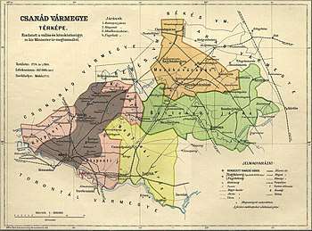
In the early 20th century, the subdivisions of Csanád county were:
| Districts (járás) | |
|---|---|
| District | Capital |
| Battonya | Battonya |
| Központ | Makó |
| Mezőkovácsháza | Mezőkovácsháza |
| Nagylak | Nagylak (Romanian: Nădlac) |
| Urban districts (rendezett tanácsú város) | |
| Makó | |
The town of Nădlac is now in Romania; the other towns mentioned are now in Hungary.
References
- "KlimoTheca :: Könyvtár". Kt.lib.pte.hu. Retrieved 2012-06-25.
- "KlimoTheca :: Könyvtár". Kt.lib.pte.hu. Retrieved 2012-06-25.
- "KlimoTheca :: Könyvtár". Kt.lib.pte.hu. Retrieved 2012-06-25.
- "KlimoTheca :: Könyvtár". Kt.lib.pte.hu. Retrieved 2012-06-25.