Kolozs County
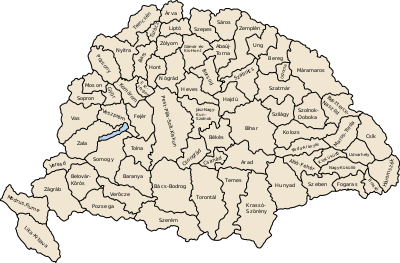
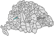
Kolozs County was an administrative county (comitatus) of the Kingdom of Hungary, of the Eastern Hungarian Kingdom and of the Principality of Transylvania. Its territory is now in north-western Romania (north-western Transylvania). The capital of the county was Kolozsvár (present-day Cluj-Napoca).
| Kolozs County | |
|---|---|
| County of the Kingdom of Hungary (11th century-1526) County of the Eastern Hungarian Kingdom (1526-1570) County of the Principality of Transylvania (1570-1867) County of the Kingdom of Hungary (1867-1920, 1940-1945) | |
.svg.png) Coat of arms
| |
 | |
| Capital | Kolozsvár |
| Area | |
| • Coordinates | 46°46′N 23°36′E |
• 1910 | 5,006 km2 (1,933 sq mi) |
| Population | |
• 1910 | 286700 |
| History | |
• Established | 11th century |
• Treaty of Trianon | 4 June 1920 |
• County recreated (Second Vienna Award) | 30 August 1940 |
• Disestablished | 1945 |
| Today part of | |
| Cluj-Napoca is the current name of the capital. | |
Geography
After 1876, Kolozs county shared borders with the Hungarian counties Bihar, Szilágy, Szolnok-Doboka, Beszterce-Naszód, Maros-Torda and Torda-Aranyos. The rivers Sebes-Körös and Kis-Szamos flowed through the county. Its area was 5006 km² in 1910.
History
Kolozs county was formed in the 11th century. In 1920, by the Treaty of Trianon the county became part of Romania. Following the Second Vienna Award, large part of tt was retaken by Hungary in 1940 and the county was recreated, however, after World War II it became part of Romania again. Most of the territory of the county lies in the present Romanian county Cluj, some parts of the county are in the present Romanian counties Sălaj (north-west), Bistrița-Năsăud (north-east) and Mureș (south-east).
Demographics
In 1900, the county had a population of 212,352 people and was composed of the following linguistic communities:[1]
Total:
- Romanian: 146,268 (57.7%)
- Hungarian: 95,626 (37.7%)
- German: 9,058 (3.6%)
- Slovak: 170 (0.0%)
- Croatian: 33 (0.0%)
- Serbian: 22 (0.0%)
- Ruthenian: 9 (0.0%)
- Other or unknown: 2,470 (1.0%)
According to the census of 1900, the county was composed of the following religious communities:[2]
Total:
- Greek Catholic: 113,136 (44.6%)
- Calvinist: 58,297 (23.0%)
- Eastern Orthodox: 36,578 (14.4%)
- Roman Catholic: 24,821 (9.8%)
- Jewish: 9,858 (3.9%)
- Lutheran: 7,864 (3.1%)
- Unitarian: 3,020 (1.2%)
- Other or unknown: 82 (0.0%)

In 1910, county had a population of 286,687 people and was composed of the following linguistic communities:[3]
Total:
- Romanian: 161,279 (56.3%)
- Hungarian: 111,439 (38.9%)
- German: 8,386 (2.9%)
- Slovak: 169 (0.0%)
- Croatian: 55 (0.0%)
- Serbian: 44 (0.0%)
- Ruthenian: 13 (0.0%)
- Other or unknown: 5,302 (1.9%)
According to the census of 1910, the county was composed of the following religious communities:[4]
Total:
- Greek Catholic: 126,217 (44.0%)
- Calvinist: 65,910 (23.0%)
- Eastern Orthodox: 41,715 (14.6%)
- Roman Catholic: 28,427 (9.9%)
- Jewish: 12,581 (4.4%)
- Lutheran: 8,167 (2.9%)
- Unitarianist: 3,331 (1.2%)
- Other or unknown: 339 (0.0%)
Subdivisions
In the early 20th century, the subdivisions of Kolozs county were:
| Districts (járás) | |
|---|---|
| District | Capital |
| Bánffyhunyad | Bánffyhunyad, RO Huedin |
| Gyalu | Gyalu, RO Gilău |
| Hídalmás | Hídalmás, RO Hida |
| Kolozsvár | Kolozsvár, RO Cluj |
| Mezőörményes | Mezőörményes, RO Urmeniș |
| Mocs | Mocs, RO Mociu |
| Nádasment | Kolozsvár, RO Cluj |
| Nagysármás | Nagysármás, RO Sărmașu |
| Teke | Teke, RO Teaca |
| Urban counties (törvényhatósági jogú város) | |
| Kolozsvár, RO Cluj | |
| Urban districts (rendezett tanácsú város) | |
| Kolozs, RO Cojocna | |
References
- "KlimoTheca :: Könyvtár". Kt.lib.pte.hu. Retrieved 6 December 2012.
- "KlimoTheca :: Könyvtár". Kt.lib.pte.hu. Retrieved 6 December 2012.
- "KlimoTheca :: Könyvtár". Kt.lib.pte.hu. Retrieved 19 June 2012.
- "KlimoTheca :: Könyvtár". Kt.lib.pte.hu. Retrieved 19 June 2012.