Hunza (princely state)
Hunza (Urdu: ہنزہ), also known as Kanjut, was a princely state in a subsidiary alliance with British India from 1892 to August 1947, for three months was unaligned, and then from November 1947 until 1974 was a princely state of Pakistan. Hunza covered territory now forming the northernmost part of Gilgit-Baltistan, Pakistan.[1]
| Hunza ہنزہ | |||||||
|---|---|---|---|---|---|---|---|
| Princely State of British India | |||||||
| 1500s–1974 | |||||||
 Flag | |||||||
| Area | |||||||
• 1500s | 10,101 km2 (3,900 sq mi) | ||||||
| History | |||||||
• Established | 1500s | ||||||
• Disestablished | 24 September 1974 | ||||||
| |||||||
| Today part of | Gilgit-Baltistan, Pakistan | ||||||
| Northern Areas Government | |||||||
 |
| This article is part of the series |
| Former administrative units of Pakistan |
|---|
|
Original provinces
|
|
One-unit provinces |
|
Other subdivisions |
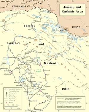
The princely state bordered the Gilgit Agency to the south, the former princely state of Nagar to the east, Xinjiang, China to the northeast and Afghanistan to the northwest. The state capital was Baltit (also known as Karimabad). The princely state of Hunza now is the Aliabad tehsil of Hunza–Nagar District in Pakistan.
History
Hunza was an independent principality for centuries. It was ruled by the Mirs of Hunza, who took the title of Thum.
The Hunzas were tributaries and allies to China, acknowledging China as suzerain since 1761.[2][3] Hunza rulers claimed descent from Alexander the Great, and viewed themselves and the Emperor of China as being the most important leaders in the world.[4] When the Kanjutis (people of Hunza) raided mountainous places of Karakorum and Kunlun mountains, including Xaidulla, where some groups of the nomadic Kirghiz were the main inhabitants, they sold some Kirghiz slaves to the Chinese.[5]
From 1847 the Mir of Hunza gave nominal allegiance to China. This resulted from assistance given by Mir Ghazanfur Khan to China in fighting against the Uyghur separatist Afaqi Khoja revolts in Yarkand, following which China granted Hunza a jagir (Land grant) in Yarkand and paid the Mir a subsidy.[6][7] The last fully independent ruler, Mir Safdar Khan, who ruled from 1886, escaped to China after an invasion by the British.[4]
In the late 19th century Hunza became embroiled in the Great Game, the rivalry between Britain and Russia for control of the northern approaches to India. The British suspected Russian involvement "with the Rulers of the petty States on the northern boundary of Kashmir";[8] In 1888 the Russian Captain Bronislav Grombchevsky visited Hunza,[9] and the following year the British Captain Francis Younghusband visited Hunza to express British displeasure at Kanjuti raids in the Raskam. Younghusband formed a low opinion of the ruler, Safdar Ali, describing him as "a cur at heart and unworthy of ruling so fine a race as the people of Hunza".[10] In 1891 the British mounted the Hunza-Nagar Campaign and gained control of Hunza and the neighbouring valley of Nagar. The Mir, Safdar Khan, fled to China and his younger brother Mir Mohammad Nazim Khan was installed by the British as Mir in September 1892.[11] Hunza became a princely state in a subsidiary alliance with British India, a status it retained until 1947. The Kuomintang Republic of China government engaged in secret negotiations with the Mir of Hunza over restoring the state's previous relations with China, amidst the partitioning of British India, with the Hunza state independent from India and Pakistan. The Kuomintang also plotted to expand its influence into Kashmir, taking advantage of the weakness of the newly independent India. However, due to the war of 1947 that erupted between Pakistan and India over their dispute in Kashmir, the Mir of Hunza changed his mind and acceded to Pakistan, after a coup against India in Gilgit.[12]
Territorial claims
Historically the people of Hunza cultivated and grazed areas to the north, and the Mir claimed those areas as part of Hunza's territories. Those areas included the Taghdumbash Pamir and the Raskam Valley.[13]
According to Kanjuti traditions, as related by McMahon, the Mir’s eighth ancestor, Shah Salim Khan, pursued nomadic Khirghiz thieves to Tashkurghan and defeated them. "To celebrate this victory, Shah Salim Khan erected a stone cairn at Dafdar and sent a trophy of a Khirghiz head to the Chinese with a message that Hunza territory extended as far as Dafdar". The Kanjutis were already in effective possession of the Raskam and no question had been raised about it. The Mir’s claims went a good deal beyond a mere right of cultivation. He "asserts that forts were built by the Hunza people without any objection or interference from the Chinese at Dafdar, Qurghan, Ujadhbhai, Azar on the Yarkand River and at three or four other places in Raskam."[14]
McMahon was able roughly to define the territorial limits of Kanjut. "The boundaries of Taghdumbash, Khunjerab, and Raskam, as claimed by the Kanjuts, are the following: the northern watershed of the Taghdumbash Pamir from the Wakhjir Pass through the Baiyik peak to Dafdar, thence across the river to the Zankan nullah; thence through Mazar and over the range to Urok, a point on the Yarkand river between Sibjaida and Itakturuk. Thence it runs along the northern watershed of the Raskam valley to the junction of the Bazar Dara River and the Yarkand River. From thence southwards over the mountains to the Mustagh River leaving the Aghil Dewan or Aghil Pass within Hunza limits."[15]
McMahon’s information was substantially corroborated in 1898 by Captain H. P. P. Deasy, who resigned his commission to devote himself to trans-Himalayan exploration. An item of special interest was Deasy’s description of the limits of Raskam. Starting from Aghil Dewan or pass, in the Karakoram range, the dividing line ran north-east to Bazar Dara, where it met the Yarkand River. He found an outpost built of earth at Bazar Dara, surmounted by a Chinese flag (by 1898 the Chinese had intruded to the area south of the Kun Lun Mountains with a few unarmed Kirghiz in occupation. This was obviously intended as a Chinese boundary marker. From there the line ran “along the northern watershed of the Raskam valley to Dafdar in the Taghdumbash Pamir, to the north of the mills at that place, and thence to the Baiyik peak. Deasy also came upon clear evidence of what could only have been Kanjuti occupation. South of Azgar “many ruins of houses, old irrigation channels and fields now no longer tilled, testify to Raskam having formerly been inhabited and cultivated”. Anyone familiar with the care with which the Kanjuts cultivate every available strip of land in their own Hunza would have no hesitation in regarding this as proof of long standing Kanjuti occupation. The remains could not have been attributed to the Kirghiz; they were unfamiliar with the state of art.[16] "Seven locations in the Raskam were involved. Azgar and Ursur on the right bank, and five others on the left, that is on the Mustagh-Karakoram side-Kukbash, Kirajilga, Ophrang, Uroklok, and Oitughrak, extending from Sarakamish, north of Kunjerab pass to Bazar Dara, north of the Arghil pass". He said it was an area of about 3,000 acres (12 km2).
The Chinese completed the reconquest of Xinjiang in 1878. Before they lost southern parts of the province to Yakub Beg in 1863, their practical authority, as Ney Elias and Younghusband consistently maintained, had never extended south of their outposts at Sanju and Kilian along the northern foothills of the Kun Lun range. Nor did they establish a known presence to the south of the line of outposts in the twelve years immediately following their return.[17] Ney Elias, who had been Joint Commissioner in Ladakh for several years, noted on 21 September 1889 that he had met the Chinese in 1879 and 1880 when he visited Kashgar. "They told me that they considered their line of ‘chatze’, or posts, as their frontier – viz., Kugiar, Kilian, Sanju, Kiria, etc.- and that they had no concern with what lay beyond the mountains" i.e. the Kun Lun range in northern Kashmir.[18]
In March 1899 the British proposed, in a Note from Sir Claude MacDonald to China, a new boundary between China and British India. The Note proposed that China should relinquish its claims to suzerainty over Hunza, and in return Hunza should relinquish its claims to most of the Taghdumbash and Raskam districts. The Chinese did not respond to the note.[19]
Until 1937 the inhabitants of the Taghdumbash Pamir paid tribute to the Mir of Hunza, who exercised control over the pastures,[20]
Relationship with Jammu and Kashmir
Although never ruled directly by neighbouring Jammu and Kashmir, Hunza was a vassal of Jammu and Kashmir from the time of Maharaja Ranbir Singh of Jammu and Kashmir (mid-1800s). The Mirs of Hunza never sent an annual tribute to the Jammu and Kashmir Durbar until 1947, and along with the ruler of Nagar were considered to be among the most loyal vassals of the Maharaja of Jammu and Kashmir. According to Emma Nicholson, "All the evidence points to the fact that Gilgit and Baltistan region were constituent parts of Jammu and Kashmir by 1877". They were under the sovereignty of the Maharaja of Jammu and Kashmir and remained in this princely domain till the date of accession "in its entirety to the new Dominion of India" on 26 October 1947.[21] Further, this fact is confirmed and reiterated from the correspondence of the Maharaja of Jammu and Kashmir dated 26 October 1947 with Lord Mountbatten, Governor General of India[22] which states that the state of Jammu and Kashmir has a common boundary with the "Soviet Republic", and the said statement also determines the fact that inter alia Gilgit and Kanjut (which includes the Raskam, Hunza valley and Taghdumbash) are integral parts of Jammu and Kashmir. Pandit Jawaharlal Nehru had also made a similar statement that "Jammu and Kashmir's Northern frontiers, as you are aware, run in common with those of three countries, Afghanistan, the Union of Soviet Socialist Republics and China".[23] These statements of the Maharaja of Jammu and Kashmir as well as Pandit Jawaharlal Nehru also have a bearing on the territorial extent of Kanjut as well as the rest of the princely state of Jammu and Kashmir at the time of her accession "in its entirety to the new Dominion of India" on 26 October and Section (4)[24] of the Constitution of Jammu and Kashmir which pertains to the territorial extent of the Indian state of Jammu and Kashmir also unequivocally states that "The territory of the State shall comprise all the territories which on the fifteenth day of August, 1947, were under the sovereignty or suzerainty of the Ruler of the State".
Accession to Pakistan
On 3 November 1947, the ruler, Mohammad Jamal Khan sent a telegram to Mohammad Ali Jinnah acceding his state to Pakistan.[25] It stated:
"I declare with pleasure on behalf of myself and my State accession to Pakistan."
Government
The state was governed by hereditary rulers who took the title of "Mir" and were assisted by a council of Wazirs or Ministers. Details for early rulers are uncertain, with the first definite dates available from 1750 onwards.
| Reign | Mirs of Hunza[26] | |
|---|---|---|
| Uncertain dates | Salim Khan II | |
| Uncertain dates | Shah Sultan Khan | |
| 1710 - uncertain date | Shahbaz Khan | |
| Uncertain dates | Shahbeg Khan | |
| ~1750 - 1790 | Shah Kisro Khan | |
| 1790 | Mirza Khan | |
| 1790–1825 | Salim Khan III | |
| 1825–1863 | Ghazanfur Khan | |
| 1863–1886 | Mohammad Ghazan Khan I | |
| 1886 - Dec 1891 | Safdar Ali Khan | |
| 15 September 1892 – 22 July 1938 | Mohammad Nazim Khan K.C.I.E | |
| 22 July 1938 - 1945 | Mohammad Ghazan Khan II | |
| ? 1945 - 25 September 1974 | Mohammad Jamal Khan | |
| 25 September 1974 - | Princely State of Hunza was dissolved and declared part of Northern Areas |
Geography
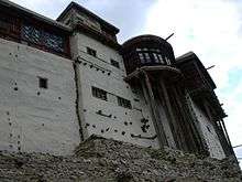
The Hunza valley is situated at an elevation of 2,438 metres (7,999 feet). The former capital Baltit has an elevation of 2477 metres (8129 feet).[27] Both Baltit and an earlier fort, Altit Fort, have been extensively restored and are major tourist attractions in the region.
For many centuries, Hunza has provided the quickest access to Swat and Gandhara for a person travelling on foot. The route was impassable to baggage animals; only human porters could get through, and then only with permission from the locals.
Hunza was easily defended as the paths were often less than half a metre (about 18") wide. The high mountain paths often crossed bare cliff faces on logs wedged into cracks in the cliff, with stones balanced on top. They were also constantly exposed to regular damage from weather and falling rocks. These were the much feared "hanging passageways" of the early Chinese histories that terrified all, including several famous Chinese Buddhist monks.
Demographics
Most of the people of Hunza are Ismaili Muslims. The common language of Hunza is Burushaski, while Wakhi and Shina languages are spoken in Upper Hunza and Lower Hunza respectively. Urdu and English languages are also widely understood in Hunza.
See also
- Hunza Valley
- Hunza District
- Northern Areas
- Karakoram Highway
- Karakoram Mountains
- Nagar
References
- Younghusband, Francis (1904). The Heart of a Continent. p. 186.
- Oriental Institute (Woking, England), East India Association (London, England) (1892). The Imperial and asiatic quarterly review and oriental and colonial record. Oriental Institute. p. 74. Retrieved 23 January 2011.CS1 maint: multiple names: authors list (link)
- The Draft History of Qing, volume 529, Revised Edition, 1977, Zhonghua Book Company.
- Edward Frederick Knight (1893). Where three empires meet: a narrative of recent travel in Kashmir, western Tibet, Gilgit, and the adjoining countries. Longmans, Green, and Co. p. 331. Retrieved 23 January 2011.
- Ralph Patteson Cobbold (1900). Innermost Asia: travel & sport in the Pamirs. Charles Scribner's Sons. p. 22. Retrieved 23 January 2011.
mir of hunza who sold the kirghiz to the chinese as slaves for 120 rupees.
- Woodman, Himalayan Frontiers 1970, pp. 90–.
- John Biddulph (1880). Tribes of the Hindoo Koosh. Office of the superintendent of government printing. pp. 28–.
Ghazanfur 1847.
- Forty-one years in India - From Subaltern To Commander-In-Chief, Lord Roberts of Kandahar - The Hunza-Nagar Campaign
- Younghusband, Francis (1896). The Heart of a Continent. p. 235.
- Hopkirk, The Great Game 2006, p. 461.
- History of The Northern Areas of Pakistan By Prof. A.H. Dani, Islamabad 1991
- Lin, Modern China's Ethnic Frontiers 2010, pp. 111–.
- Lall, Aksaichin and Sino-Indian Conflict 1989.
- For. Sec. F., October 1896, 533/541 (534)
- For. Sec. F.July 1898,306/347 (327)
- For. Sec. F., August 1899, 168/201 (175)
- Lall, Aksaichin and Sino-Indian Conflict 1989, pp. 56-57, 59, 95.
- For. Sec. F. October 1889, 182/197.
- Woodman, Himalayan Frontiers 1970, pp. 74–75, 366.
- Kreutzmann, H. Yak Keeping in Western High Asia
- Emma Nicholson's letter to Ambassdor Khalid Archived 26 March 2009 at the Wayback Machine
- Hari Singh
- Kasnehru
- "Archived copy". Archived from the original on 7 May 2013. Retrieved 16 April 2013.CS1 maint: archived copy as title (link)
- Jinnah Papers The states: Historical and Policy Perspectives and Accession to Pakistan, First series volume VIII, Editor: Z.H.Zaidi, Quaid-i-Azam Papers Project, Government of Pakistan 2003 Pg 113
- Ben Cahoon, WorldStatesmen.org. "Pakistan Princely States". Retrieved 3 October 2007.
- Falling rain - Location of Baltit Archived 22 June 2007 at the Wayback Machine
Bibliography
- Hopkirk, Peter (2006), The Great Game, Hodder & Stoughton, ISBN 978-1-84854-477-2
- Lall, J. S. (1989), Aksaichin and Sino-Indian Conflict, Allied Publishers
- Lin, Hsiao-ting (2010). Modern China's Ethnic Frontiers: A Journey to the West. Taylor & Francis. ISBN 978-0-203-84497-7.
- Mehra, Parshotham (1991), ""John Lall, Aksai Chin and Sino-Indian Conflict" (Book review)", China Report, 27 (2): 147–154, doi:10.1177/000944559102700206
- Noorani, A.G. (2010), India–China Boundary Problem 1846–1947: History and Diplomacy, Oxford University Press India, doi:10.1093/acprof:oso/9780198070689.001.0001, ISBN 978-0-19-908839-3
- Woodman, Dorothy (1970) [first published in 1969 by Barrie & Rockliff, The Cresset Press], Himalayan Frontiers: A Political Review of British, Chinese, Indian, and Russian Rivalries, Praeger