Gêrzê County
Gêrzê County[6][7][8] (Tibetan: སྒེར་རྩེ་རྫོང་།, Wylie: sger rtse rdzong, ZYPY: Gêrzê Zong ; simplified Chinese: 改则县; traditional Chinese: 改則縣; pinyin: Gǎizé Xiàn) is a county located in Ngari Prefecture in the northwest of the Tibet Autonomous Region, bordering Xinjiang to the north.[3]
Gêrzê County སྒེར་རྩེ་རྫོང་། 改则县 Gaize, Kai-tse | |
|---|---|
County | |
 | |
.png) Location of Gêrzê County (red) within Ngari Prefecture (yellow) and the Tibet A.R. (outdated map) | |
 Gêrzê Location of the seat in the Tibet A.R. | |
| Coordinates: 33°45′53″N 84°07′22″E | |
| Country | People's Republic of China |
| Region | Tibet |
| Prefecture | Ngari |
| Established date[1][2][3][4] | October 1960 |
| Seat | Gêrzê Town[3] |
| Township-level divisions[1] | 1 town, 6 townships |
| Area | |
| • Total | 135,025 km2 (52,133 sq mi) |
| Elevation | over 4,500 m (over 14,800 ft) |
| Population (2015)[1] | |
| • Total | 46,930 |
| • Density | 0.35/km2 (0.90/sq mi) |
| Ethnic groups | |
| • Major ethnic groups | Tibetan[4] |
| Time zone | UTC+8 (China Standard) |
| Postal code | 859200 |
| Website | gz |
Name
Gêrzê is the Tibetan word for a special type of local-style dwelling built on the peak of a mountain.[1]
History
The area was originally inhabited by nomadic tribes.[3]
In the aftermath of the Annexation of Tibet by the People's Republic of China in the early 1950s, People's Liberation Army troops were stationed in Gêrzê.[9]
On May 3, 1960, the Gêrzê County Committee of the Communist Party of China was established. On October 1, 1960, the Gêrzê County government was established.[1][2][3][4]
At 2:01 AM on February 21, 2020, a 5.0 magnitude earthquake struck in Gêrzê County (epicenter: 34.56°N 85.68°E).[10]
At 2:12 AM on March 10, 2020, a 5.0 magnitude earthquake struck in Gêrzê County (epicenter: 32.84°N 85.52°E) followed by a 3.7 magnitude and a 3.4 magnitude aftershock. No casualties were reported.[5]
On May 8, 2020, eight suspects were arrested and eighty-nine antelope skins were confiscated in connection with reported Tibetan antelope poaching in the county.[11]
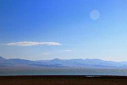
Geography

Gêrzê County is bordered to the north by Keriya County (Yutian) in Hotan Prefecture (Hetian), Xinjiang and to the west by Rutog County.[12] There are numerous lakes in Gêrzê County including Tong Tso. Thermal springs in Gêrzê County include Lugu[7] (70°C; 33°24′24″N 84°08′12″E; altitude 4,528 m (14,856 ft)), Nagezhong (60°C; 32°18′N 84°12′E; altitude 4,550 m (14,930 ft)) and Yarlhaingari (60°C; 33°00′48″N 86°01′36″E; altitude 4,880 m (16,010 ft)).[13]
Climate
Gêrzê County has a cold semi-arid climate (Köppen climate classification: BSk), with strong dry-winter subarctic climate tendencies (Köppen: Dwc).
| Climate data for Gêrzê (1981–2010 normals) | |||||||||||||
|---|---|---|---|---|---|---|---|---|---|---|---|---|---|
| Month | Jan | Feb | Mar | Apr | May | Jun | Jul | Aug | Sep | Oct | Nov | Dec | Year |
| Average high °C (°F) | −2.9 (26.8) |
−0.8 (30.6) |
3.5 (38.3) |
8.1 (46.6) |
12.8 (55.0) |
18.0 (64.4) |
20.1 (68.2) |
18.5 (65.3) |
15.7 (60.3) |
8.1 (46.6) |
2.5 (36.5) |
−1.6 (29.1) |
8.5 (47.3) |
| Daily mean °C (°F) | −11.7 (10.9) |
−8.9 (16.0) |
−4.5 (23.9) |
0.0 (32.0) |
4.7 (40.5) |
10.0 (50.0) |
12.8 (55.0) |
11.6 (52.9) |
8.5 (47.3) |
0.1 (32.2) |
−6.9 (19.6) |
−11.2 (11.8) |
0.4 (32.7) |
| Average low °C (°F) | −21.4 (−6.5) |
−18.6 (−1.5) |
−14.0 (6.8) |
−8.9 (16.0) |
−3.5 (25.7) |
2.1 (35.8) |
6.0 (42.8) |
5.5 (41.9) |
1.5 (34.7) |
−8.1 (17.4) |
−15.9 (3.4) |
−20.7 (−5.3) |
−8.0 (17.6) |
| Average precipitation mm (inches) | 0.8 (0.03) |
0.7 (0.03) |
1.2 (0.05) |
2.3 (0.09) |
7.0 (0.28) |
22.6 (0.89) |
48.2 (1.90) |
59.8 (2.35) |
22.6 (0.89) |
4.8 (0.19) |
0.6 (0.02) |
0.7 (0.03) |
171.3 (6.75) |
| Average relative humidity (%) | 28 | 25 | 25 | 28 | 33 | 38 | 47 | 55 | 44 | 31 | 26 | 28 | 34 |
| Source: China Meteorological Administration[14] | |||||||||||||
Demographics
| Historical population | ||
|---|---|---|
| Year | Pop. | ±% p.a. |
| 2000 | 17,502 | — |
| 2010 | 22,177 | +2.40% |
| [4] | ||
As of 1996, the residents of the county were Tibetan.[4] In 1999, the population of the county was 16,623.[16]
Economy
The main economic activity in Gêrzê County is animal husbandry[5] which includes the raising of yak, dzo, sheep, goats, and horses. The county also has wild yak, wild donkeys, wild sheep, bears and Tibetan antelope.[3]
Transportation
- Hei'agong Road (黑阿公路)[3]
Historical maps
Historical maps including Gêrzê:
 Map of the expeditions of Sven Hedin (1906-8) including the modern-day Gêrzê County area (RGS, early 20th century)
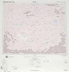 Map including Gêrzê (labeled as Kai-tse) (DMA, 1975)
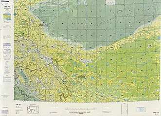 Map including Gêrzê (Kai-tse) (DMA, 1980)
 Map of the Gêrzê area (DMA, 1990)
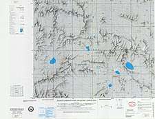


See also
References
- 地区经济司 (30 November 2017). 西藏自治区阿里地区改则县. National Development and Reform Commission (in Chinese). Archived from the original on 25 May 2020. Retrieved 25 May 2020 – via Internet Archive.
改则县隶属阿里地区,全县总面积135025平方公里,辖1镇6乡。2015年总人口46930人。
“改则”藏语意为“特殊的民居建于山顶”。1960年,设立改则县。 - 改则县大事记. སྒེར་རྩེ་ 阿里地区改则县人民政府 (in Chinese). 19 March 2015. Retrieved 25 May 2020.
5月3日,中共改则县委员会在门董成立,{...}10月1日,改则县人民政府在门董成立,{...}9月,改则县撤区并乡工作结束。撤区并乡后,改则县行政区调整为6乡1镇、74个行政村、1个居委会。
- 夏征农; 陈至立, eds. (September 2009). 辞海:第六版彩图本 [Cihai (Sixth Edition in Color)] (in Chinese). 上海. Shanghai: 上海辞书出版社. Shanghai Lexicographical Publishing House. p. 665. ISBN 9787532628599.
- 日土县历史沿革 [Gêrzê County Historical Development] (in Chinese). XZQH.org. 5 April 2016. Retrieved 25 May 2019.
2000年第五次人口普查,改则县常住总人口17502人,其中{...}2010年第六次人口普查,改则县常住总人口22177人,其中,改则镇5072人,物玛乡2315人,先遣乡1825人,麻米乡4363人,洞措乡2571人,古姆乡2312人,察布乡3719人。
- huaxia, ed. (10 March 2020). "No casualties reported from Tibet earthquakes". Xinhua News Agency. Retrieved 25 May 2020.
- Ministry of Housing and Urban-Rural Development (2010). 建筑抗震设计规范 [GB50011-2010: Code for Seismic Design of Buildings] (in English and Chinese). Beijing: China Architecture & Building Press. p. 198 – via Google Books.
Gêrzê County
- Complete Atlas Of The World (3 ed.). Penguin Random House. 2016. p. 238 – via Internet Archive.
Oma{...}Gêrzê{...}Lugu{...}Gomo
- Gêrzê (Approved - N) at GEOnet Names Server, United States National Geospatial-Intelligence Agency
- "Sixty Years Since Peaceful Liberation of Tibet". Beijing: Information Office of the State Council. 11 July 2011 – via Wikisource.
- Mu Xuequan, ed. (21 February 2020). "5.0-magnitude quake hits Tibet: CENC". Xinhua News Agency. Retrieved 25 May 2020.
- "8 arrested for poaching Tibetan antelopes". Xinhua News Agency. 8 May 2020. Retrieved 25 May 2020.
- Shixin Wang, Baolin Yang, Yi Zhou, Futao Wang, Rui Zhang, Qing Zhao (2018). "SNOW COVER MAPPING AND ICE AVALANCHE MONITORING FROM THE SATELLITE DATA OF THE SENTINELS" (PDF). International Archives of Photogrammetry, Remote Sensing and Spatial Information Sciences. 42 (3): 1766. Retrieved 26 May 2020 – via Semantic Scholar.CS1 maint: uses authors parameter (link)
- Zhijie Liao (2018). Thermal Springs and Geothermal Energy in the Qinghai-Tibetan Plateau and the Surroundings. Higher Education Press. p. 83. ISBN 978-981-10-3485-5 – via Google Books.
- 中国气象数据网 - WeatherBk Data (in Chinese). China Meteorological Administration. Retrieved 2020-05-28.
- 2019年统计用区划代码和城乡划分代码:改则县 [2019 Statistical Area Numbers and Rural-Urban Area Numbers: Gêrzê County] (in Chinese). National Bureau of Statistics of the People's Republic of China. 2019. Retrieved 25 May 2019.
统计用区划代码 名称 542526100000 改则镇 542526200000 物玛乡 542526201000 先遣乡 542526202000 麻米乡 542526203000 洞措乡 542526204000 古姆乡 542526205000 察布乡
- Berman, Lex (2017-03-17). "China Population by County (1999)". doi:10.7910/dvn/eoh3fv. Retrieved 2018-04-28.
| Wikimedia Commons has media related to Gerze county. |
| County-level divisions | 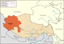 | |
|---|---|---|
| Towns and villages | ||
| Geography |
| |
| Landmarks | ||