Seni District
Seni District (Tibetan: གསེར་རྙེད་ཆུས། ; Chinese: 色尼区; pinyin: Sèní Qū) is a district within the Nagqu of the Tibet Autonomous Region, western People's Republic of China.
Seni 色尼区 • གསེར་རྙེད་ཆུས། | |
|---|---|
 | |
.png) Location of Seni (red) within Nagqu (yellow) and the Tibet Autonomous Region | |
 Seni Location of the seat in the Tibet Autonomous Region | |
| Coordinates (Nagqu government): 31°28′37″N 92°03′04″E | |
| Country | People's Republic of China |
| Region | Tibet |
| Prefecture-level city | Nagqu |
| Township-level divisions | 12 |
| County seat | Nagqu Town |
| Elevation | 4,513 m (14,806 ft) |
| Time zone | UTC+8 (China Standard) |
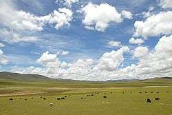
Geography and climate
Located in the northern part of the Tibet Autonomous Region, Seni ranges in latitude from 30° 31' to 31° 55' N and in longitude from 91° 12' to 93° 02' E. Bordering counties within Nagqu are Lhari to the southeast, Biru to the east, Nyainrong to the northeast, Amdo to the northwest, and Baingoin to the west, while Lhasa City, the regional capital, is to the south.
With an elevation of around 4,500 metres (14,800 ft), Nagqu has a harsh, alpine climate (Köppen EH), with long, very cold and dry winters, and short, cool summers. In winter, temperatures frequently drop below −20 °C (−4 °F) at night and in summer typically rise to 16 °C (61 °F) during the day. The monthly 24-hour average daily temperature ranges from −11.7 °C (10.9 °F) in January to 9.5 °C (49.1 °F) in July, and the annual mean is only −0.65 °C (30.8 °F). From June to September, a majority of the days receives some precipitation, and over 80% of the annual precipitation is delivered.
| Climate data for Seni District, Nagqu (1981−2010 normals) | |||||||||||||
|---|---|---|---|---|---|---|---|---|---|---|---|---|---|
| Month | Jan | Feb | Mar | Apr | May | Jun | Jul | Aug | Sep | Oct | Nov | Dec | Year |
| Average high °C (°F) | −2.5 (27.5) |
−0.8 (30.6) |
3.1 (37.6) |
7.0 (44.6) |
11.2 (52.2) |
15.1 (59.2) |
16.0 (60.8) |
15.6 (60.1) |
13.2 (55.8) |
7.9 (46.2) |
1.9 (35.4) |
−1.3 (29.7) |
7.2 (45.0) |
| Daily mean °C (°F) | −11.7 (10.9) |
−9.3 (15.3) |
−4.9 (23.2) |
−0.8 (30.6) |
3.8 (38.8) |
8.1 (46.6) |
9.5 (49.1) |
9.0 (48.2) |
6.1 (43.0) |
0.2 (32.4) |
−6.9 (19.6) |
−10.9 (12.4) |
−0.6 (30.8) |
| Average low °C (°F) | −19.9 (−3.8) |
−17.3 (0.9) |
−12.6 (9.3) |
−7.8 (18.0) |
−2.6 (27.3) |
2.2 (36.0) |
4.3 (39.7) |
3.8 (38.8) |
1.0 (33.8) |
−5.5 (22.1) |
−13.8 (7.2) |
−18.9 (−2.0) |
−7.3 (18.9) |
| Average precipitation mm (inches) | 4.1 (0.16) |
3.5 (0.14) |
4.7 (0.19) |
11.2 (0.44) |
35.5 (1.40) |
83.9 (3.30) |
104.8 (4.13) |
99.5 (3.92) |
73.8 (2.91) |
21.6 (0.85) |
4.5 (0.18) |
2.4 (0.09) |
449.5 (17.71) |
| Average precipitation days (≥ 0.1 mm) | 4.0 | 4.1 | 3.9 | 6.8 | 13.2 | 18.8 | 20.1 | 19.3 | 18.8 | 8.1 | 3.0 | 2.8 | 122.9 |
| Average relative humidity (%) | 42 | 39 | 37 | 44 | 55 | 63 | 68 | 68 | 70 | 58 | 50 | 44 | 53 |
| Source 1: China Meteorological Administration[1] | |||||||||||||
| Source 2: Weather China (precipitation days 1971–2000)[2] | |||||||||||||
Administrative divisions
The area is made up of several towns and townships:[3]
- Nagqu Town (ནག་ཆུ་, 那曲镇)
- Lhomar Town (ལྷོ་མ་, 罗玛镇)
- Golug Town (ཀོ་ལུང་, 古露镇)
- Shamong Township (ཤ་མོང་, 香茂乡)
- Yöchak Township (ཡོས་ཆགས་, 油恰乡)
- Namarche Township (ན་དམར་ཆེ་, 那么切乡)
- Kormang Township (འཁོར་མང་, 孔玛乡)
- Taksar Township (སྟག་གསར་, 达萨乡)
- Lumé Township (ལུ་སྨད་, 劳麦乡)
- Serzhong Township (གསེར་གཞོང་, 色雄乡)
- Nyima Township (尼玛乡)
- Daqên Township (སྟར་ཆེན་, 达前乡)
Transport
- China National Highway 317 runs from Chengdu in Sichuan province to Nagqu County.
- Nagqu railway station (Qinghai–Tibet Railway)
References
- 中国气象数据网 - WeatherBk Data (in Chinese). China Meteorological Administration. Retrieved 2020-04-15.
- 那曲城市介绍 (in Chinese). Weather China. Retrieved 2011-05-27.
- 那曲县历史沿革 (in Chinese). XZQH.org. Retrieved 20 February 2018.
2010年第六次人口普查,那曲县常住总人口108781人,其中,那曲镇50530人,罗玛镇6572人,古露镇3695人,香茂乡6402人,油恰乡5013人,那玛切乡7898人,孔玛乡4690人,达萨乡8098人,洛麦乡3127人,色雄乡4047人,尼玛乡4175人,达前乡4534人。
External links
| District | 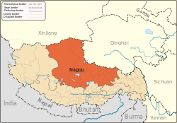 | |
|---|---|---|
| Counties | ||
| Towns and villages |
| |
| Geography |
| |