Guozha Lake
Guozha Lake (郭扎错), also Gozha Co, Gozha Tso or Guozhacuo, also known as Lake Lighten,[1] is a glacial lake in Rutog County in the Ngari Prefecture in the northwest of the Tibet Autonomous Region of China. It lies in the western Kunlun Mountains to the northwest of Bangda Lake,[2] not far from the regional border with Xinjiang.[3] Located at an altitude of 5080 metres, it covers an area of 244 square kilometres with a maximum depth of 81.9 metres and his drainage basin contains 62 glaciers.[4]
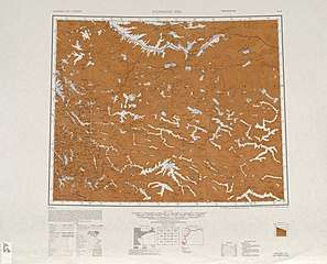
Map including Guozha Lake (labeled as LAKE LIGHTEN) and surrounding region (AMS, 1950)[lower-alpha 1]

Map including Guozha Lake (labeled as LI-T'IEN HU (LAKE LIGHTEN)) (DMA, 1973)
| Guozha Lake | |
|---|---|
 Guozha Lake viewed from space | |
| Location | Rutog County, Tibet, China |
| Coordinates | 35°1′53″N 81°5′11″E |
| Basin countries | China |
| Max. length | 30.4 km (19 mi) |
| Max. width | 11.6 km (7 mi) |
| Surface area | 252.6 km2 (100 sq mi) |
| Max. depth | 81.9 m (269 ft) |
| Shore length1 | 104 km (65 mi) |
| Surface elevation | 5,080 m (16,667 ft) |
| 1 Shore length is not a well-defined measure. | |
Notes
- From map: "THE DELINEATION OF INTERNATIONAL BOUNDARIES ON THIS MAP MUST NOT BE CONSIDERED AUTHORITATIVE."
References
- Michael Ward. “The Kun Lun Shan: Desert Peaks of Central Asia.” The Alpine Journal (1989-90), p. 90.
- Ehlers, Jürgen; Gibbard, Philip Leonard (15 July 2004). Quaternary Glaciations: South America, Asia, Africa, Australasia, Antarctica. Elsevier. p. 107. ISBN 978-0-444-51593-3. Retrieved 9 April 2012.
- Maps (Map). Google Maps.
- Glacial and lake fluctuations in the area of the west Kunlun Mountains during the last 45000 years (PDF). Annals of Glaciology, International Glacial Society. Volume 16, 1992. pp. 79–84. Retrieved 9 April 2012. Check date values in:
|date=(help)
| County-level divisions | 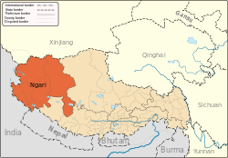 | |
|---|---|---|
| Towns and villages | ||
| Geography |
| |
| Landmarks | ||
This article is issued from Wikipedia. The text is licensed under Creative Commons - Attribution - Sharealike. Additional terms may apply for the media files.