Prince of Wales Island (Queensland)
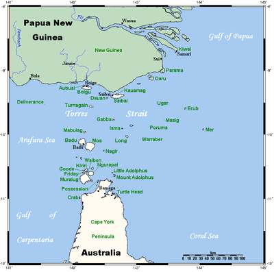
The Prince of Wales Island, or Muralag, is an island of the Torres Strait Islands archipelago at the tip of Cape York Peninsula within the Endeavour Strait of Torres Strait in Queensland, Australia.[1] The island is situated approximately 20 km (12 mi) north of Muttee Heads which is adjacent to Bamaga and south of Thursday Island. It is within the locality of Prince Of Wales within the Shire of Torres.
| Native name: Muralag | |
|---|---|
.jpg) Prince of Wales Island | |
 | |
| Geography | |
| Location | Northern Australia |
| Coordinates | 10°40′55″S 142°11′19″E |
| Archipelago | Torres Strait Islands |
| Adjacent bodies of water | Torres Strait, between Coral Sea & Arafura Sea |
| Area | 204.6 km2 (79.0 sq mi) |
| Length | 19.5 km (12.12 mi) |
| Width | 18.6 km (11.56 mi) |
| Highest elevation | 247 m (810 ft) |
| Highest point | Mount Scott |
| Administration | |
Australia | |
| State | Queensland |
| Shire | Shire of Torres |
| Island Region | Inner Islands |
| Largest settlement | Muralug (pop. 20) |
| Demographics | |
| Population | 20 (2001) |
| Pop. density | 0.1/km2 (0.3/sq mi) |
| Ethnic groups | Torres Strait Islanders |
| Additional information | |
| Largest of the Torres Strait Islands | |
Most of the land has been returned to the Kaurareg people, who are the traditional owners of the island.
Geography
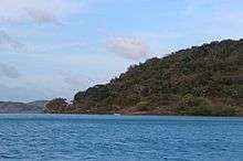
With an area of 204.6 km2 (79 sq mi), Prince of Wales Island is the largest of the Torres Strait Islands. Being inhabited only by a few Kaurareg families (population 20 in 2001), it is very sparsely populated. The town in the north of the island is called Muralug (10.6003°S 142.2036°E), after the native name of the island.[2]
The northeastern corner of the island, Kiwain Point, is only 830 m (908 yd) away from Vivien Point of Thursday Island, the main and most populous of the Torres Strait Islands, separated by Normanby Sound.
History
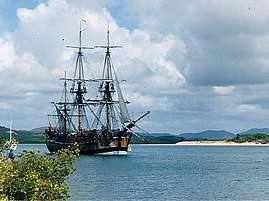
First recorded sighting by Europeans of Prince of Wales Island was by the Spanish expedition of Luís Vaez de Torres on 3 October 1606.[3]
A massacre of Kaurareg people occurred on Muralag and Wednesday Island in 1869 after it was thought that they had attacked and killed the crew of the schooner Sperwer after it was shipwrecked in 1869, and punishments continued for years, decimating the population of Kaurareg people.[4][5][6]
Language
The island's native name is Muralag. The indigenous language of the Thursday Island group is Kaiwaligau Ya, also known as Kauraraigau Ya (the name in the form of the dialect of the 1800s) [also recorded as Kaurareg and Kowrareg]. Kaiwalaig (Kauraraig) means "islander", and Kaiwaligau Ya (Kauraraigau Ya) means "islanders' language". Kaiwaligau Ya is one of the four dialects of Kala Lagaw Ya, spoken throughout Torres Strait except for the Eastern Islands, where Meriam Mìr is spoken. Most Kowrareg now use Brokan (Torres Strait Creole) for everyday communication, though the dialect still has many good mother-tongue speakers.
Education
There are no schools on the island. The nearest primary and secondary schools are on Thursday Island.[7]
References
- "Prince of Wales Island - island in the Shire of Torres (entry 27515)". Queensland Place Names. Queensland Government. Retrieved 8 April 2020.
- "Muralug - population centre in the Shire of Torres (entry 23527)". Queensland Place Names. Queensland Government. Retrieved 8 April 2020.
- Hilder, Brett The voyage of Torres, Brisbane, 1980, pp.91,95
- Sharp, Nonie (1992). Footprints Along the Cape York Sandbeaches. Aboriginal Studies Press. p. 71. ISBN 978-0-855-75230-9.
- "Hammond - Aboriginal and Torres Strait Islander peoples". Queensland Government. 26 November 2014. Archived from the original on 22 February 2020. Retrieved 22 February 2020.
- "Thursday Island (Waiben)". Queensland Government. 26 November 2014. Archived from the original on 21 January 2020. Retrieved 22 February 2020.
- "Queensland Globe". State of Queensland. Retrieved 8 April 2020.
External links
| Wikimedia Commons has media related to Prince of Wales Island, Queensland. |
List of Torres Strait topics | |||||||||||||||||||
|---|---|---|---|---|---|---|---|---|---|---|---|---|---|---|---|---|---|---|---|
| Torres Strait Islands, islets, and cays |
| ||||||||||||||||||
| People, culture, communities and languages |
| ||||||||||||||||||
| Governance and legal matters |
| ||||||||||||||||||
| Buildings and structures | |||||||||||||||||||
| Other | |||||||||||||||||||