Batemans Bay
Batemans Bay is a city in the South Coast region of the state of New South Wales, Australia. Batemans Bay is administered by the Eurobodalla Shire council. The city is situated on the shores of an estuary formed where the Clyde River meets the South Pacific Ocean.
| Batemans Bay New South Wales | |||||||||||||||
|---|---|---|---|---|---|---|---|---|---|---|---|---|---|---|---|
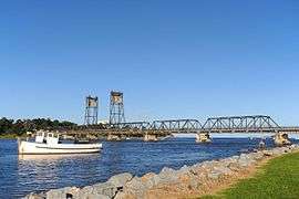 Looking towards the Batemans Bay Bridge from the banks of the Clyde River which flows into the bay. | |||||||||||||||
Batemans Bay | |||||||||||||||
| Coordinates | 35°42′29″S 150°10′28″E | ||||||||||||||
| Population |
| ||||||||||||||
| Established | 1885 [3] | ||||||||||||||
| Postcode(s) | 2536 | ||||||||||||||
| Time zone | AEST (UTC+10) | ||||||||||||||
| • Summer (DST) | AEDT (UTC+11) | ||||||||||||||
| Location | |||||||||||||||
| LGA(s) | Eurobodalla Shire | ||||||||||||||
| Region | South Coast | ||||||||||||||
| County | St Vincent | ||||||||||||||
| State electorate(s) | Bega | ||||||||||||||
| Federal Division(s) | Gilmore | ||||||||||||||
| |||||||||||||||
| |||||||||||||||
Batemans Bay is located on the Princes Highway (Highway 1) about 280 kilometres (170 mi) from Sydney and 760 km (470 mi) from Melbourne. Canberra is located about 151 km (94 mi) to the west of Batemans Bay, via the Kings Highway. At the 2016 census, Batemans Bay had a population of 11,294.[1] A larger urban area surrounding Batemans Bay also including Long Beach, Maloneys Beach and the coastal fringe extending south to Rosedale had a population of 16,485[2] at June 2018.
It is the closest seaside city to Canberra, making Batemans Bay a popular holiday destination for residents of Australia's national capital. Geologically, it is situated in the far southern reaches of the Sydney Basin.[4] Batemans Bay is also a popular retiree haven, but has begun to attract young families seeking affordable housing and a relaxed seaside lifestyle. Other local industries include oyster farming, forestry, eco-tourism and retail services.
History
Indigenous history
The traditional custodians of the land surrounding Batemans Bay are the Indigenous Australian Yuin people of the Walbunja clan. The traditional language spoken by the Walbunja people is Dhurga. A number of sites in the region are considered culturally significant to the Aboriginal peoples.[5]
European history
On 22 April 1770, European explorer Captain James Cook first sighted and named the bay.[6] Cook gave no reason for the name, which may commemorate either Nathaniel Bateman, the captain of HMS Northumberland when Cook was serving as her master from 1760–62,[7] or John Bateman, 2nd Viscount Bateman, a former Lord Commissioner of the Admiralty in the 1750s.[8]
A colonial vessel, Fly, was driven into Batemans Bay by bad weather during April 1808. Local indigenous Australians attacked her crew; resulting in three fatalities from the Fly.[9] In 1821, Lt Robert Johnston entered the bay and explored the lower reaches of the Clyde River on board the cutter Snapper.[10] Snapper Island within the bay is named after Johnston's boat. Johnston returned with Alexander Berry and Hamilton Hume and they traced the river to its source.[11] When the district was surveyed in 1828, a deserted hut and stockyards were found. Cedar getters and land clearers were in the district in the 1820s. From 1820s through to the 1840s, the area to the Moruya River was the southernmost official limit of location for the colony of New South Wales.
The Illawarra and South Coast Steam Navigation Co found the Clyde River to be navigable in 1854. Regular services by the company in the 1860s and 1870s contributed to growth of the district.[12]
The village of China Bay was surveyed in 1859. Oyster farming commenced in 1860, and by 1870, there was a fleet of 40 oyster boats. A sawmill was erected in 1870. The port and town was proclaimed in 1885.[3] A ferry service across the Clyde ran from 1891 until the bridge was opened in 1956. In 1942, during World War II, a trawler was attacked by a Japanese submarine between Batemans Bay and Moruya.[13]
In May 2016, an estimated 120,000 bats suddenly descended upon and swarmed the town, prompting the town to declare a state of emergency. Due to the fact that they were flying foxes, they had to be removed using non-lethal methods, including smoke, noise, lights and removing vegetation.[14] The town received AUS$2.5 million in order to relocate the bats.[15]
Population
The change of population of Batemans Bay since 1881.
- 1881 was 266
- 1961 was 1,183
- 1981 was 4,924
- 1996 was 9,568[16]
- 2006 was 10,845[17]
- 2011 was 11,334[18]
According to the 2016 census of Population, there were 11,294 people in the Batemans Bay urban centre.
- Aboriginal and Torres Strait Islander people made up 7.3% of the population.
- 77.1% of people were born in Australia. The next most common countries of birth were England 5.0% and New Zealand 1.5%.
- 88.1% of people only spoke English at home.
- The most common responses for religion were No Religion 26.3%, Anglican 24.8% and Catholic 23.4%.[1]
The median age in Batemans Bay is 53 years, compared with the Australian national average of 37 years. For people aged 60 years and above, Batemans Bay is well above the national average, and has twice as many people aged 70 years or over than the national average. Conversely, in all age demographic groups below 60 years, Batemans Bay is below national averages. This is most strongly presented in the categories for ages 19 years to 35 years.[19]
This skewed demographic is attributed to Batemans Bay's proximity to Canberra, from where it attracts a large number of retirees.[20] In recent years, community concern has grown as hotels and resorts in the region have been purchased and converted to aged care and retirement living, creating a perceived threat to the town's primary industry – tourism.[21] In addition, the aged demographic has been said to create a culture were the towns infrastructure is geared towards the aged, resulting in a net migration away from Batemans Bay of younger families exacerbating the imbalance.[22] In 2015, research from Nielsen revealed older people were less likely to support rates funding towards youth focussed infrastructure.[23]
Arts and culture
With its stunning natural features at the forefront, and an aged population,[24] the arts and cultural scene in Batemans Bay was seen for some time as underdeveloped for a regional hub. As the town has recently enjoyed a renaissance of its CBD,[25] so too its arts and cultural landscape, with a growing and interesting calendar of events[26] and a strong community of practicing artists.
This shift is best illustrated in the announcement of 26 million dollars toward the development of an indoor aquatic and cultural centre.[27] To be built at the Mackay Park precinct, the cultural facility will include a purpose-built exhibition and performance centre, as well as workshop and storage space that will serve the wider region's 18 art, dance and theatre groups. (While welcomed by many, the centre is not without controversy, with several community groups questioning Eurobodalla Shire Council's design and community consultation process.)[28][29][30]
A recent push by digital creatives and artists into Batemans Bay's industrial estate also signals this new chapter. Based at the South Tribe and Cultivate Space business and arts incubators, these grass roots non-government centres have spawned a thriving and growing community of artists, creatives, freelancers, entrepreneurs and digital nomads.[31]
Sculpture on Clyde - a ten-day art festival celebrating imagination in 3D, debuted in 2017 as a bold and generous new acquisitive art prize. Set along the foreshore of the pristine Clyde River, it is one of Australia's richest 3D art prizes. Presented by The Batemans Bay Tourism and Business Chamber, the festival is open to professional, emerging and novice artists worldwide with 2018 prize money to the value of $70,000. The inaugural acquisitive prize was won by Dora A. Rognvaldsdottir for Duet.[32] (As of June 15, 2018, the prize has been cancelled, due to a dispute between Batemans Bay Business and Tourism Chamber, and Eurobodalla Shire Council.)[33]
South East Arts (SEArts) is the regional development organisation for arts and culture in the Bega Valley, Eurobodalla and Snowy Monaro.
Food and produce
Batemans Bay sits as the northern gateway to the pristine Eurobodalla Shire - the entire region gaining national recognition for its terroir and as a centre for sustainable agriculture.[34] Most notably for the town itself, are the oysters from the Clyde River. One of Australia's cleanest estuaries,[35] the Clyde produces what is considered by a growing number to be Australia's best oyster. These are available widely on local menus and at farm gates.
Buildings and architecture
Batemans Bay has many historical buildings, sharing an insight into the areas colourful past. Northcourt Arcade was erected in 1935 as a hospital and operated until the 1960s. During these years the community fought for a more updated structure and all patients were moved to the new location on Pacific Street in 1970.[36]
Transport
Batemans Bay is located at the junction of the Princes Highway which runs down the south coast of New South Wales and the Kings Highway, which runs from Canberra to the coast.
Batemans Bay is the only place where coastal traffic can cross the Clyde River. From 1915 to 1954 a motorised punt allowed traffic to cross the river. The current Batemans Bay Bridge was officially opened in 1956. It is a steel vertical lift truss bridge with a maximum height of 34 metres. In 2019 work began on a replacement concrete bridge with a clearance of 12 metres.[37]
Climate
Batemans Bay experiences an oceanic climate (Köppen climate classification Cfb). The climate of Batemans Bay is moderated by the sea, with warm summers and mild sunny winters. Nights can be cold in winter. Thunderstorms mostly occur between November and March, with rainfall maximums in summer. The town gets 87.3 clear days annually.
| Climate data for Batemans Bay | |||||||||||||
|---|---|---|---|---|---|---|---|---|---|---|---|---|---|
| Month | Jan | Feb | Mar | Apr | May | Jun | Jul | Aug | Sep | Oct | Nov | Dec | Year |
| Record high °C (°F) | 45.6 (114.1) |
43.2 (109.8) |
40.8 (105.4) |
35.0 (95.0) |
27.5 (81.5) |
24.5 (76.1) |
24.1 (75.4) |
27.5 (81.5) |
36.6 (97.9) |
36.9 (98.4) |
41.0 (105.8) |
42.1 (107.8) |
45.6 (114.1) |
| Average high °C (°F) | 26.1 (79.0) |
25.6 (78.1) |
24.6 (76.3) |
22.4 (72.3) |
19.9 (67.8) |
17.4 (63.3) |
17.1 (62.8) |
18.2 (64.8) |
20.5 (68.9) |
22.1 (71.8) |
23.3 (73.9) |
24.8 (76.6) |
21.8 (71.2) |
| Average low °C (°F) | 15.8 (60.4) |
16.0 (60.8) |
14.1 (57.4) |
10.6 (51.1) |
7.1 (44.8) |
5.3 (41.5) |
3.7 (38.7) |
4.5 (40.1) |
7.1 (44.8) |
9.7 (49.5) |
12.2 (54.0) |
14.2 (57.6) |
10.0 (50.0) |
| Record low °C (°F) | 6.6 (43.9) |
7.0 (44.6) |
4.4 (39.9) |
1.1 (34.0) |
−1.0 (30.2) |
−2.0 (28.4) |
−2.9 (26.8) |
−2.3 (27.9) |
−1.8 (28.8) |
0.0 (32.0) |
1.0 (33.8) |
3.0 (37.4) |
−2.9 (26.8) |
| Average rainfall mm (inches) | 89.7 (3.53) |
103.8 (4.09) |
80.1 (3.15) |
60.3 (2.37) |
55.3 (2.18) |
81.9 (3.22) |
43.2 (1.70) |
65.8 (2.59) |
53.6 (2.11) |
85.4 (3.36) |
90.4 (3.56) |
72.3 (2.85) |
885.2 (34.85) |
| Average rainy days | 11.9 | 11.3 | 10.5 | 7.7 | 7.0 | 7.9 | 6.6 | 6.3 | 8.2 | 9.4 | 11.3 | 11.0 | 109.1 |
| Average afternoon relative humidity (%) | 63 | 66 | 63 | 62 | 61 | 61 | 57 | 56 | 57 | 58 | 61 | 62 | 61 |
| Source: [38] | |||||||||||||
Media
- Radio stations
- East Coast Radio 2EC (FM 105.9 – commercial)
- Power FM NSW South Coast (FM 104.3 – commercial) – POWER FM from Nowra can also be received in parts of Batemans Bay on FM 94.9.
- 2 EAR FM (Eurobodalla Access Radio FM 107.5 – community station)[39]
- Hot Country Radio (87.6FM – commercial – country music format)
- Sky Sports Radio (FM 96.3)[40]
- ABC South East NSW (FM 103.5) – part of the ABC Local Radio network
- Radio National (FM 105.1)
- ABC NewsRadio (FM 100.5)
- ABC Classic FM (FM 101.9) – also on 95.7 from the adjacent Illawarra region.
- Triple J (FM 98.9 – from the adjacent Illawarra region). A local service from Mount Wandera is planned, subject to the clearance of local television stations.
- Television
Batemans Bay and the Eurobodalla region receive five free-to-air television stations (television in Australia) including two government funded networks:
The ABC (ABC1), the SBS (SBS ONE) and three commercial networks:
SBS offer digital high-definition simulcasts of their main channel, SBS ONE on SBS HD.
The other networks broadcast ten additional channels: 7Two, 7mate, GO!, GEM, ABC2, ABC3, ABC News 24, SBS Two, One HD and Eleven.
- Newspapers
The local newspaper for Batemans Bay and the Eurobodalla region is The Bay Post; published by Fairfax Media.[41]
The Beagle Weekly is an independent online newspaper covering the Eurobodalla shire from South Durras to Tilba Tilba. Established in November 2016 it provides a full news service.[42]
Daily newspapers such as The Canberra Times, the Illawarra Mercury from Wollongong, the Sydney Morning Herald, the Daily Telegraph, The Australian, The Age, Herald Sun and the Australian Financial Review are available in Batemans Bay. Some local newspapers from other NSW South Coast towns such as Bega, Nowra, Ulladulla, Moruya, Merimbula and Narooma are also available.
See also
References
- Australian Bureau of Statistics (27 June 2017). "Batemans Bay (Urban Centre)". 2016 Census QuickStats. Retrieved 22 April 2019.

- "3218.0 – Regional Population Growth, Australia, 2017-18: Population Estimates by Significant Urban Area, 2008 to 2018". Australian Bureau of Statistics. Australian Bureau of Statistics. 27 March 2019. Retrieved 22 April 2019. Estimated resident population, 30 June 2018.
- "CITIES, TOWNS, AND VILLAGES". New South Wales Government Gazette (122). New South Wales, Australia. 20 March 1885. pp. 1881, 1887. Retrieved 23 April 2019 – via National Library of Australia.
- "Batemans Bay and Eurobodalla". Visit NSW. Retrieved 21 January 2013.
- "Hanging Rock Catalina", Preliminary Public Aboriginal Heritage Inventory, Eurobodalla Shire Council, April 2009
- Bladen, Frank Murcott, ed. (1893). "Historical Records of New South Wales Vol. I, Part 1 - Cook 1762-1780" (PDF). Open Library Internet Archive. C. Potter, Government Printer. pp. 145–146, 215. Retrieved 23 April 2019.
- Historical records of New South Wales, volume 1, part 1, Cook 1762–1780. Lansdown Slattery, Mona Vale. 1978. p. 160. OCLC 686639680.
- Robson, John (2009). Captain Cook's War and Peace. University of New South Wales Press. p. 107. ISBN 9781742231099.
- Mann, David Dickenson (2005) [1811]. "Chapter II: Cruelty of the Savages in Bateman's Bay". The Present Picture of New South Wales (text). London: Project Gutenberg Literary Archive Foundation. Retrieved 25 May 2013.
- Moore, Dennis (2002). "The Inlet That Eluded Bass, Batemans Bay – South Coast NSW". Morningside Internet. Archived from the original on 10 April 2013. Retrieved 25 May 2013.
- "Report from Robert Johnston to Governor Macquarie on the discovery and naming of the River Clyde". The Sydney Gazette and New South Wales Advertiser. National Library of Australia. 15 December 1821.
- Coroneos, Cosmos (2005). "Steamer Bega (1883–1908): Conservation Plan" (PDF). Parramatta, New South Wales: NSW Heritage Office: 6. Retrieved 1 February 2009. Cite journal requires
|journal=(help)CS1 maint: ref=harv (link) - Dept Environment & Heritage, NSW Government. "War casualties and the Merchant Navy". www.environment.nsw.gov.au. Retrieved 3 July 2014.
- "Australian town declares state of emergency after 100,000 bats swarm Batemans Bay". IBTimes. 25 May 2016. Retrieved 3 October 2016.
- "Batemans Bay gets $2.5 million funding to relocate bats as residents live in 'state of emergency'". ABC. 24 May 2016. Retrieved 3 October 2016.
- "Urban Centres and Localities, Ranked by Total Number of Persons: New South Wales". 1996 Census of Population and Housing. Australian Bureau of Statistics. 15 January 2008. Retrieved 25 May 2013.
- Australian Bureau of Statistics (25 October 2007). "Batemans Bay (Urban Centre and Locality)". 2006 Census QuickStats. Retrieved 25 May 2013.
- Australian Bureau of Statistics (31 October 2012). "Batemans Bay (Urban Centre and Locality)". 2011 Census QuickStats. Retrieved 25 May 2013.
- "ABS Census population data. Batemans Bay. 2016".
- "Ausstats insights. Population trends. 2014".
- "Bay Post Article. Coach House Marina resort DA for senior living".
- "NSW Govt planning report into Canberra's effect and influence on surrounding economic and housing markets".
- "2015 Niesen report into attitudes to spending and consumption by age".
- http://www.censusdata.abs.gov.au/census_services/getproduct/census/2016/quickstat/1004?opendocument
- http://www.esc.nsw.gov.au/inside-council/project-and-exhibitions/major-projects-and-works/batemans-bay-vision-and-growth-project/Batemans-Bay-Town-Centre-Vision-Workshop-Booklet.pdf
- "Archived copy". Archived from the original on 12 June 2018. Retrieved 6 June 2018.CS1 maint: archived copy as title (link)
- http://www.esc.nsw.gov.au/inside-council/project-and-exhibitions/proposals/batemans-bay-mackay-park-precinct-redevelopment-proposal
- "Pool campaign's big squeeze". Bay Post-Moruya Examiner. 20 November 2017. Retrieved 6 June 2018.
- Nguyen, Han (12 January 2018). "Locals and council bump heads over Mackay Park Batemans Bay pool". The Sydney Morning Herald. Retrieved 6 June 2018.
- Council, Eurobodalla Shire. "Statement from Mayor Liz Innes to 'Our Town, Our Say' meeting". www.esc.nsw.gov.au. Retrieved 6 June 2018.
- https://www.beagleweekly.com.au/single-post/2018/01/02/New-artists-space-Cultivate-joins-creative-push-into-BBay-industrial-estate
- http://sculptureonclyde.com.au/
- https://www.batemansbaypost.com.au/story/5471990/sculpture-on-clyde-cancelled-for-2018/?cs=233
- "Food, produce and markets". Retrieved 6 June 2018.
- "Clyde River (Bhundoo), South Coast NSW". www.southcoast.com.au. Retrieved 6 June 2018.
- Council, Eurobodalla Shire. "Batemans Bay". www.eurobodalla.com.au. Archived from the original on 20 February 2017. Retrieved 20 February 2017.
- "Batemans Bay Bridge replacement project". Retrieved 6 October 2019.
- "Batemans Bay (Catalina Country Club)". Climate statistics for Australian locations. Bureau of Meteorology. Retrieved 21 April 2019.
- "2EAR FM Home". Earfm.com. 15 October 2011. Retrieved 13 February 2012.
- "Welcome to Sky Sports Radio Australia 1017 – Your Racing & Sports Radio Station". 2ky.com.au. Archived from the original on 31 July 2012. Retrieved 13 February 2012.
- "Bay Post". Fairfax Media. Retrieved 21 January 2013.
- url=http://www.beagleweekly.com.au
Further reading
| Wikivoyage has a travel guide for Batemans Bay. |
| Wikimedia Commons has media related to Batemans Bay. |
- Mann, David Dickinson (1811). The Present Picture of New South Wales (ebook). Project Gutenberg.
- Robson, John (2005). "People associated with Cook in the Royal Navy between 1755 and 1762 (includes Nathaniel Bateman)". John Robson. Archived from the original on 12 May 2006. Retrieved 25 January 2006.
| Cities | |
|---|---|
| Townships |
|
| Local government areas | |
| National parks |
|
| Rivers and other waterbodies | |
| Towns | |
|---|---|
| Localities and rural places |
|
Main Article: Local government areas of New South Wales | |