Cay
A cay (/ˈkiː/ or /ˈkeɪ/), also spelled caye or key, is a small, low-elevation, sandy island on the surface of a coral reef. Cays occur in tropical environments throughout the Pacific, Atlantic and Indian Oceans (including in the Caribbean and on the Great Barrier Reef and Belize Barrier Reef).
Etymology
The 1492 indigenous people of the Bahamas were called "Lucayan", an Anglicization of the Spanish Lucayos, derived in turn from the Taíno Lukku-Cairi (which the people used for themselves), meaning "people of the islands". The Taíno word for "island", cairi, became cayo in Spanish and "cay" /ˈkiː/ in English (spelled "key" in American English, "caye" in Belizean English).[1]
Formation and composition

A cay forms when ocean currents transport loose sediment across the surface of a reef to a depositional node, where the current slows or converges with another current, releasing its sediment load. Gradually, layers of deposited sediment build up on the reef surface.[2][3] Such nodes occur in windward or leeward areas of reef where surfaces sometimes occur around an emergent outcrop of old reef or beach rock.
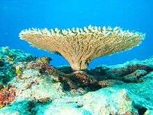
The island resulting from sediment accumulation is made up almost entirely of biogenic sediment – the skeletal remains of plants and animals – from the surrounding reef ecosystems.[4] If the accumulated sediments are predominantly sand, then the island is called a cay; if they are predominantly gravel, the island is called a motu.
Cay sediments are largely composed of calcium carbonate (CaCO3), primarily of aragonite, calcite, and high magnesium calcite. They are produced by myriad plants (e.g., coralline algae, species of the green algae Halimeda) and animals (e.g., coral, molluscs, foraminifera). Small amounts of silicate sediment are also contributed by sponges and other creatures.[5][6][7][8] Over time, soil and vegetation may develop on a cay surface, assisted by the deposition of sea bird guano.
Development and stability
A range of physical, biological and chemical influences determines the ongoing development or erosion of cay environments. These influences include: the extent of reef surface sand accumulations, changes in ocean waves, currents, tides, sea levels and weather conditions, the shape of the underlying reef, the types and abundance of carbonate producing biota and other organisms such as binders, bioeroders and bioturbators (creatures that bind, erode, and mix sediments) living in surrounding reef ecosystems.[9][10]
Significant changes in cays and their surrounding ecosystems can result from natural phenomena such as severe El Niño–Southern Oscillation (ENSO) cycles. Also, tropical cyclones can help build or destroy these islands.[11][12]
There is much debate and concern over the future stability of cays in the face of growing human populations and pressures on reef ecosystems, and predicted climate changes and sea level rise.[13][14] There is also debate around whether these islands are relict features that effectively stopped expanding two thousand years ago during the late Holocene or, as recent research suggests, they are still growing, with significant new additions of reef sediments.[15]
Understanding the potential for change in the sediment sources and supply of cay beaches with environmental change is an important key to predicting their present and future stability. Despite, or perhaps because of all the debate around the future of cays, there is consensus that these island environments are very complex and somewhat fragile.
Examples
Examples of cays include:
- The Florida Keys are composed primarily of exposed ancient coral reefs and oolite beds formed behind reefs. A few of the Florida Keys, such as Sand Key, are "cays" as defined above.
- Heron Island, Australia, a coral cay on the southern Great Barrier Reef
- Prickly Pear Cays, Anguilla
- Rama Cay, Nicaragua
- Tobacco Caye, Dangriga, Belize
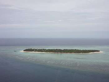
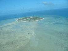
- Warraber Island in central Torres Strait (10°12′S 142°49′E), Australia, a small ‘vegetated sand cay’ according to the classification schemes of McLean and Stoddart (1978)[16] and Hopley (1982).[4] Approximately 750 m × 1,500 m (2,460 ft × 4,920 ft), this island is situated on the leeward surface of a large 11 km2 (4.2 sq mi) emergent reef platform. This cay and the surrounding reef flat are Holocene in origin, having formed over an antecedent Pleistocene platform.[17]
- Elbow Cays, Bahamas
- Great Goat Island, Jamaica
See also
References
- Albury:5, 13–14
Craton:17
Keegan:11 - Hopley, D. (1981). "Sediment movement around a coral cay, Great Barrier Reef, Australia". Pacific Geology. 15: 17–36.
- Gourlay, M.R. (1988) "Coral cays: products of wave action and geological processes in a biogenic environment" pp. 497–502. In Choat, J.H. et al. (eds.) Proceedings of the 6th International Coral Reef Symposium: Vol. 2: Contributed Papers. Townsville, Australia.
- Hopley, D. (1982) The Geomorphology of the Great Barrier Reef – Quaternary Development of Coral Reefs. Wiley-Interscience Publication, John Wiley and Sons Ltd., New York, ISBN 0471045624.
- Chave, K. (1964) "Skeletal Durability and Preservation". In: J. Imbrie and N. Newell (Eds.), Approaches to Palaeoecology. John Wiley and Sons Inc., Sydney.
- Folk, R.; Robles, P. (1964). "Carbonate sands of Isla Perez, Alacran Reef Complex, Yucatan". Journal of Geology. 72 (3): 255–292. doi:10.1086/626986. JSTOR 30075161.
- Scoffin, T.P. (1987) Introduction to Carbonate Sediments and Rocks. Blackwell, Glasgow, ISBN 0216917891.
- Yamano, H., Miyajima, T. and Koike, I. (2000). "Importance of foraminifera for the formation and maintenance of a coral sand cay: Green Island, Australia". Coral Reefs. 19: 51–58. doi:10.1007/s003380050226.CS1 maint: uses authors parameter (link)
- Harney, J.N.; Fletcher, C.H. (2003). "A budget of carbonate framework and sediment production, Kailua Bay, Oahu, Hawaii" (PDF). Journal of Sedimentary Research. 73 (6): 856–868. doi:10.1306/051503730856.
- Hart, D.E.; Kench, P.S. (2006). "Carbonate production of an emergent reef platform, Warraber Island, Torres Strait, Australia" (PDF). Coral Reefs. 26: 53–68. doi:10.1007/s00338-006-0168-8. hdl:10092/312.
- Scoffin, T.P. (1993). "The geological effects of hurricanes on coral reefs and the interpretation of storm deposits". Coral Reefs. 12 (3–4): 203–221. doi:10.1007/BF00334480.
- Woodroffe, C.D. (2003) Coasts: Form, Process and Evolution. Cambridge University Press, Cambridge, ISBN 0521011833.
- Kench, P.S.; Cowell, P. (2002). "Erosion of low-lying reef islands". Tiempo Climate Newswatch. 46: 6–12. Archived from the original on 2013-05-10.
- Hart, D.E. (2003) "The importance of Sea-Level in an Inter-Tidal Reef Platform System, Warraber Island, Torres Strait". Proceedings of the 22nd Biennial New Zealand Geographical Society Conference, Auckland, 2003. pp 77–81.
- Woodroffe, C.D., Samosorn, B., Hua, Q. and Hart, D. E. (2007). "Incremental accretion of a sandy reef island over the past 3000 years indicated by component-specific radiocarbon dating". Geophysical Research Letters. 34 (3). CiteSeerX 10.1.1.548.8845. doi:10.1029/2006GL028875.CS1 maint: uses authors parameter (link)
- McLean, R.; Stoddart, D. (1978). "Reef island sediments of the northern Great Barrier Reef". Philosophical Transactions of the Royal Society A: Mathematical, Physical and Engineering Sciences. 291 (1378): 101. doi:10.1098/rsta.1978.0093. JSTOR 75221.
- Woodroffe, C.D., Kennedy, D.M., Hopley, D., Rasmussen, C.E. and Smithers, S.G. (2000). "Holocene reef growth in Torres Strait". Marine Geology. 170 (3–4): 331–346. doi:10.1016/S0025-3227(00)00094-3.CS1 maint: uses authors parameter (link)