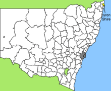
Cape Byron
Cape Byron is the easternmost point of the mainland of Australia, located in New South Wales.[1] It is about 3 km (1.9 mi) east of the town of Byron Bay, New South Wales and projects into the Pacific Ocean at 28.6335° S, 153.6383° E. A lighthouse is situated there. It is a popular area for hiking and for whale watching. Two national parks, one a conservation area and a marine park, are on the bay.
History
The cape was named by British explorer Captain James Cook, when he passed the area on 15 May 1770, to honour British explorer John Byron who circumnavigated the globe in HMS Dolphin from 1764 to 1766.[2]
The Cape is part of the Cape Byron State Conservation Area.
Cape Byron Light
Built in 1901, the Cape Byron Lighthouse is the last of the great 19th-century Victorian era lighthouses managed by the National Parks and Wildlife Service (NPWS).[3] It is constructed from concrete blocks and stands on the most easterly point of the Australian mainland.[4]
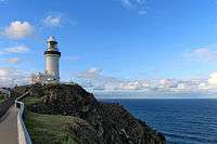 The Cape Byron Lighthouse
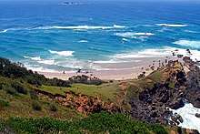
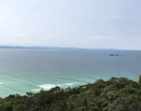 Cape Byron State Conservation Area northern coastline from the Cape Byron Lighthouse Cafe
Cape Byron walking track
The Cape Byron walking track winds through the Cape Byron State Conservation Area. The 3.7 kilometres (2.3 mi) loop walk can be started at any point with parking available at Captain Cook Lookout, Palm Valley, Wategos Beach and the Lighthouse.[5][6]
Cape Byron Marine Park
Cape Byron is part of the 22,000 hectare Cape Byron Marine Park, which was established in November 2002.[7] The area is also noted for its wildlife, with the whale watching industry a significant contributor to the local economy.[8]
Cape Byron Marine Park is a multiple-use marine park which includes protected areas where fishing and collecting are prohibited, and general-use areas which support both commercial and recreational fishing. It extends from the Brunswick River to Lennox Head, and from mean high water out to three nautical miles from the coast or islands. It includes the tidal waters of the Brunswick River, Belongil and Tallow creeks.[9] Migrating whales can typically be seen swimming past the Cape.
See also
- Cape York, the northernmost point on the Australian mainland.
- South Point, the southernmost point on the Australian mainland.
- Steep Point, the westernmost point on the Australian mainland.
- Mount Kosciusco, the uppermost point on the Australian mainland.
- Extreme points of Australia
References
- "Cape Byron Headland Reserve". Byron Bay. Retrieved 10 December 2019.
- Parkin, Ray (2003). H. M. Bark Endeavour (Second ed.). Miegunyah Press. p. 221. ISBN 0-522-85093-6.
- "Cape Byron State Conservation Area". National Parks and Wildlife Service. Retrieved 30 May 2011.
- "The Cape Byron Lighthouse". Lighthouses of New South Wales. Lighthouses of Australia Inc.
- "Cape Byron Walking Track". National Parks and Wildlife Service. Retrieved 30 May 2011.
- "Cape Byron walking track". NSW National Parks and Wildlife Service. Retrieved 7 May 2013.
- "Cape Byron Marine Park", Marine Parks Authority NSW.
- "Byron Bay Area". Visit NSW. Retrieved 19 January 2013.
- "Cape Byron Marine Park". National Parks and Wildlife Service. Archived from the original on 6 April 2011. Retrieved 30 May 2011.