Point Hicks
Point Hicks or Tolywiarar (formerly called Cape Everard), is a coastal headland in the East Gippsland region of Victoria, Australia, located within the Croajingolong National Park. The point is marked by the Point Hicks Lighthouse that faces the Tasman Sea.
| Point Hicks | |
|---|---|
| Cape Everard | |
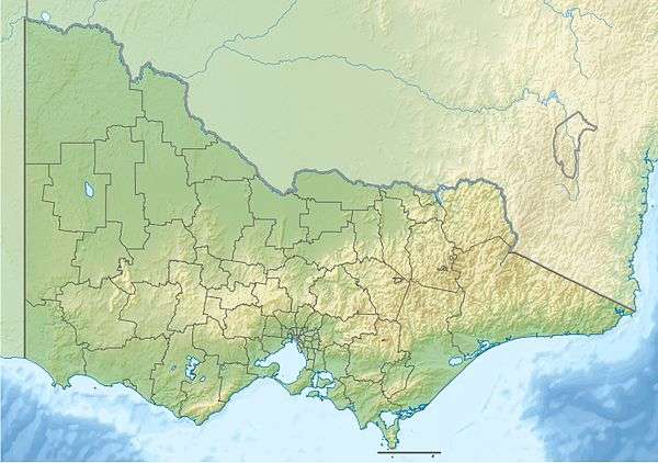 Location of Point Hicks in Victoria | |
| Location | South East Corner (IBRA), Victoria, Australia |
| Coordinates | 37°48′11″S 149°16′32″E[1][2] |
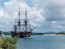
The traditional custodians of the land surrounding Point Hicks are the Australian Aboriginal Bidhawal and Gunaikurnai peoples who called the point Tolywiarar.[1][3] In April 1770 this area became the first land on the east coast of Australia to be sighted by Europeans, when HMS Endeavour reached the continent during the first voyage of James Cook to the Pacific.
Name
It was Captain Cook’s practice to reward the first person to sight land with a gallon of rum, plus the distinction of having a place named after him [4], although that place was not necessarily the feature first seen. On this occasion, the prize fell to Lieutenant Zachary Hicks who called out “Land ho” when he saw “land making high” in the hinterland of Australia’s south coast. [5]
History
When Cook came to making his chart of Australia’s east coast, he drew a point of land which he named Point Hicks and gave its coordinates as 38°0'S and 148°53'E. However, there is no land in this position. The given coordinates lies several miles off-shore, in 50 fathoms of water.
It is generally accepted that Cook’s "Point of land" was not Point Hicks [6], but the lingering question is whether his error was accidental or deliberate. Some writers believe it was accidental and that Cook was deceived by a cloudbank, or a compass error, or a faulty observation. Others now conjecture that James Cook would not make such a mistake and that his ‘error’ was deliberate, to conceal Bass Strait from Britain’s rivals, notably the French. (See also Tasmania/Insularity.)
Another book, Lying for the Admiralty: Captain Cook's Endeavour Voyage [7], which analyses the evidence contained in his chart and journal, proposed Cook concealed Bass Strait. These include Cook’s truncated map, Cook’s evasive journal entry in answer to the question of “whether they are one land or no”, Cook’s failure to verify his supposed “isthmus” when he visited Tasmania during his Third Voyage in 1777 and Cook’s previous form – he was repeating the ploy he had used a month earlier to conceal Foveaux Strait in New Zealand. These off-shore islands could be used by the enemy to mount attacks and the Admiralty did not want Cook's strategically important discoveries publicised until Britain could occupy and garrison them.
Cook's fake map worked and Tasmania's insularity was suppressed for three more decades. When news of the 1798 discovery of Bass Strait reached Europe, the French government despatched a reconnaissance expedition commanded by Nicolas Baudin. This prompted Governor King to send two vessels from Sydney to the island to establish a garrison at Hobart.[8]
In 1970 the Victorian government changed the name of the nearby coastal promontory of Cape Everard to 'Point Hicks'. It lies on dry land, about 22 nautical miles (41 km) northeast of Cook's phantom Point Hicks, where it preserves the story of Cook's first landfall in Australia.

The sighting took place at first light [9] on Thursday 20 April 1770 by Lieutenant Zachary Hicks aboard Captain James Cook's exploration vessel Endeavour. This was the first of Cook's three voyages to the Pacific, and the sighting came after 19 days' westward sailing following Endeavour leaving New Zealand on its homeward journey. Cook recorded in his ship's Journal that it was Hicks who first saw land,[10] and that later that day he (Cook) named a far-off point after Hicks: "I have named it Point Hicks, because Lieutenant Hicks was the first who discover'd this Land."[11] This was confirmed by Aaron Arrowsmith's 1798 Chart of the Pacific Ocean, clearly showing Cook's Point Hicks. Hicks did not survive the return voyage, dying soon after Endeavour left the Cape of Good Hope.
Cook estimated the coordinates of his Point Hicks (from a great distance) to be located at 38°0′S 148°53′E, a location in the sea over 60 km to the South West. Though measuring longitude in Cook's time was problematic due to the paucity of reliable marine chronometers, Cook and his astronomer's measurements of latitude were usually very accurate. Nevertheless, the latitude of 38 degrees S placed the point more than 20 km out to sea from the East-West running coastline. It is likely that the reckoning was an error, that a cloudbank was mistaken for land, and that the true location of landfall by Endeavour lies somewhat to the East of Cape Everard.[12]
George Bass sailed past the area at the end of 1797, in an open whale-boat and was unable to identify the point.[13] Although Matthew Flinders sailed past the area in 1798–99 and again in 1802–03, the coastal area near Point Hicks was always out of Flinders’ visual range. Therefore, it did not appear on any of Matthew Flinders' published charts. The name Point Hicks was still being used on maps[14] up until 1840, before being replaced and renamed Cape Everard. The first use of the new name has been attributed to hydrographer John Lort Stokes who surveyed the coast in the Beagle in 1843. It is presumed he named it after fellow naval officer James Everard Home.[2] Stokes' maps don't record the name, but many secondary sources attribute its introduction to him. The first known chart showing Cape Everard was published by surveyor George Douglas Smythe, made in 1852 and published in 1853. If he coined the name, then according to one theory he may have been referring to William Everard, commissioner of crown lands (though no record of that Everard has been found). The name Cape Everard was then adopted from 1853 up until the early 1900s, until more historical information became readily available.
Despite the adopted use of the name Point Everard to designate the promontory, Cook's original name of Point Hicks was recorded on an obelisk-shaped monument erected by the Australian Government on the site in 1924.[15] [2]:n30 The inscription on the landward side of the monument reads:[16]
"Lieutenant James Cook, R.N. Of the Endeavour, First Sighted Australia Near This Point, Which He Named Point Hicks After Lieutenant Zachary Hicks Who First Saw the Land. April 19th (Ship's Log Date). April 20th (Calendar Date). 1770." On the seaward side of the monument is a plaque listing the "Ship's Company of H.M. Bark Endeavour April 20th 1770".[2]:n30[11]
In the 1930s, the Australian business man and philanthropist Russell Grimwade commissioned stone to be quarried from Cape Everard and shipped to Great Ayton in Yorkshire. It was used to create a replica monument with an identical plaque placed at the site of the Cook family home, following Grimwade having the home dismantled and removed to Fitzroy Gardens, Melbourne in 1934.
Cook's name, Point Hicks, was officially established as the name of the cape as part of the bicentenary of Cook's 1770 voyage. Victorian Premier Henry Bolte proclaimed the new name in a ceremony at the point on 20 April 1970.
Climate
Point Hicks has a mild oceanic climate (Cfb) with pleasant summers and cool damp winters.
| Climate data for Point Hicks | |||||||||||||
|---|---|---|---|---|---|---|---|---|---|---|---|---|---|
| Month | Jan | Feb | Mar | Apr | May | Jun | Jul | Aug | Sep | Oct | Nov | Dec | Year |
| Record high °C (°F) | 42.7 (108.9) |
41.0 (105.8) |
37.8 (100.0) |
35.6 (96.1) |
27.5 (81.5) |
22.7 (72.9) |
24.0 (75.2) |
29.2 (84.6) |
31.1 (88.0) |
35.5 (95.9) |
39.0 (102.2) |
41.4 (106.5) |
42.7 (108.9) |
| Average high °C (°F) | 23.9 (75.0) |
23.8 (74.8) |
22.2 (72.0) |
19.8 (67.6) |
17.0 (62.6) |
14.8 (58.6) |
14.2 (57.6) |
15.0 (59.0) |
16.6 (61.9) |
18.7 (65.7) |
20.4 (68.7) |
22.1 (71.8) |
19.0 (66.2) |
| Average low °C (°F) | 15.8 (60.4) |
16.1 (61.0) |
15.1 (59.2) |
13.1 (55.6) |
11.1 (52.0) |
9.1 (48.4) |
8.2 (46.8) |
8.5 (47.3) |
9.6 (49.3) |
11.0 (51.8) |
12.7 (54.9) |
14.2 (57.6) |
12.0 (53.6) |
| Record low °C (°F) | 1.6 (34.9) |
6.6 (43.9) |
7.2 (45.0) |
6.0 (42.8) |
2.8 (37.0) |
2.2 (36.0) |
−2.0 (28.4) |
1.1 (34.0) |
1.8 (35.2) |
3.1 (37.6) |
4.9 (40.8) |
6.3 (43.3) |
−2.0 (28.4) |
| Average precipitation mm (inches) | 63.2 (2.49) |
57.7 (2.27) |
67.8 (2.67) |
87.9 (3.46) |
94.4 (3.72) |
113.2 (4.46) |
99.3 (3.91) |
79.7 (3.14) |
76.9 (3.03) |
76.0 (2.99) |
81.2 (3.20) |
71.5 (2.81) |
970.0 (38.19) |
| Average precipitation days | 9.6 | 8.8 | 10.4 | 12.1 | 13.5 | 14.3 | 14.1 | 14.1 | 14.1 | 13.9 | 12.5 | 10.9 | 148.3 |
| Average relative humidity (%) | 71 | 72 | 73 | 73 | 76 | 76 | 74 | 72 | 73 | 73 | 72 | 73 | 73 |
| Source: [17] (1966–) | |||||||||||||
References
- "Point Hicks: 17439". Vicnames. Government of Victoria. 2 May 1966. Archived from the original on 9 January 2014. Retrieved 9 January 2014.
- Haldane, Robert (2001). "A Beacon on the Wilderness Coast: The Story of Point Hicks (Cape Everard)". Gippsland Heritage Journal. Retrieved 27 February 2015.
- "Point Hicks Marine National Park". Parks Victoria. Government of Victoria. Retrieved 10 January 2014.
- Beaglehole, J.C. (1968). Journals vol.I. Cambridge: Hakluyt Society. p. 173. ISBN 0851157440.
- Beaglehole, J.C. (1968). Journals vol.I. Cambridge: Hakluyt Society. p. 299. ISBN 0851157440.
- Trevor Lipscombe, Cook's Point Hicks: Error that just won't go away, Captain Cook Society, http://www.captaincooksociety.com/home/detail/cook-s-point-hicks-error-that-just-won-t-go-away
- Cameron-Ash, M. (2018). Lying for the Admiralty: Captain Cook's Endeavour Voyage. Sydney: Rosenberg. pp. 148–154. ISBN 978-0-64804-396-6.
- Cameron-Ash, M. (2018). Lying for the Admiralty. Sydney: Rosenberg. pp. 155–162. ISBN 9780648043966.
- Moorehead, Alan (1968) "The Fatal Impact – An Account of the Invasion of the South Pacific 1767–1840", Penguin Books Australia Ltd., Victoria, Australia, p. 130
- "The Land of New Holland" from Parkinson's manuscript Journal dated 29/4/1770
- Cook, James (1 May 2005). Wharton, W. J. L (ed.). Captain Cook's Journal During His First Voyage Round the World Made in H. M. Bark "Endeavour", 1768–71 (e-book). Project Gutenberg.
- Trevor Lipscombe, Cook's Point Hicks: Error that just won't go away, Captain Cook Society, http://www.captaincooksociety.com/home/detail/cook-s-point-hicks-error-that-just-won-t-go-away
- Flinders, Matthew (17 July 2004). A Voyage to Terra Australis (e-book). Volume I. Project Gutenberg.
- Map by The Society for the diffusion of useful knowledge published in 1840
- Lipscombe, Trevor (August 2014). "Hydrographers v Historians — the truth about Point Hicks" (PDF). Map Matters. Australasian Hydrographic Society (24): 4–8. Retrieved 27 February 2015.
- "COOK'S VOYAGE". The Argus. Melbourne: National Library of Australia. 6 November 1924. p. 17. Retrieved 27 September 2013.
- "Climate statistics for Point Hicks". Bureau of Meteorology. Retrieved 1 February 2017.
External links
- Point Hicks lighthouse at SeaSide Lights
- Point Hicks page at Geoscience Australia